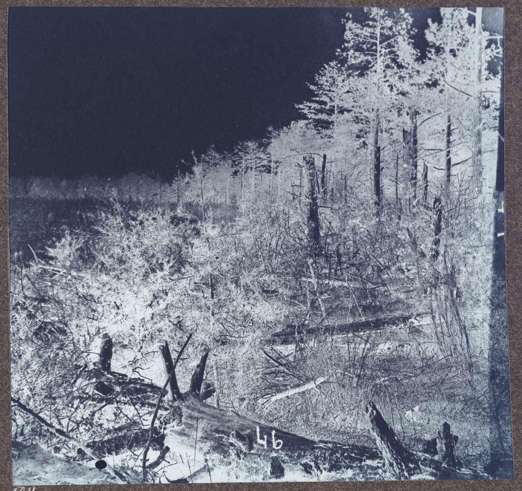

TL;DR–Mosby’s Rangers wove through the pine-strewn wreckage of abandoned 18th-century tobacco farms along Difficult Run.
A grammatical curiosity lurks in the heart of Ranger John Alexander’s wartime memoir, Mosby Men. In the chapter entitled “In Fairfax County,” Alexander describes an 1864 raid towards Little Falls that ended with Bush Underwood, William Trammell, and a handful of others ducking for cover from pursuing Federals in the forests along Difficult Run.
Determined to double back to the relative safety of Loudoun County, the band of Confederate Rangers sought out a known landmark where the possibilities for pursuit were limited and the potential for mischief was boundless. “We soon reached the shelter of the Big Pine Forest,” wrote Alexander.[i]
The capitalization was his. Big Pine Forest was a proper noun, apparently. One modified by an important article: “the.” Not just any pine forest, Alexander, Underwood, and Trammell found the Big Pine Forest. It was a known place. A landmark. An unmistakable feature.
Pines are frequent decorators in post-war accounts of John Mosby and his Rangers’ exploits in Northern Virginia. They made spaces ideal for maneuver and ambush.
Writing of Mosby’s famed Fairfax Court House raid of March 1863, Virgil Carrington Jones sets the approach of gray raiders through Federal lines near Chantilly as “en route single file through a dense growth of pine.”[ii]
Col. Mosby himself later told a story in which he compelled a civilian, Ben Hatton, to guide his men to an advantageous position behind a picket post near Frying Pan in western Fairfax County. “I gave him the choice of Castle Thunder,” wrote Mosby, “or guiding me through the pines to the rear of the picket.”[iii]
The language Mosby used to contextualize the specialized skill sets of his best scouts was couched in the language of pine trees. Writing of Bush Underwood in 1911, Mosby recalled that “Bush’s name is as inseparably linked with the pines of Fairfax as Robin Hood’s is with Sherwood Forest.”[iv]
These pines had more to offer than a channel to violence. They were also a favorite place to rest and hide.
On the evening before a June 1863 raid deep into Fairfax County, Mosby and company “passed by Frying Pan at night, and slept in a thicket of pines of the Ox Road.”[v]
Ranger John Munson recalled another Fairfax raid where Mosby sighted a Federal picket. “Colonel Mosby told us to go down and bring them (the Yankees) in while he took a little nap in the pines.”[vi]
Munson remembered at least one occasion where a mounted body of Mosby men secreted themselves in a knot of pine trees and wore them like a cloak as an unaware enemy passed by.
“On October 11, 1863,” wrote Munson, “about forty of us, under Mosby, were on a raid and scouting trip in Fairfax County, on the pike a few miles from Alexandria. We had lain hidden in the thick pines all the day before, because the Yankees were all around us, and constantly on the move along the roads.”[vii]
These pines were not a partisan thing. If Mosby famously exploited the coniferous bounty of Fairfax County, the Federals also found some benefit within jackets of scrub pine.
When Mosby men arrested a Yankee civilian, James W. Green of Vienna, on November 18, 1863, Green utilized his knowledge of the pines to manumit himself. “When we got about two miles I made my escape. I knew when the road was narrow with the second growth of pines on each side. I had made my mind that when we reached the place, I would jump from my horse and make my escape at the risk of my life,” said Green.[viii]
In December of 1864, Colonel Nelson B. Sweitzer and Captain Henry Gaylord of the 16th New York Cavalry were riding in an ambulance when Rangers ambushed them. They escaped by throwing themselves into a pine thicket.[ix]
Better still, letters from John Mosby to his wife Pauline dating to 1861 detail how a few choice ambushes laid by clever Yankees in pine stands west of Alexandria taught the future guerrilla chieftan the merits of striking out from pine thickets.
“The fight would not have been half so long,” wrote Mosby on July 24, 1861, “had it been an open-field one, but the Yankees were protected by a thick pine woods, so that it was almost impossible to get at them with the cavalry.”[x]
By 1863, student had become master and one-time ambush victim John Mosby had converted the vast pine forests of Fairfax County into favorite haunts. The appeal was obvious. Scrubby, low, and sprawling, pine forests were chaotic, disorganized spaces littered with obstacles that were prohibitive for linear columns and perfect for individual riders. A man could hide there. More importantly, a horseback rider would not be audibly discernable amidst the pines. Unlike hardwood forests with seasonal carpets of crackling leaves, pine needles soften footfalls and the whisper of wind through coniferous trees makes for a masking ambience. More vital yet, an evergreen forest provided cover twelve months out of the year. Men laying ambushes in pines could anticipate that conditions would remain more or less the same season to season.

But Where
If the famous pines of Fairfax County were so prominent in accounts of the Civil War, why were the scantly mentioned in extant documents dating to before, during, or even after the conflict?
The Difficult Run basin was rich in hardwood trees throughout much of the mid-19th century. Oak, chestnut, and hickory inspired a large scale timber exporting operation northwest of Vienna. Real estate listings gushed about old growth trees near Fox’s Mill and Frying Pan. Chancery documents and court disputes haggled over deciduous trees. Yet, none of these accounts establishing the presence of hardwood resources mention pines.[xi]
The reasoning behind this distortion in the historical record is simple. Not only were the pines worthless compared to the hardwood trees, but they were also a source of embarrassment. The presence of pines was an indictment of a century worth of failed agricultural practices.
Looking for honest assessments of local ecology in a venue as notoriously susceptible to exaggeration as real estate listings is a fool’s errand. We do better to seek out the perspective of a person with a keen eye and a certain zeal for pulling no punches.
That man was Samuel Janney, a born Virginian who delighted in excoriating his statesmen for the greed, ineptitude, and ignorance. In 1845, Janney anonymously published an agricultural jeremiad entitled “The Yankees in Fairfax County, Virginia by a Virginian.”
When he set out to grind his axe, acerbic Samuel Janney unknowingly left modern readers a key to understanding the pine forests that figured so prominently in the Mosby story.
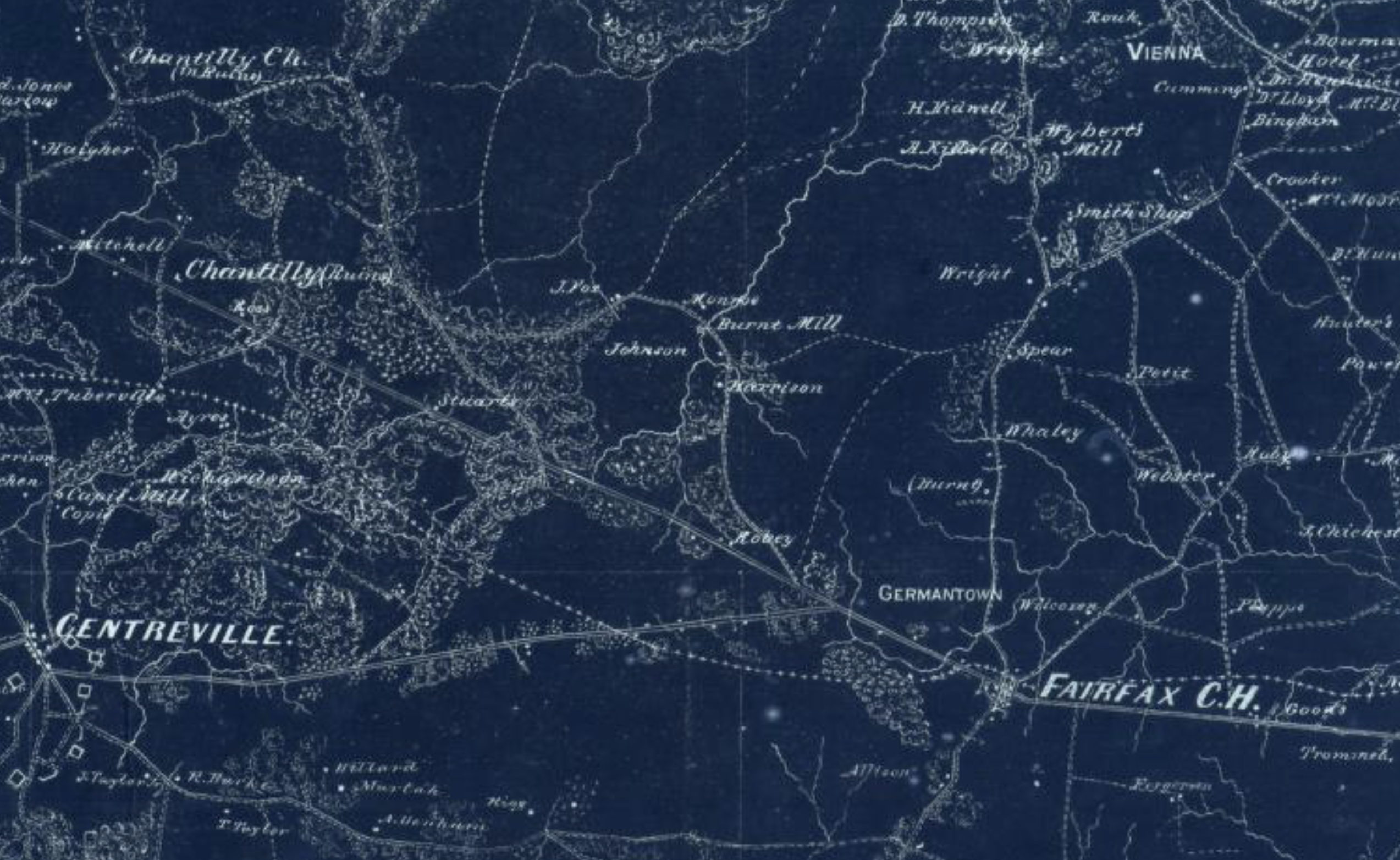
“In passing through that unfrequented part of Fairfax which lies between the Little River Road and the middle turnpike, at a distance of 15 or 20 miles from the District of Columbia, the traveler finds himself in a wilderness of pines, and journeys for miles without seeing a single habitation,” spat Janney.
The Middle Turnpike is today’s Route 7 and the “Little River Road” is Route 50, between which is the Difficult Run basin where so many Mosby men and their families lived. Measuring from the eastern side of the Arlington Memorial Bridge at the rear of the Lincoln Memorial in Washington, D.C., it is exactly fifteen miles to the intersection of Vale and Stuart Mill Roads—better known during the war as Old Bad Road and Bad Road respectively.
Was the area west of Vienna near Hunter’s and Fox’s Mills the Big Pine Forest? We will never know for sure, but it would be a strong bet.
A verifiable detail that Samuel Janney corroborated in the ensuing paragraph is that this wasteland of scrub pines was a manmade catastrophe. As Janney put it, “most of this land was formerly cultivated in corn and tobacco, and having been exhausted by the mis-directed efforts of man, is now undergoing the process which the bountiful author of nature has provided for the renovation of the soil.”[xii]
Janney’s somewhat oblique reference to “the process which the bountiful author of nature has provided for the renovation of the soil” is a long-winded way to describe what ecologists today would characterize as “succession.”
In a dynamic equilibrium, flora and fauna adjust in a push/pull that vacillates around a steady state. However, local catastrophes like a flood or a fire or soil exhaustion at the hands of overly eager tobacco planters initiate a litany of biological regimes that each create the conditions for ensuing groupings of plants and animals until stability is restored.

Taprooting plants like thistle and crab grass play important roles in “nature is healing” succession patterns. One critical way to measure the progress of natural reclamation efforts is by the height, density, and health of pine trees. Within three to eighteen years of abandonment, pine trees will establish themselves on previously exhausted soil. Within thirty years, a young pine forest will be present where once were empty fields. This pine forest will typically endure another forty years as hardwoods begin to establish themselves and assert niche dominance.[xiii]
The social and agricultural history of Fairfax County corroborates Samuel Janney’s idea that the scrub pine wasteland along Difficult Run was the result of natural succession after soil exhaustion.
Looking back from the Civil War to a time thirty to seventy years prior, conditions in Fairfax County were ripe for the abandonment of farmlands. Between 1810 and 1830, the white male population of Fairfax fell from 3269 to 2467, or nearly 25%. Historian Janice Artemel removes any ambiguity from these figures. “Migration was a major factor in the population decline,” she writes, “and underlying reason for the migration was the depletion of the soil after generations of tobacco planters had given little thought to methods of productivity.”[xiv]
Together, these many points of evidence form an important mosaic: there was not a hardwood forest along Difficult Run and a separate pine forest. Instead, there was a forest within a forest. Where ambitious early settlers carved out the best lands for tobacco cultivation, ruined the soil, and left, dense stands of pine trees sprouted between hardwood groves in the years before the Civil War.
By travelling from one overgrown former field to another, men of Mosby’s Rangers could traverse what in their mind was but one enormous pine forest.
You’ll Have to Be More Specific
As with many accounts of John Mosby and his men, specificity is not a strong suit of John Alexander’s retelling of the jaunt into the Big Pine Forest. Nevertheless, the story has enough breadcrumbs strewn about to hazard some guess work about the Ranger party’s path through the pines of Fairfax County.
In the story, Alexander, Bush Underwood, Bill Trammell and three others lace along byways until they reach a home located near Little Falls, which is near the Chain Bridge east of Langley. Finding no Federal officers to make prisoner, the group consensus was that they should “strike Loudoun forthwith.”
They “soon reached the shelter of the Big Pine Forest,” which puts that place west of McLean in the vicinity of Tyson’s Corner or Vienna. In the ensuing clause, Alexander offers an account that is nigh-on-impossible to map. Once in the pines, the squad “for hours threaded its obscure and devious bridle paths in single file, turning and twisting and doubling, it seemed to me, long after all idea of distance or direction had been lost.”
John Alexander was in good hands. Bush Underwood possessed, after all, what John Mosby described as a Robin Hood-esque association with these same woods. The winding course through the pines netted results. “About noon next day we came to a clearing,” wrote Alexander, “in which stood the humble abode of one of Bush’s friends. They were but poor folk, at best; and I doubt not that, with the precarious means of tilling their sterile soil and the frequent harassments and depredations to which they were subjected, Hard Times kept a pretty constant ‘knocking at their cottage door.’”

A son of the family stood watch while the Mosby men ate ham and eggs before striking out for the Dranesville Pike, a name sometimes given to the Middle Turnpike (Route 7).[xv]
One interesting option for the farm where friends of Bush Underwood fed the wayward band is that of John Burr. The Burr family lived just over the Loudoun County line from Herndon above Horsepen Run. Today’s toll plaza on the Dulles Tollroad is a rough approximation of the Burr farm’s location.[xvi] Of the many Mosby-friendly families west of Vienna, the Burr household stands out.
The Burr’s eldest son, Charles Nicholas or “Tobe” Burr, served in Company C of Mosby’s Rangers.[xvii] Having a son in the ranks of the 43rd Battalion Virginia Cavalry was not an unusual qualifier for that part of the world at that moment in time. What does make for an intriguing connection is the fact that Bush Underwood’s close kinsman, Samuel Underwood, married the Burr’s daughter, Georgia, in 1868.[xviii] Their firstborn child was named Thomas Singleton Underwood.
Two factors immediately disqualify the Burr household. Set on prime agricultural land amidst a Loudoun system known for its advanced attitude to soil amendments and rigorous farming science, the Burr household was unlikely to be in the same condition of squalor that John Alexander described. Additionally, John Alexander describes the friendly family as being well behind Yankee lines. The Burr household lived in that gray area between Federal pickets at Herndon and the vast sprawl of Mosby’s Confederacy to the west.
Looking farther east, a more likely farm sits at the heart of Difficult Run on Old Bad Road itself. Mahlon Trammell owned an aggressively average thirty-one acre plot of land where today’s Stuart Mill Road and Vale Road branch off from one another. Referencing the 1862 McDowell Map, Mahlon Trammell lived at the corner of Bad Road and Old Bad Road.
Trammell’s sister, Margaret, married Bush Underwood’s brother and notorious Mosby scout, John Underwood, shortly before the war.[xix] This particular brother-in-law of an Underwood would not have been on hand to welcome Bush on that summer day in 1864. Mahlon Trammell died in July of 1862. Interestingly, a post-war chancery suit between Mahlon’s administrator and other brothers indicates a fast and loose relationship with Mahlon’s land. Given the family’s concentration near Vienna and the contentious nature of their haggling over Mahlon’s property, one can’t help but wonder if the thirty-one acre plot was informally occupied during the war.
Equally enticing is a real estate listing for the land that was published in the course of the chancery suit. In an age when hyperbole ran rampant when describing property with any semblance of hardwood timber, this particular listing was notably understated. “The land is unimproved, but of good quality,” did not exactly gush inspire confidence. Instead, it sounded more like the marketing of damaged goods.[xx]
“An Up and Coming Neighborhood”
Finding the exact farm where Bush Underwood, John Alexander and company stopped over might be a fool’s errand. The descriptors are too vague and that part of Northern Virginia was too poorly documented.
There’s not going to be a battlefield marker or a plaque marking the precise boundaries of the Big Pine Forest.
By way of consolation prize, careful eyes can glean important details from similar chancery cases involving properties adjacent to or nearby that of Mahlon Trammell. With every rare tidbit of information, the area of Difficult Run near Hunter’s Mill feels more and more likely to have been set in the pine-decked wreckage of bad agricultural practices past.
Compiled under the watchful gaze of the court, material conditions are represented in an unvarnished way that bears testimony to the used-up quality of once-prized tobacco lands sitting on Difficult Run.
In the 1840s, a dispute centered around a parcel of land abutting Difficult Run just east of Hunter Mill Road. Two decades later, this same area would be the site of Mosby’s “Hidden Valley” reshoeing station. At the time of the suit, it was just another middling property that bore all the hallmarks of property that had been worked to near exhaustion.

The tract was originally held by the Gunnell family dating into the late 18th century. It passed hands to the Smiths and into the Samuel Adams family, at which time a boundary quarrel brought it to court. Asset-oriented, the chancery documents make little mention of pines. Instead, modern observers are left to read between the lines.
The white oak initially used to establish property lines on metes and bounds had been felled long before. Stumps of red oak—an inferior hardwood—had since usurped once abundant white oaks as markers. The plaintiff in the case complained about the insufficiency of wood and another assessment generously describes the situation as being in “tolerably fair timber.” Prior deeds listed Joshua C Gunnell, one of the county’s most notorious money lenders, as a co-owner.
Given the property’s proximity to both the creek and the mills nearby and the relative length of its occupation, it is safe to assume from the document that the court was assessing a plot of tobacco-ruined land. One where most high-value hardwood has been felled and brought to the sawmill and a good amount of second-rate hardwood has been similarly harvested.
It wasn’t enough. The property owners had to take on a lender as co-owner to stay afloat. When the property conveyed in 1842, this once prime creekside land carried “rights to seed wheat or rye,” both crops known to do well on nutrient-sapped soil.[xxi]
Twenty years after the fact, it would be reasonable to assume this land along Difficult Run was strapped in pine of various maturity.
One of the most telling documents from the chancery files relates to the property of John Adams. Located three quarters of a mile up Old Bad Road to the northwest of Mahlon Trammell’s property and a mile south of Hawxhurst’s Mill on Difficult Run at Lawyer’s Mill, the Adams land is the best possible example of the consequences of tobacco farming west of Fairfax.
If you view the property on either a modern or historic map, it’s easy to discern that today’s Vale Road and the Civil War’s “Old Bad Road” began its existence as a farm lane connecting John Adams’ property with Hunter Mill Road. That notoriously winding thoroughfare is an arrow-straight avenue from the main road north of Oakton (then Flint Hill) to John Adams’ one-hundred-and-forty-acre farm.
Adams was one of the first to farm this stretch of Difficult Run. His lease dates to as early as 1791, when tobacco was the prime crop and major currency of Fairfax County, Virginia.[xxii] Tobacco was so prominent that John Adams’ lease was premised not in dollars, but in an annual delivery of one thousand pounds of tobacco. When the soil gave out in the 19th century and the tobacco market collapsed, the lease was altered to thirty-six dollars per annum.[xxiii]
This same farm was the subject of an intriguing 1841 chancery case between the executors of George Thompson’s estate and John Adams. Thompson and Adams reached an agreement, by which Thompson would help Adams to bring in a crop of corn, oats and apples. Thompson held up his end of the bargain, until he died. Then Adams declined to remit Thompson’s share to his heirs.
In the course of the chancery suit, disinterested local farmers were invited to assess the harvest. John Fox put the amount of corn produced that year at somewhere between twenty-five and thirty barrels. He gauged the oat at eighty to one hundred bushels.[xxiv]
According to the Federal Reserve Bank of St. Louis, the average oat bushel production per acre for the decade between 1866 and 1876 was 24.22. Presuming similar yields, John Adams’ oat haul in 1841 would have required four acres.[xxv]
During the 19th century, nearby Loudoun and Fauquier Counties were known to be the superlative cereal-producing districts of Northern Virginia. Standard yield there at that time was thirty to forty bushels of corn an acre.[xxvi] Assuming that John Adams’ hilly Fairfax land was not as productive, we can still guess that his corn harvest from 1841 came from somewhere in the neighborhood of three acres.
In her history of Oakton, Virginia, D’Anne Evans highlights lease terms from the late 18th century, in which owners stipulated the cultivation of at least one hundred apple trees.[xxvii] According to the National Park Service, American farms of John Adams’ vintage could have as many as fifty apple trees per acre.[xxviii] If we again bake overages into this figure, it’s reasonable to assume that as many as four acres could have been devoted to fruit production in 1841.
Even with generous calculations, the amount of harvest John Adams reaped in 1841 couldn’t have consumed more than fifteen acres of his one-hundred-and-forty-acre farm. It is unlikely that a man who had to hire out labor just to get a crop in would be routinely clearing new land and rotating crops. What then of his remaining one-hundred-and-twenty-five acres?
The history of intense tobacco cultivation and the limited nature of agriculture on this farm along Difficult Run in the decades before the Civil War suggests one thing: pine trees.
Bridle Paths
Modest tenant farming along Difficult Run meets all of the essential ecological preconditions for a Civil War-era pine forest. Early and aggressive tobacco farming, hardwood deforestation, and later shifts to subsistence agriculture on limited parcels are all factors that would lend themselves to coniferous succession peaking around the 1860s.
Interwoven with these material details are hints at social geographies that match John Alexander’s description of advantageous bridle paths winding through pines between points of local interest.
It is significant that John Fox travelled to John Adams’ farm in 1841 to judge his agricultural output. Fox was a good choice. He owned a vast 541-acre spread a mile south on Difficult Run. One of the first in the area to successfully experiment with sheep in the burgeoning merino wool market, John Fox also grew large quantities of wheat, oats and corn before, during, and after the Civil War.[xxix]
A jaunt between the former Adams farm and John Fox’s spread is hardly a passing concern today. Vale Road connects the two properties. In 1864, “Old Bad Road,” which ran a slightly different and more direct course than today’s Vale Road, would have bridged the two farms easily. In 1841, however, the roadway connecting John Adams to John Fox was not yet in service.
Four years after John Fox assessed John Adams’ harvest, Mr. Fox went to the state and begged support for “a road from Hunter’s Mill Road…through the land of George W Hunter where Vincent Thompson now lives…between Fox and William Gunnell and Gabriel Fox’s land…on to the Little River Turnpike Road at some point between Ayre’s and Charles Stewart.”[xxx]
The result—modern Vale Road—was cobbled together from farm lanes, informal paths, and new cut traces. Was enough of the road present in 1841 so that John Fox could leisurely stroll from his home to John Adams? Maybe. Would he? Potentially not.
John Fox obviously enjoyed relationships with farmers closer to the Hunter Mill corridor, but the primary axes of his life—his social, business, and kinship relationships—skewed south towards the mill complex that bore his family’s name. Immediately abutting the southern end of his property was Fox’s Lower Mill, which was a woolen mill. Not coincidentally, John Fox himself was the largest wool producer in the area. Little is known about the lower mill, but records hint that the construction of that facility may have been an “all in the family” affair.[xxxi]
Just below the dam at the Lower Mill, a road trace (modern Fox Mill Road) crossed Difficult Run at the corner of John Fox’s property before lacing up to Jermantown. This would have provided John Fox valuable access to the Court House and its markets, as well as the turnpikes that funneled agricultural products towards Alexandria.[xxxii]
More telling still, are the terms of John Fox’s burial in 1877. He was interred in a family plot near modern-day Full Cry Court in Oakton. This important family focal point was almost as far as possible from John Adams’ farm.[xxxiii] From this place, there was absolutely no spatial advantage had John Fox wound his way down a yet-to-be-completed assortment of farm lanes on the future path of Old Bad Road rather than simply walking down to his creekside pastureland and wandering along Difficult Run to John Adams’ farm.
This salient point—convenience—cannot be understated. In this section of Difficult Run, four mills sat within five miles of one another. For farmers like John Adams and John Fox, it would have been far easier to take raw materials, especially timber, on informal paths following the course of the creek to the mills rather than trek uphill to a shoddy road and wind over hill and dale.
Further developments to the John Adams farm underscore the role potential prewar relationships and routes of convenience had in seeding Mosby’s guerrilla campaign.
John Adams died in the 1850s. The Hawxhurst Brothers—prominent Yankee interlopers—entered the neighborhood shortly thereafter and purchased Colonel Broadwater’s old mill on Difficult Run at Lawyers Road. A man named Isaac Leeds, the Hawxhurst’s brother-in-law, came to own John Adams’ farm before the Civil War.[xxxiv]
How did this Yankee family visit with one another? What paths did they take? These are different versions of similarly pressing questions from earlier in the property’s history. When John Adams needed his oat and corn gristed or his apples distilled, how did he get to the mill?
From the heart of the property, one could travel creekside and reach the mill on Lawyers Road within one mile. If they took roads, the same destination was over two miles distant. Are we meant to believe that there wasn’t a path of convenience darting through the spare acreage near Difficult Run? Are we supposed to believe that early residents of Difficult Run delighted in taking the long route? Should we deny practical geography?
Paths of War
Civil War history contradicts any idea that local forces stuck to the main roads. The Hawxhursts and their brother-in-law were not at home in the Big Pine Forest during the conflict. Instead, Confederate guerrillas roamed these woods.
It’s interesting that an area in limited cultivation decades before the war with a patterned history of soil exhaustion due to tobacco cultivation would play host to specific ambushes executed by men with kinship relationships to people who lived just over a mile upstream.
On April 19, 1863, John Underwood and a handful of other Rangers snatched Yankee Lt. Robert Wallace and a private in the area around Hawxhurst’s Mill.[xxxv] When tasked with initiating a designed ambush of a Federal company not long thereafter, John Underwood selected these same thickets along Lawyers Road as his blind.[xxxvi]
There never was nor never will be a map of the Big Pine Forest of Fairfax County, Virginia, nor the bridle paths that snaked through it. Instead, we’re left to make inferences about the land, its people, and the practices that connected the two.
Even vague framework has its own crystal clarity. In the late 18th century, sandy, loose, well-watered soil along Difficult Run made for the most profitable bottomland cultivation of tobacco. Creekside tracts were most apt to be exploited early and often. These plots were also the most likely to be abandoned or partially fallowed by 1800. They were thus most likely to return to forest as pine and most likely to be purchased on the cheap by Yankees in the 1840s and 1850s. When the war came, these lands were most likely to shelter guerrillas and scouts.
It’s intriguing to imagine Mosby men darting through stands of pines. It’s essential to understand that a core facet of John Mosby’s fighting doctrine in Fairfax County involved harnessing waste. These farms with their scrubby pines were the waste product of bad farming. The people who lived there were floating on a skim of marginalization just above poverty. Both the people and their places were primed to host and facilitate a guerrilla conflict.
When John Mosby found and recruited these assets to his cause, he harnessed potent forces that ensured his uncontested ownership of the unmapped Big Pine Forest until war’s end.
[i] Alexander, John H. Mosby’s Men. Washington: Neale Publishing Company, 1907. https://babel.hathitrust.org/cgi/pt?id=mdp.39015013708683&seq=11
[ii] Jones, Virgil Carrington. Ranger Mosby. Chapel Hill, University of North Carolina Press, 1944. P. 91.
[iii] Mosby, John S. War Reminiscences. New York: Dodd, Mead & Company, 1887. P. 32.
[iv] Mosby, John S. “Col. Mosby Tells How He Once Spoiled the Yankees’ Thanksgiving Feast.” The Washington Times. November 30, 1911. P. 6, Col. 3. https://tile.loc.gov/storage-services/service/ndnp/dlc/batch_dlc_american_ver01/data/sn84026749/00294557660/1911113001/0908.pdf
[v] Mosby, John S. War Reminiscences. New York: Dodd, Mead & Company, 1887. P. 154.
[vi] Munson, John W. Reminiscences of a Mosby Guerrilla. New York: Moffat, Yard and Company, 1906. P. 159.
[vii] Ibid 216.
[viii] Mauro, Charles V. The Civil War in Fairfax County. Charleston: The History Press, 2006. P. 116.
[ix] Keen, Hugh C. And Horace Mewborn. 43rd Battalion Virginia Cavalry Mosby’s Command. Lynchburg: H.E. Howard, Inc, 1993. P. 234.
[x] Russell, Charles Wells, ed. The Memoirs of Colonel John S. Mosby. Boston: Little, Brown, and Company, 1917. https://docsouth.unc.edu/fpn/mosby/mosby.html p. 52.
[xi] Johnson, Dan. “Into the Trees.” Old Bad Road. November 22, 2024.
[xii] Janney, Samuel. “The Yankee in Fairfax County, Virginia by a Virginian.” Baltimore: Snodgrass & Wehrly, 1845. No. 4, pg. 11. https://reader.library.cornell.edu/docviewer/digital?id=may864316#mode/1up
[xiii] “Forest Succession.” Office of Duke Forest. Accessed 5/15/25. https://dukeforest.duke.edu/forest-environment/forest-succession/
[xiv] Netherton, Nan, Donald Sweig, Janice Artemel, Patricia Hickin, and Patrick Reed. Fairfax County, Virginia: A History. Fairfax: Fairfax County Board of Supervisors, 1978. P. 152-156.
[xv] Alexander, John H. Mosby’s Men. Washington: Neale Publishing Company, 1907. P. 67-71. https://babel.hathitrust.org/cgi/pt?id=mdp.39015013708683&seq=11
[xvi] Parvez, Gibran. “Heritage Dulles.” Accessed 5/25/25. https://heritagedulles.com
[xvii] Keen, Hugh C. And Horace Mewborn. 43rd Battalion Virginia Cavalry Mosby’s Command. Lynchburg: H.E. Howard, Inc, 1993. P. 302.
[xviii] Virginia Marriages, 1785-1950. Family Search. Accessed 5/25/25. https://www.familysearch.org/ark:/61903/1:1:XR6B-VXD?lang=en
[xix] Keen, Hugh C. And Horace Mewborn. 43rd Battalion Virginia Cavalry Mosby’s Command. Lynchburg: H.E. Howard, Inc, 1993. P. 377.
[xx] “ADMRS of Mahlon Trammell vs David Trammell, ETC.” Virginia Chancery Archives. 1878-014. Case #: CFF94 M. https://www.lva.virginia.gov/chancery/full_case_detail.asp?CFN=059-1878-014#img
[xxi] “Temple Smith vs Samuel Adams ETC.” Virginia Chancery Archives. 1861-001. Case #: CFF83H. https://www.lva.virginia.gov/chancery/full_case_detail.asp?CFN=059-1861-001#img
[xxii] Evans, D’anne A. The Story of Oakton, Virginia: 1758-1990. Oakton: The Optimist Club of Oakton, 1991. P. 10.
[xxiii] Ibid 26-27.
[xxiv] “ADMR of George Thompson vs John Adams.” Virginia Chancery Archives. 1841-028. Case #: CFF93 S.
[xxv] “Oat Crop, Yield Per Acre for United States.” Federal Reserve Bank of St. Louis. Accessed 5/20/25. https://fred.stlouisfed.org/series/A0137IUSA254NNBR
[xxvi] Scheel, Eugene. “Cornstalks Rooted in Area’s Agricultural History.” The History of Loudoun County, Virginia. Accessed 5/19/25. https://www.loudounhistory.org/history/agriculture-corn/
[xxvii] Evans, D’anne A. The Story of Oakton, Virginia: 1758-1990. Oakton: The Optimist Club of Oakton, 1991. P. 14.
[xxviii] “Orchard History: Fruit Introduction and Cultivation, 1600-1800.” National Park Service. Accessed 5/21/25. https://www.nps.gov/articles/000/historic-context-orchards-1600-to-1800.htm#:~:text=Fruit%20introductions%20were%20primarily%20from,approximately%2050%20trees%20per%20acre.
[xxix] If you understand John Fox, you understand the Old Bad Road/Difficult Run/John Mosby paradigm. We have really clear numbers from the 1870 ag schedule to the US Census (United States Agricultural Census 1870. ancestry.com. <https://ancestry.com/search/collections/catalog/>). Additionally, we know from the 1850s tax rolls that John Fox had assembled a strong holding of both dairy cows and sheep (Tax Records, 1817-1942. Historic Records Center. Fairfax County Courthouse). In an era of profound devastation, John Fox managed to hold on to a bulk of his livestock. This suggests some degree of protection from the depredations of passing soldiers from both armies.
[xxx] Fairfax County Road Petitions. Box 1: 1844-1908. Historic Records Center. Fairfax County Courthouse. Griffin, John and Fox, John RP-007 July 1845.
[xxxi] Milliken, Ralph LeRoy. Then We Came to California: A Biography of Sarah Summers Clarke. Merced: Merced Express, 1938. Https://hdl.handle.net/2027/mdp.39015041065445. P. 12.
[xxxii] Fairfax County Road Petitions. Box 1: 1844-1908. Historic Records Center. Fairfax County Courthouse. John Fox, RP-051 April 1867.
[xxxiii] Conley, Brian A. “Fairfax Courty Cemetery Survey.” Accessed 5/31/25. https://research.fairfaxcounty.gov/c.php?g=1316298&p=10353055
[xxxiv] Evans, D’anne A. The Story of Oakton, Virginia: 1758-1990. Oakton: The Optimist Club of Oakton, 1991. P. 26.
[xxxv] O’Neill, Robert F. Chasing Jeb Stuart and John Mosby. Jefferson: McFarland & Company Inc, 2012. P. 152.
[xxxvi] Ibid 207.


