Author: Dan Johnson

  • The Critical Interval

    The Critical Interval

    tl;dr–Mosby’s activities along Difficult Run were at their most intense between February and October of 1863 on a 4.4 mile-long line connecting Fox’s Lower Mill with Hunter’s Mill

    (An image of Mosby’s guerrillas ransacking a group of Federal sutlers. Published in September 1863 on the cover of Harper’s Weekly. Courtesy LoC.)
    “MOSBY” vs. Mosby

    The legend of John Mosby—the Gray Ghost—sometimes has the feel of a shell of fabrications shellacked around a robust kernel of truth. 

    Lieutenant Colonel John Singleton Mosby was undoubtedly a brave, capable, and accomplished soldier. His actual exploits in the saddle are well-documented. For over two years, he and his band of irregular cavalry engineered a complex cat-and-mouse game designed to fix 50,000 federal troops in almost four hundred square miles of Northern Virginia where they could not contribute to the Army of the Potomac’s attempts to destroy Robert E. Lee’s Army of Northern Virginia. 

    The game for Mosby scholars is to parse out what Mosby actually did from what he has been credited with doing.

    It’s a phenomenon not unlike the case of the Vietcong a century later. “Charlie” became a catch-all nom-de-guerre for the efforts of a wide-ranging group of allied soldiers whose collective success lent itself to the imagination of an omnipresent enemy.

    Beginning in January of 1863, the name “Mosby” functioned in much the same way for citizens and soldiers stationed in Northern Virginia. It referred less to a single man than to a wide category of hit-and-run attacks.

    This broad fabric of violence often included simultaneous attacks staged dozens of miles apart. Unless John Singleton Mosby was blessed with Santa Claus-esque omnipresence, his participation in everything for which he is credited is unlikely. 

    It’s worth noting that the most-recent roster for the Mosby Rangers (alias: 43rd Battalion Virginia Cavalry) features no less than 1,881 names.1 This figure represents more men than someone in Mosby’s position could ever direct in a single battle. Especially in an asymmetrical combat environment where small groups of men gathered to initiate brief raids. 

    Simply put, John Mosby wasn’t present every time his men fought. 

    That obvious fact doesn’t even begin to account for the actions of other Confederate guerrilla units who operated in Mosby’s area and were mistaken for his men. Elijah White’s 35th Battalion Virginia Cavalry, the Iron Scouts of the 2nd South Carolina, and the Black Horse Cavalry of the 4th Virginia were all active in the vicinity.2 Other units like the Prince William or Chinquapin Rangers acted independently for long stretches of time before eventually folding in to Mosby’s Rangers. 

    In official records and the mind’s eye of the federal soldiers that these units terrorized, the unknown assailants were none other than Mosby himself. 

    The distortion continued well into the post-war period. By the end of hostilities, “Mosby” was a well-known brand and having fought him was a badge of honor that carried immediate name recognition.

    It’s a safe bet that many of those who trafficked in “Mosby” stories after the war had never met the man himself. In one instance, the memoirs of former Fairfax County sheriff and devoted Yankee scout Jonathan Roberts touted the unlikely distinction of having fought “Mosby’s guerrillas” ten months before Mosby’s guerrillas ever existed.3

    Though premised on a wealth of untruths, the Mosby legend is an important part of historiography. The tall tales that surround John Singleton Mosby are both a testament to the efficacy with which he marauded the American consciousness and also one last cloak of secrecy veiling his true deeds. 

    (The 1912 Fairfax County Topographic Map serves as base layer, with the off-lavender shape marking the rough outline of the UPPER Difficult Run Basin [from near headwaters around the Fairfax County Government Center to Hunter’s Mill and the modern W&OD Trail] while the gray line denotes the critical interval of Mosby activities along Difficult Run in 1863)
    The Critical Interval

    Piercing this mythic veil is essential. 

    The real challenge—one that 50,000 Federal troops were not capable of achieving—is to pin John Singleton Mosby at a single point in time and space. 

    I’m looking to winnow down a massive body of geographic and temporal Mosby lore into a tighter envelope. Even in the context of this project, which deals chiefly in the time span between January of 1863 (when Mosby’s command was chartered) and April of 1865 (when Mosby capitulated) and the nearly fourteen square miles of space forming the Upper Difficult Run Basin, the coordinates are almost too broad for meaningful analysis.

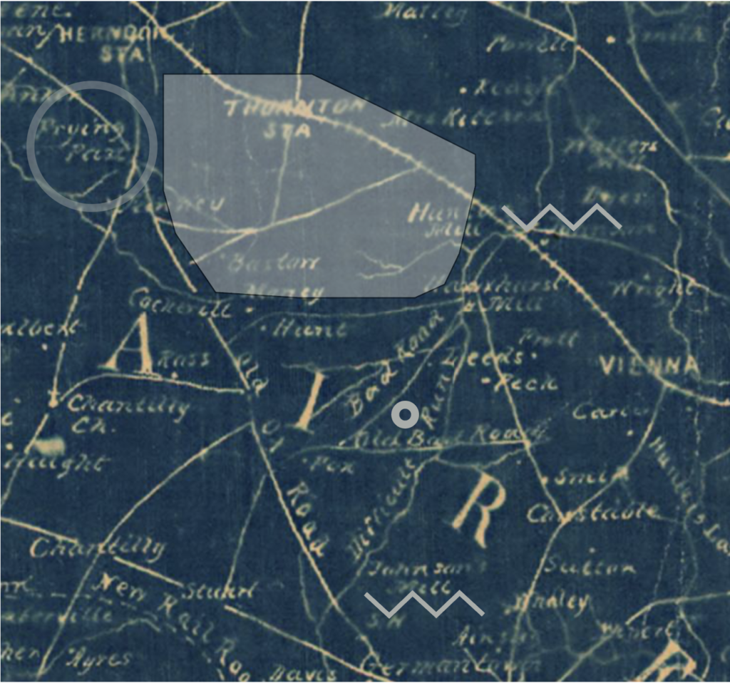
    A critical interval is necessarily specific: between February 22 and October 22, 1863, John Mosby and the earliest iterations of his Rangers utilized a corridor of friendly farms hidden behind hills and thicket in a 4.4 mile span of Difficult Run jacketed by Fox’s Lower Mill to the south and Hunter’s Mill to the north. 

    The cult of Mosby is steeped in broad stroked assurances that can feel short on specifics at times. It’s important to rigorously defend the dimensions of the critical interval. In this case, a short and poetic passage about shadowy horsemen darting forth from unknown forests in the dead of night will not suffice.

    Out of the Fire and Into the Frying Pan
    (Frying Pan Meeting House as it appears from VA Route 657 on Google Maps, looking not dissimilar from the way it did when I attended “pioneer camp” there in the summers during the mid-90s.)

    January 5, 1863 is a perfect moment to begin shelling the core of John Mosby’s wartime efforts in Fairfax County from the lore of “Mosby.” On this day, Mosby’s command—sanctioned and ordered by JEB Stuart—made its first foray into Fairfax County. 

    Reverend Louis Boudrye, historian of the 5th New York Cavalry regiment which was then picketing the Federal outpost line between Herndon and Centreville, recorded the loss of thirteen men captured near Frying Pan and Cub Run.4

    Soon thereafter, Mosby recrossed the Rappahannock and reported to Stuart. With fifteen picked men, Mosby darted northwards again on January 18 (erroneously recorded in his own memoirs as January 24). 

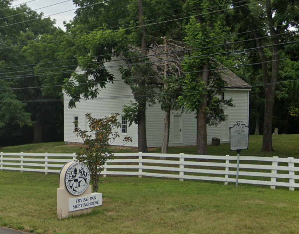
    For the next month, Mosby made forays to the vicinity of Frying Pan Church and Chantilly. This is the first chapter in the story of his independent command and an important preface to the story of John Mosby in and around Difficult Run. 

    With successive attacks on January 26 at Chantilly and January 31/February 1 and again on February 7 at Frying Pan, Mosby began to formulate a doctrinal pattern. His obsession with Frying Pan as a first point of assault is telling. 

    At Frying Pan, the axis of Federal cavalry patrols (then slicing north/south along the Centreville Road between Herndon and its titular terminus) was intersected by bramble thickets and timber that hid the irregular course of Horsepen Run. 

    The stream was a point of integration where the broad, flat Culpeper Basin scrunched up against the crystalline ridges that divide the sprawling plains from the sunken Difficult Run basin just to the east. Here sixteen men unbeholden to roads could follow the hidden course of the creek on a direct path past and through Federal lines. 

    At the earliest moment of his command, John Mosby discovered great success at a point where advantageous and unpicketed water courses could be used as unorthodox roads. 

    So too, Mosby gravitated to the vicinity of Frying Pan on Horsepen Run because of a prior association with friendly locals. To wit: Laura Ratcliffe. A dyed-in-the-wool Southern sympathizer and a principal figure in one of the lovey-dovey, extra-marital friendships that dotted JEB Stuart’s life, Ratcliffe was a reliable source of timely intelligence for Mosby throughout his guerrilla career. 

    By January 1863, Mosby has a pre-existing relationship with Ratcliffe. In fact, she and her first cousin Antonia Ford (later arrested under suspicion of providing Mosby with intelligence herself) were possibly the impetus for Mosby’s first jaunt through Difficult Run when in the winter of 1861-62 Stuart tasked then Private Mosby with accompanying two women on a snowy journey from Fairfax Court House to a house “near Frying Pan.”56 

    As maps of the era reflect, the path between Frying Pan and Fairfax was best served by a conglomeration of roads following the path of today’s Waples Mill Road to West Ox Road. Mosby could have taken the cousins on the longer route, but by 1862, a pocket of infrastructurally devoted Baptists living on Difficult Run at Fox’s Mill had ensured a reliable route from Jermantown directly to the Baptist Meeting House at Frying Pan.7 So prominent was the road that Federal maps mistook it for the “Old Ox Road.”8 

    When Mosby gravitated towards Ratcliffe in January of 1863, he invoked a prior relationship and a potential source of intelligence. Seen in another way, he was building a valuable doctrinal cornerstone by absorbing someone’s specific place knowledge into the operational capability of his command. 

    This pattern repeats itself frequently in the Mosby story. Rangers were recruited not just for their handiness with horse and pistol, but for their ability to provide privileged place knowledge. 

    Underwood, Literally

    Nowhere is this more apparent than the discovery and enlistment of John Underwood in early January of 1863. Described as “a resident of Frying Pan,” Underwood was—true to his name—a woodsman engaged in the timber industry.9 Virgil Carrington Jones said of Underwood that he “knew paths not even rabbits had found.”10

    Mosby is said to have literally happened on Underwood in a thicket one day. A keen and immediate contributor to Mosby’s agenda, Underwood led Mosby into his very first engagements along Horsepen Run at Frying Pan.11

    John Underwood was no one trick pony. The place knowledge he brought and integrated into the Mosby command was sprawling and priceless. As fellow Ranger John Munson would say of the company’s first and most prominent scout and his brother, Bushrod, “These Underwoods knew that country better than the wild animals that roamed over it by night or by day, and they were Mosby’s guides on many of his scouts and raids and never led him astray. By night or by day any of these boys could thread his way through any swamp or tangled forest in Fairfax County, and personal fear was a thing unknown to them.”12

    Though a resident of Frying Pan, Underwood’s profession made him intimately acquainted with the belt of heavy timber that stretched along the Alexandria, Loudoun, and Hampshire Railroad on a line eastwards through Hunter’s Mill and Vienna—prime locations along Difficult Run where Mosby and his men would eventually lurk.13

    (John Underwood’s World as it appeared on the 1862 Federal McDowell Map. Frying Pan, near which Underwood lived, is circled at top left on the Ox Road. The shaded area just to the east is the belt of heavy timbered which was heavily extracted by the Thornton Brothers in the late 1850s, especially via the AL&H Railroad line at Thornton’s Station. The smaller circle at center on Old Bad Road itself is the home of Underwood’s brothers-in-law, the Trammells. Zig Zags to the south and north mark the respective ends of the critical interval at Fox’s Lower Mill–known sometimes as Johnson’s Mill–and Hunter’s Mill.)

    Underwood’s local knowledge extended beyond the professional into the personal. Shortly before the war, John Underwood married Margaret Trammell.14 His second wife, Margaret was part of a broad kinship network that once handled much of the milling along Difficult Run.15 Sons of the Trammell family and interwoven Gunnell families would eventually form important aspects of Mosby’s command. It’s worth noting that in 1860, much of the land still owned by the Trammells sat along Hunter Mill Road. Some of these parcels were located just above Difficult Run along Old Bad Road.16 

    In a very real sense, Mosby was able to gain a foothold at Frying Pan and begin projecting into Difficult Run because of the illuminating influence of John Underwood’s unique spatial history. On April 19, 1863,  Underwood and fellow ranger Walter Franklin captured Lieutenant Robert Wallace of the 5th Michigan Cavalry while scouting the woods near Hawxhurst’s Mill (just west of Hunter’s Mill Road on Lawyers).17 In June, Mosby tasked Underwood with initiating an ambush intended to draw federal forces into a larger bushwhack somewhere north of Fox’s Mill. Underwood chose a position along Lawyer’s Road where he could slip away in familiar thickets that were prohibitively dense and unnavigable to his pursuers.18

    Both of these vignettes occur in the critical interval, but say more about Underwood than Mosby. Each is a superlative individual effort play executed by a skilled and brave woodsman who returned to his old professional stomping grounds and the haunts of his in-laws to do his dirt. 

    More telling than John Underwood’s ability to scout and snipe alone in Difficult Run is the centripetal influence he exerted on Mosby’s command at large. The area access and path knowledge he brought to the table enabled Mosby to traverse the upper reaches of Horsepen Run. Here, Federal cavalrymen were strung out in a loose array of pickets and patrols on prominent North/South ridge roads perched above the timber tracts in Upper Difficult Run.

    With clear access and superior bridle-path intelligence, Mosby and his men began to undermine the Yankee position guarding Difficult Run. On February 1, the Gray Ghost and his men compelled the assistance of a neutral local, Ben Hatton, to thread through a Union ambush and stab at a picket post near the Tyler Davis house in the vicinity of today’s Fox Mill Shopping Center on Reston Parkway.19

    (Piggy-backing off the post-war 1879 Hopkins Map depicting the Dranesville District of western Fairfax County is useful. Note Horse Pen run lacing through Frying Pan towards the Tyler Davis and Thompson properties. Marked below in orange is the road known during the war as “Old Bad Road.” Underlined thereabouts is the property owned by John Underwood’s in-laws. At top, notice the milling facilities for the old Thornton timber operation. More importantly, observe the largely unpopulated gap between Frying Pan and Hunter’s Mill above Lawyers Road. This section of Upper Difficult Run was partially sold off in the 1850s, but remained sparsely populated thanks to a timber industry [with a geography that Underwood would have known well] and a post-war dairy boom.)

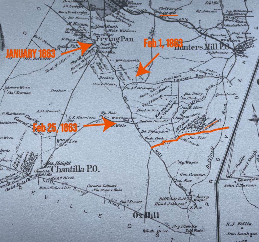
    On February 25, 1863, the command dominated a 50-man Federal picket relief post at the Thompson Farm. Located just under a mile north of Ox Junction where the road to Fox’s Mill, Old Bad Road, and the Ox Road intersected on the heights above Difficult Run, the Thompson’s Corner raid was a dominant victory for Mosby and an important milestone for his command.20 

    February 25 marked the opening of the critical interval. Bruised by two months of blind dust-ups against a determined and apparently informed rebel force, Federal cavalry commanders were beginning to waver in their defense of the phase line just to the west of Difficult Run. By early March, the Federal line protecting Frying Pan on the Herndon/Centreville road was found to be porous and poorly maintained.21 Requests to vacate the posts west of Difficult Run were beginning to circulate amongst the Federal command. Though not approved until late March, these documents speak to demoralization and disorganization that essentially unlocked the roads into Difficult Run for John Mosby.22

    At this critical date, Mosby achieved a path of ingress from the Culpeper Basin, up Horsepen Run, and down Ox Road to a position overlooking both the Little River Turnpike and the Difficult Run/Lawyers Road/Old Bad Road axis. More importantly, secessionist-inclined men in these neighborhoods were beginning to flock to the successful guerrilla and offer up place knowledge that interlocked with that provided by John Underwood. 

    Enter James Ames and Jack Barnes.

    Big Yankee

    One of the most compelling features of John Mosby’s early-1863 intelligence profile is the place information gleaned from “Big Yankee” Jim Ames.

    Multiple historical accounts agree that Ames was a substantially-proportioned man hailing from Bangor, Maine. He enlisted in the 5th New York Cavalry, which brought him to Jermantown. Ascending to the rank of Sergeant, Ames took leave of his blue-coated colleagues on February 10, 1863. Horseless and unarmed, the massive Yankee sauntered into Rector’s Crossroads twenty eight miles west of his post the following morning, much to the surprise of Mosby and his men.23

    `Ames’ desertion from the Union Army and zealous conversion to Confederate service has never been satisfactorily explained. “Big Yankee” was involved in an unfortunate friendly fire incident on a dark road near Piedmont, Virginia in 1864 that laid the Galvanized Rebel in his grave, removing any possibility that he could clear ambiguities regarding his origin story.24

    In his Memoirs, Mosby offered of Ames’ motivations, “I never cared to inquire what his grievance was.”25 Others were apparently less tactful. 

    Virgil Carrington Jones presented a story that Ames’ was inspired to switch sides primarily out of disgust for the Emancipation Proclamation. “The war had become a war for the Negro instead of a war to save the Union,” offered Jones in uncited quotes.26

    Whatever the impetus, Sgt. Ames brought a wealth of knowledge about Federal dispositions and protocol to Mosby’s camp. Specifically, Ames was intimately familiar with the vicinity of Jermantown. 

    Frequently stylized as “Germantown” by wartime sources of both sides, Jermantown’s name paid homage to the Jerman family farm once located near today’s H-Mart. The town-sized neighborhood of Fairfax Court House sprouted on a commanding ridge one and a half miles west of the court house proper.

    Before the war, Jermantown was a hodgepodge of independent small farmers, merchants, and mechanics.27 The latter trade is especially important. Jermantown hosted the confluence of two major regional roads—the Warrenton and Little River Turnpikes—and was the wartime conduit for the Ox Road running through Difficult Run to Frying Pan, Herndon, and the Leesburg Pike beyond.

    Jermantown was a prominent tactical objective of Stonewall Jackson on the last day of August 1862 in the lead up to the Battle of Chantilly. During the Battle of Ox Hill on the following day, John Buford’s federal cavalry used the intersection a headquarters.28 

    Properly occupied, this fortified ridge jacketed a critical intersection and shielded Fairfax from marauders. More importantly, it was an essential staging area for the projection of power into Difficult Run. The western-most limits of Jermantown peek out into the watershed, control the roads along its headwaters, and overlook the swampy valley near Fox’s Mills—only a mile north. 

    Jim Ames offered a key to unlocking this corner of the Difficult Run Basin. Mosby later wrote of his first encounter with the Yankee deserter, “The account he gave me of the distribution of troops and the gaps in the picket lines coincided with what I knew and tended to prepossess me in his favor.”29

    Still, Ames’ tenuous position as a potential double agent inspired a want of confidence from Mosby’s Men. The newcomer was forced to earn their trust by ordeal. 

    On February 28, 1863, Big Yankee Ames and Walter Franklin, a recently dismounted member of Mosby’s command, set out on foot per Mosby’s explicit instruction to steal horses from the Federal camp at Jermantown.30

    The near-thirty mile trek from Rector’s Crossroads took multiple days and necessarily involved the negotiation of Federal picket posts in the Difficult Run Basin. Eventually, Ames and Franklin found themselves in a stand of pine near today’s Katherine Jackson Middle School, where the two went unchallenged as they stole prime Yankee horses for Confederate operations.31

    Ames’ knowledge and faith in Ames guilded together into a powerful resource for unlocking the interface where the Difficult Run bottoms intersected with the otherwise strong Federal position at Jermantown.

    Within ten days of Ames’ jaunt through enemy lines into Jermantown, his worth as a place scout was proved conclusively with the success of Mosby’s most daring and enduring act—the Fairfax Raid of March 9, 1863. 

    It was an audacious operation. Mosby and a few dozen men struck out along the Little River Turnpike before slicing south to an unguarded avenue between Centreville and Chantilly where the command proceeded undetected toward and across the Difficult Run Basin.32

    (Fairfax Court House in 1861. LoC.)

    Mosby and company entered the village of Fairfax Court House from the south and began to pick their way through the town’s finer houses that quartered high-ranking Federal officers. The target of their raid—Ames’ once and former commanding officer, Sir Percy Wyndham—was nowhere to be found. Instead, a handful of prominent Yankees, including Brigadier General Edwin Stoughton, and a few score horses were snatched from their respective beds and stables and brought back to Confederate lines.

    The success of the raid owed a significant debt to the place knowledge of Big Yankee Ames. Still, it was a group effort. One that quietly and immensely benefited from the presence of John Barnes.

    Jack Barnes
    (John Horace Barnes after the war.)

    It is an interesting testament to Mosby’s litigious mind and sense of discretion that the men who he credited most for their valor and significance died during the war. Though never confirmed, it’s reasonable to believe that precedence was given to the dead as an honorific and a hedge against post-war retribution. Men of Difficult Run who performed valuable service in negotiating Federal lines that survived the conflict were rarely given the same weight as pillars of Mosby lore like John Underwood and Big Yankee Ames who died during the war. 

    John Barnes survived to be barely a footnote. 

    Upon further examination, Barnes was an early and important instrument in the facilitation of Mosby’s dominance of Fairfax County. In a very real sense, Barnes’ marginalization in the story of the Mosby organization mirrors the neglect that has been shown to Difficult Run as an area of operations. 

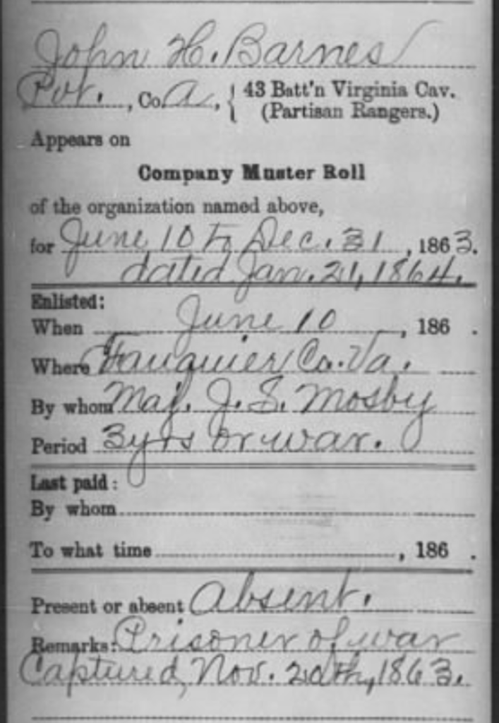
    John Barnes accompanied Mosby on the Fairfax Raid and suffered for it a week later when he was arrested on rightful and potentially correct suspicion of having guided Mosby and his men into the village. We know that Ames and Frankland were prominent in this process, but Federal authorities immediately targeted John Barnes—a paroled Confederate soldier whose family was concentrated at Hope Park, just south and west of Fairfax along the route Mosby used for ingress and egress.33

    Barnes was indeed a known quantity in this stretch of Fairfax County. In 1853, he inherited the Piney Branch Mill near Popes Head Run.34 This thread of professional association was potentially enough to knit one milling family into another. In the early-1850s, Barnes married Mary Isabella Fox, the eldest daughter of Gabriel Fox, the deceased owner of the Fox Mill complex that dominated Upper Difficult Run. 

    So it is that Barnes came into part ownership of Squirrel Hill. Today, this piece of remarkably resilient mid-18th century vernacular architecture has been integrated into a larger modern home on Lyrac Court in Oakton, Virginia. In the pre-war landscape of Difficult Run, Squirrel Hill was a prominent landmark. 

    Millers occupied unique roles in localized micro-economies of pre-industrial America. The Fox family of Difficult Run was no exception. They not only processed raw materials for distribution to wholesalers, but they themselves likely purchased raw grain and timber before it had been processed. They were necessarily of means and importance. 

    When he died in 1844, Gabriel Fox was described as enterprising and industrious, but also charitable. “Instead of speculating on the necessities of the people,” read his obituary, “he would forego an extra profit to supply the poor with bread.”35

    This focal existence radiated outwards from a constellation of mills that integrated with Squirrel Hill—the Fox family home. War-era maps show trails arcing up from the Ox Road through modern Willow Glen Court to the homesite off of Old Bad Road with similar routes carving their way to the lower mill on a path that traversed old native sites, crossed Difficult Run, and intersected with the Ox Road near Jermantown.

    Rich in ad hoc road connectivity, but reasonably distant from major thoroughfares, it’s no wonder that family lore connected to Squirrel Hill identifies the place as having served as a headquarters for John Mosby at some point during the war.36

    Jack Barnes, his wife Mary, and his brother-in-law, fellow ranger Frank Fox, sold the home in 1855, but the place knowledge likely never evaporated.37 

    After the war and potentially before, Barnes kept a small house near 11321 Waples Mill Road.38 The critical hint here is that Barnes joined the Mosby command at exactly the moment when the Confederates began to push south on the Ox Road (modern West Ox Road) toward Little River Turnpike. If Barnes were at Hope Park south of Fairfax, he would not necessarily have been privy to Mosby’s operations. However, Barnes was in Mosby’s ranks in time for the Fairfax raid and just after the fight at Thompson’s Road.39 This signals that he was living somewhere in and around Ox Junction at the time and would have been available to flesh out knowledge of Old Bad Road. In this way, Barnes was very likely the holder of connective place knowledge that united the spheres of Big Yankee Ames and John Underwood.

    Friends and Family

    Geography aside, John Barnes knit the social fabric of Difficult Run with the fate of John Mosby at a critical juncture. In the immediate aftermath of Mosby’s Fairfax Raid, Federal authorities cast a broad net for potential Confederate sympathizers in a wave of arrests.40 The neighborhood of Fox’s Mills on Upper Difficult Run was targeted with special zeal.

    Barnes, who was captured on March 13, found himself incarcerated with his brother-in-law Frank Fox, his step-father-in-law, Richard Johnson, their young neighbor Philip Lee, and another erstwhile neighbor, Albert Wrenn.41

    Paroled (again) on March 30, Barnes rejoined Mosby near Upperville. Upon his release in April, Frank Fox rendezvoused with his brother-in-law, Barnes, and added his name to Mosby’s rolls. Fellow captives Phillip Lee and Albert Wrenn joined that day as well. By July, Frank’s younger brother, Charles Albert, had enlisted. Minor Thompson, a near neighbor who had avoided the Federal sweeps, beat them to the punch by offering his services to John Mosby on the last day of March.42

    (Arrest notice from the March 18, 1863 Alexandria Gazette. LoC.)

    It is reasonable to propose that a cocktail of Mosby’s stunning successes against Federal cavalry, punitive Yankee arrests, and the example of John Barnes secured the support of the available young men in the Upper Difficult Run Basin.

    Though no other Yankees are reported to have followed Jim Ames to the Rebel side, the influence of both Barnes and John Underwood pulled Mosby deeper into Difficult Run and drew more and more local boys to Mosby’s ranks.

    Through the summer and fall of 1863, a trio of friends—Thomas I. Clarke, John Saunders, and James N. Gunnell—who lived near the intersection of modern Fox Mill and Stuart Mill Roads all made the pilgrimage west to join Mosby.43 James Gunnell’s brother, George West Gunnell, offered his services as well.44 The son of the Fox Mill school headmaster, Thomas Lee, joined his elder in service and three men of the Trammell family who were related to John Underwood by marriage joined him in Mosby’s fold.45

    These “friendly locals” who had grown up utilizing main roads and ad hoc desire paths lacing through the Difficult Run Basin were the fuel for a brief golden period of operations in the area between Ox Junction and Hunter’s Mill. 

    Mosby Country

    On March 18, Mosby observed the proposed contraction of Federal lines that walked the footprint of established Yankee pickets east of Difficult Run. They simply could not maintain the furtive posts on the Centreville and Ox Roads that Mosby had picked apart.46

    For over a month, Mosby was free to operate with near impunity in the area. This time frame coincides with bold actions taken on the part of John Underwood on the Lawyers Road corridor.47

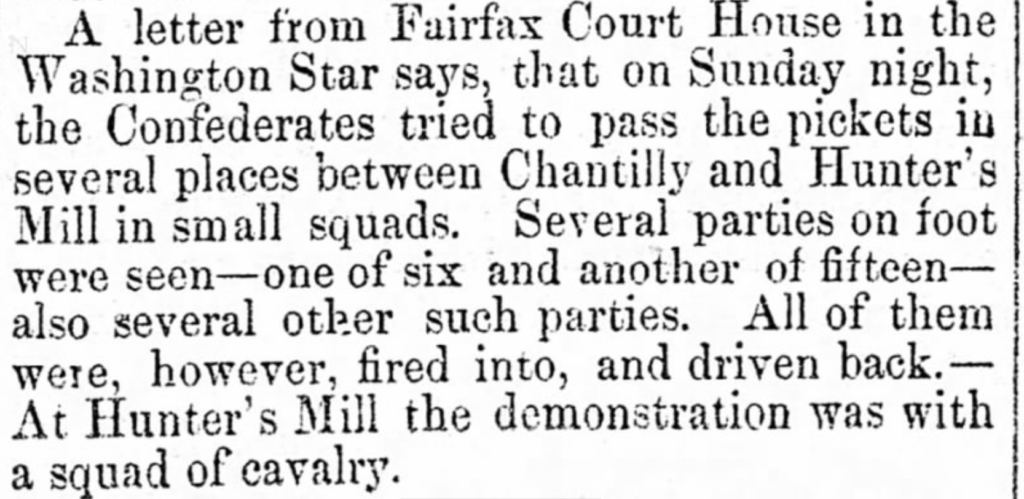
    In April, the local Federal cavalry commander, Julius Stahel, was instructed to cooperate with the Army of the Potomac’s proposed thrust over the Rappahannock. Mosby’s familiar adversaries were pulled from the Federal lines in Difficult Run and replaced by two regiments of infantry, the 111th and 125th New York. Under General Abercrombie, these foot soldiers held the Ox Road between Jermantown and Frying Pan.48

    Tasked with guarding the ridge line which Mosby had used to access the Difficult Run Basin from the vicinity of Horsepen Run, these Federal infantrymen experienced a number of scares as small penetrations by Confederate guerrillas became routine. 

    As the Alexandria Gazette reported on April 14, “Confederates tried to pass the pickets in several places between Chantilly and Hunter’s Mill in small squads. Several parties on foot were seen—one of six and another of fifteen—also several other such parties. All of them were, however, fired into, and driven back.—At Hunter’s Mill the demonstration was with a squad of cavalry.”49

    (April 14, 1863 Alexandria Gazette. LoC)

    Confederate partisans under John Mosby had already established the route into Difficult Run as a prime corridor for their operations. 

    In the last week of May and first week of June, Mosby began targeting large scale patrols on both Lawyers Road and the stretch of Ox Road that ran through Fox Mill. These operations are remarkable in both their scale and location. Grappling with and defeating company-sized elements of Federal forces required Mosby to predict his enemy’s arrival and funnel them toward a disadvantageous landform where they could be chewed up.50

    Mosby was apparently secure enough in his ability to operate within Difficult Run that he initiated these ambushes. So too, the Federal command took the potency of Mosby’s heightened threats in the area seriously. 

    By early June, the 6th Michigan was moved from Jermantown on the ridge above Difficult Run to Fox’s Mill itself.51 The position of an element this sized within the watershed itself is an important proof that substantial guerrilla activities were known to be occurring there. 

    Despite earnest attempts by coordinated Federals who operated in keeping with the best established military practices of the time, the ambushes and assaults continued. 

    On August 2, reports of rebel cavalry east of Fairfax began percolating. Yankee Brigadier General Rufus King instructed three separate union cavalry patrols to converge on Fairfax Court House. One party from Fairfax Station by way of Burke, another from Chantilly down the Little River Turnpike east, and a third from Fox’s Mill through Jermantown. These parties got word that a party of “30 or 40, with some 20 mules in their possession” had passed by, but the Union interception groups only witnessed two or three guerrillas at a distance.52 

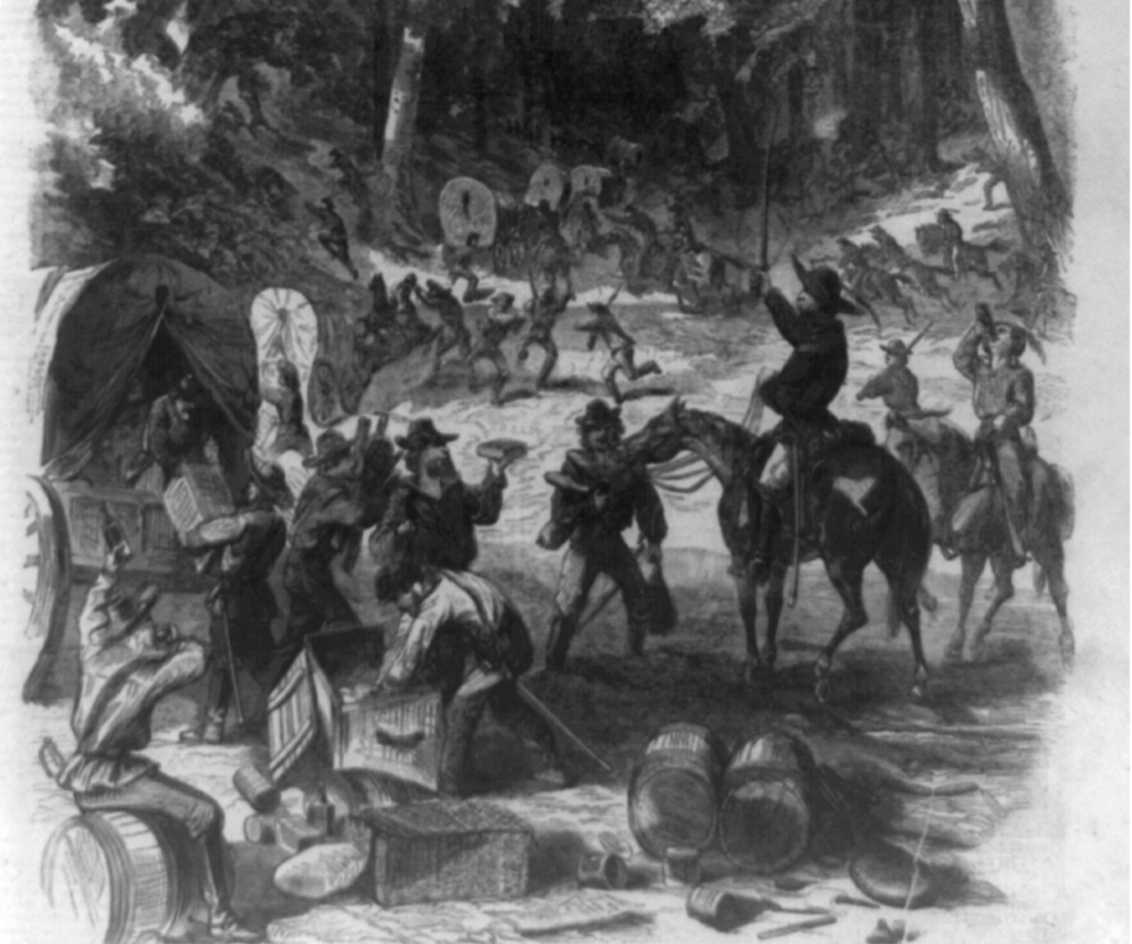
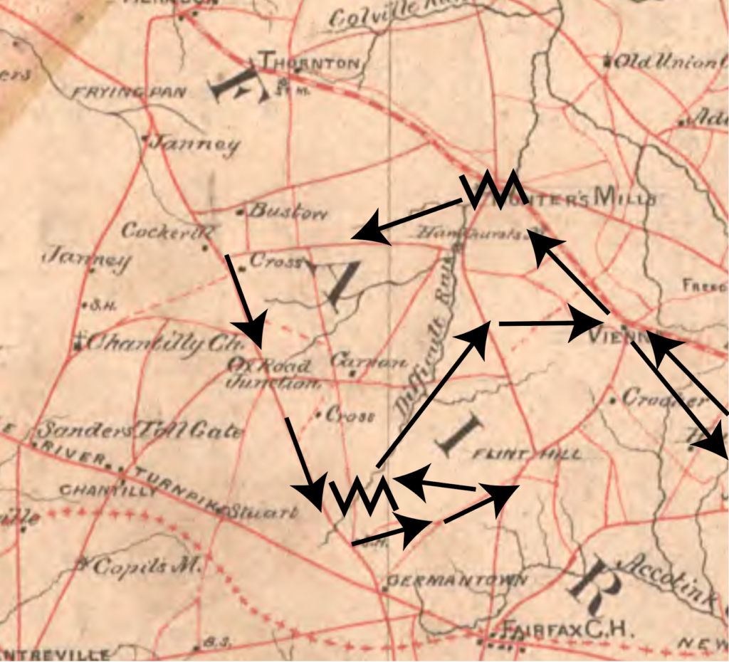
    Ten days later, Colonel C.R. Lowell, Jr of the Second Massachusetts Cavalry issued a perplexing report that chronicled John Mosby’s movements on a raid toward Annandale, east of Fairfax Courthouse. 

    “Mosby and White’s men—together about 140 strong—came down Little River Turnpike the day before yesterday, and passed that night near Gum Springs. Moved down yesterday forenoon through Ox Road Junction toward Flint Hill. Hearing that our pickets were there, turned to the north again, and, passing through Vienna by Mills Crossroads, to Little River Pike, near Gooding’s Tavern, captured one sutler’s train there between 3 and 4 p.m. and another about a mile farther east. An hour later, half plundered some of the wagons, took all the horses and mules, and started back in a hurry through Vienna, toward Hunter’s Mill.”53

    It is plain from both accounts that the Upper Difficult Run Basin had become something akin to a forward base for John Mosby. Its paths, trails, creek beds, draws, and minor roads had been coopted into interior lines that gave Mosby the ability to disappear at Ox Junction and reappear in Vienna on the other side. Or, alternately, Mosby could dissolve into the woods at Fox’s Mill and cut efficiently cross country to avoid a sizable Federal force moving at high speed toward him from the opposite direction.

    (Lowell’s account of Mosby’s maneuvers on August 8 translated onto an 1864 map produced by the Confederate Army of Northern Virginia’s Engineering Department. Arrows mark Mosby’s reported movements. Zig zags denote the end points of the critical interval of Difficult Run.)
    Nothing Lasts

    The heyday of Mosby as sole inheritor of the Upper Difficult Run began to wane as 1863 continued. Events conspired to thwart the Gray Ghost’s apparent haunting of the area.

    The Federal army utilized the ridge roads through and around Difficult Run as a conduit for their march across the Potomac before Gettysburg. Around June 16 and 17th, the Union 12th, 2nd and 6th Corps marched through Hunter’s Mill with the 1st and 5th following a line from Jermantown to Frying Pan.54

    In making preparations for the dispositions of the various corps of infantry and artillery that would push through the area, Dan Butterfield, Chief of Staff of the Army of the Potomac, passed to his subordinates the astute observation that “the country in the vicinity of Frying Pan is full of roads.” 

    He was correct, and, for once, those roads were in Federal possession. Though Mosby himself slipped through massed federal corps arranged around him in a road column during this same time period, it was an inopportune season for a raid—as his boss JEB Stuart discovered.55

    Less temporary than a passing formation of infantry, local commanders ordered the construction of a stockade in Flint Hill (modern Oakton) during the Fall of 1863 at the current corner of Chain Bridge Road and Blake Lane.56

    Not insurmountable, the stockade and its occupants did present a fresh hindrance to Mosby’s unbridled use of hidden interior lines on Difficult Run.

    What was insurmountable was the loss of irreplaceable locals who could navigate this warren of paths. The constant dwindling of Difficult Run men from hard service exacted a toll on Mosby’s ability to operate smoothly in the forests and bottom lands along the creek. 

    John Underwood was killed late in 1863.57  Big Yankee Ames died a year later, his knowledge of Union positions by then obsolete.58 John Barnes reentered Federal custody on October 22, 1863 during a failed raid against Annandale. Called a “celebrated guerrilla” by his captors, he remained a guest of the Federal penal system until war’s end.59 

    (John Barnes, POW)

    Barnes’ neighbor and prominent Difficult Run resident, Minor Thompson, was captured on June 12, 1863.60 In June of 1864, the Gunnell brothers were captured at a family home near Gum Springs.61 Then on September 5, 1864, Lieutenant Frank Fox, a capable commander and scion of the Fox milling family, was mortally wounded.62

    Albert Wrenn remained in Mosby’s service and brought much of his local familiarity to bear on forward operations in Fairfax County, but the want of good fighters in leadership positions forced Mosby to leverage Wrenn’s services farther and farther westward as a second front against Sheridan opened in the Shenandoah Valley during 1864 and 1865.63

    To make matters worse, a deserter from Mosby’s command—Charles Binns—began guiding Federal counter-insurgency patrols through Difficult Run. The enemy had acquired their own privileged place knowledge.64

    Mosby continued to utilize the Upper Difficult Run Basin throughout these setbacks. However, the results were never as cleanly executed nor as deeply flummoxing to his blue-clad opponents as they once had been.

    On September 15, 1864, for instance, Colonel Henry S. Ganseevoort of the Thirteenth New York Cavalry reported on a lengthy scout against Mosby that began with a night occupation at Fox’s Ford on Difficult Run.

    Gansevoort’s group encountered Mosby, but utilized a fresh familiarity with a perviously confusing maze of roads to intercept, aggravate, and ultimately stymie Mosby’s advance.

    “On the morning of the 15th of September it (his unit) resumed its march toward Fairfax, all indications and reports of scouts kept on the Centreville Road and roads to left of the turnpike tending to show that Mosby, with a large force, but in divided parties was on the left of the turnpike and between Vienna and Frying Pan. The scouts were driven from Flint Hill, but those at Fairfax reported that Mosby had been seen to pass through the Court-House toward Centreville a short time previous with two men. I dispatched five men to the Centreville Road, about three miles distant, to intercept the party, fearing that more men might fail of an approach. Near Germantown three of this number returned and reported a fight with Mosby, in which two of the men had lost their horses and had taken to the woods, and that large parties of guerrillas were now on the right. On the return of the other men it was definitely ascertained that Mosby, or a person resembling him, had been wounded and had escaped. Mosby had certainly been in vicinity of Fairfax just previous to the action and had gone toward Centreville. People on the road had seen him, and from the description of his person and recognition of his picture by parties engaged, there seems to be some color for the report that he was in the action and was wounded, as he or the person in question was seen before riding off to throw up his hands and give signs of pain. This could be observed, as the action was at very close quarters. I dispatched a squadron to the scene shortly after and moved to Fairfax Court-House, sending a party of thirty dismounted men through Vienna to Lewisville. The regiment reached camp at Falls Church after a march that day of fifteen miles from Chantilly.”65

    Despite positional ambiguity, a seasoned Federal force was able in September of 1864 to do what felt impossible sixteen months prior. They identified, tracked, contained, and reversed John Mosby along Difficult Run. 

    Five months later, a scout in force by Mosby subalterns William Trammell and Bushrod Underwood—themselves seasoned Difficult Run guerrillas—met defeat. Both flanks of Mosby’s forward operating base were no longer as opportunity rich as they had once been.66

    Even with these setbacks, the possibility of a Mosby attack was still enough to compel Federal forces to devote immense time and energy to the potential of an advance from this secesh-friendly and very dangerous corner of Fairfax County.

    As late as March 7, 1865, a group of gray horsemen surprised a squadron of federal cavalry from a cut near the stockade at Flint Hill.67 Mosby was still a factor until the bitter end.

    For simplicity’s sake, it’s important to hone in on the critical months between the raid at Thompson’s Corner on February 25, 1863, and the loss of John Barnes on October 22, 1863. Events as broader than these bookends, but the time between each date encapsulates a rich moment when the bridle paths of Difficult Run were masterfully manipulated in Confederate favor.

    A Guerrilla’s Eye For Place

    It’s worth taking a moment to consciously depart from traditional patterns of Civil War place memorialization. When we talk about John Mosby and his partisan rangers, we’re dealing with a type of warfare premised on landscape relationships that differed greatly from the locational psychology evident on typical battlefields.

    Men who hid and wove their way through lightly-populated, densely-vegetated landscapes to initiate brief and savage pistol fights on a weekly basis enjoy dissimilar memory of place than men who marched for weeks over known roads to array themselves by the thousands on open fields and hillsides that were the subject of medal awards, grand speeches, and lengthy tomes.

    To put a fine point on it: we’re not hunting for the place. There’s not going to be a Mosby Marker or a Mosby Trail. 

    What we’re searching for is an avenue, a constellation of paths, a batch of physical possibilities that account for John Mosby’s ability to disappear between Route 50 and Lawyers Road, West Ox and Hunter Mill Roads and either slink back to Frying Pan and Upperville or project farther eastward into Fairfax County. 

    There are quite literally thousands of places John Mosby could have been in Fairfax County at one time or another. Chronicling them all would be tedious. Understanding Difficult Run’s role in this geographic drama feels more essential, on the other hand, because of its repeated and obvious use as a staging area for prolonged guerrilla warfare in Fairfax County.

    Tracing the routes that enabled John Mosby to bedevil Federal Cavalry until war’s end is akin to shoving bones into the astral body of a ghost. It adds form and structure, something tangible to a thing that is otherwise ethereal. This process also demystifies John Mosby as an apparent wizard. Tying him to specific place patterns establishes links between Mosby’s much-lauded deeds and conventional military wisdom.

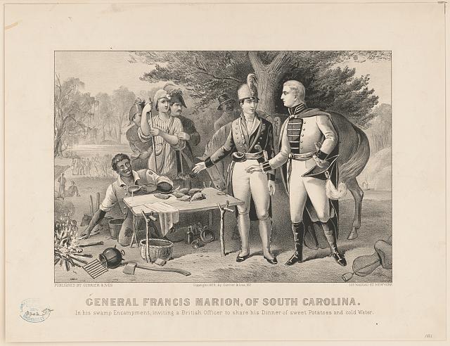
    John Mosby’s first hero was Francis Marion, the famous Swamp Fox of the Revolutionary War whose biography Mosby claimed was the first book he read for pleasure. In a sense, Mosby entered military service preprogrammed for the cunning use of bottom lands and bad roads.68 

    (Francis Marion, the Swamp Fox. LoC)

    The area surrounding Old Bad Road ignited Mosby’s deepest affiliations. Here was a place where Federal maps essentially advised their troops not to go, a place riven with forests and marshlands where a Francis Marion fan could reenact the Revolution. 

    Another important consideration—perhaps the consideration—is the fact that Mosby’s career as a cavalry scout framed his brain to judge landscapes for their applicability in maneuver warfare. As he did for JEB Stuart on his ride around McClellan’s Army, Mosby looked at infrastructure in Fairfax County with an eye for achieving superior travel time and surprise with massed formations of armed men.69

    Mosby’s storied career in Fairfax was received by friend and foe alike as an innovation in warfare. When in reality, he simply redressed Clausewitz, the lodestar military philosopher of the time, on a smaller scale. Slinking through Difficult Run on game paths and kid trails to appear where least expected was a tactic to maximize objective, offensive, mass, economy of force, maneuver, surprise, security, simplicity, and unity of command.

    The basin offered force multipliers in all of these respects. Especially noteworthy is the idea that Difficult Run was viewed by most conventional military minds as an obstruction to achieving mass and maneuver. With a force well-served by acute place knowledge and cut down to march cohesively in single file through narrow routes, a thicketed basin such as this became a gold mine of interior lines

    If the name is strange, the principle should be familiar. If a circle encloses an area, it’s easier and quicker for something inside the circle to move to the other side than it is for something outside the circle to trace around the outline and reach the same point. 

    The classical application in Civil War studies is the Federal fishhook position at Gettysburg, which bent around on itself, allowing George Gordon Meade to rapidly shift forces from one far end of his line to another in order to meet attacks. The Confederates, on the other hand, were stretched on exterior lines that made the translation of men from end to end a time-prohibitive hindrance. 

    With enough imagination and local support, Upper Difficult Run represented a tremendous opportunity for the use of interior lines. Over a span five and a half miles long as the crow flies, the creek touches or intersects four major thoroughfares that were in steady use by both armies during the war—the Warrenton Pike, the Little River Pike, the Old Ox Road, and Hunter’s Mill Road.

    If one knew and controlled the sub-roads therein, a small force could quickly dart between these four roads in a fraction of the time that a pursuing Federal contingent ignorant to those routes could lace their way around to the same point on major roads.

    Criteria For A Guerrilla Base

    Identifying the bridle paths that served as interior lines for the movement of John Mosby’s guerrillas requires a fine-honed set of criteria. It’s essential to grapple with the existing landscape conditions could have been readily converted to irregular military use in 1863. By balancing what was available and what was useful, we can chart a new map of the Upper Difficult Run Basin. 

    These five criteria are the basis of that work. Any single one of these factors could have been alluring to Mosby and his men, but the sites where multiple criteria are met deserve particular attention.

    1. Did the area have desire paths that connected one or more destinations not served by an exiting road or did it offer an alluring shortcut?
    2. Did this axis follow prehistoric dimensions where paths of least resistance connected local highland forests with marshy bottoms or lithic deposits? 
    3. Did this path cut across Federal lines or achieve some adjacency from which men could quickly breach Yankee-held roads?
    4. Was the area in friendly possession? Ie: were the people that lived there Confederate sympathizers, families of Mosby men, or absentee yankees?
    5. Was this route invisible? Was it hidden by some feature of nature or man-made endeavor that made it a less than obvious place to hide?

    The logic deserves some explanation.

    Desire Paths

    The bane of urban planners, desire paths are unforeseen and unsanctioned shortcuts that people choose over formal routes. Think of a foot-worn trail cutting across the corner of an otherwise pristine lawn. Landscapes are strewn with just such paths that connect people and animals with the objects of their desires. 

    Dan Butterfield’s observation in June of 1863 that the area around Frying Pan was “full of roads” offered unknowing clarity regarding the development of farms and roads in the neighborhood of Upper Difficult Run.70

    No courts, ports, markets, or taverns were historically located within the basin. Institutions sat elsewhere, in distant places that each landowner or tenant was incentivized to reach on their own and with the least amount of hassle. 

    Fifty years after the war, school-aged kids living in Vale—the postwar hamlet that sprouted up on Fox Mill Road near its intersection with Old Bad Road—preferred to thread across fields and forests than take established roads to high school in Oakton.71 

    (Desire paths, in theory at least. 1912 topographic map)

    Widely-accepted and even encouraged, this practical place negotiation was probably a long-standing tradition in the area. In fact, the roads these students avoided were the very same routes on which Federal forces couldn’t find Mosby and his men fifty years prior. Moreover, the high school they attended was located in the same vicinity as the federal stockade on Chain Bridge Road, which was long a target for Mosby and his men.

    The question then isn’t focused on the existence of desire paths in Upper Difficult Run, but charting destinations which would have compelled locals in the pre-war era to beat new paths over hill and dale. 

    The most obvious candidates for local, informal trail-making were the mill complexes. Beginning around the time of the Revolution, six counties of Northern Virginia were the state’s chief grain producers, accounting for 70% of wheat output.72 This infrastructure magnetized farmers across this region with both economic and social incentives.

    Upper Difficult Run was nowhere near as productive a breadbasket as Fauquier County, but nonetheless, huge swaths of the local economy oriented itself to grain markets in Alexandria. From a geographic perspective, these resource flows were unlike tobacco production, in which individual farmers dried and barreled their leaf before rolling it wholesale to ports.

    Instead, complex and robust microeconomics developed around local topographic minima where significant drop in creeks and capital investment collided to facilitate the establishment of grain mills. 

    A successful milling operation like Fox’s Mill or Hunter’s Mill inspired a radial network of informal paths on which timber and raw produce carved deeper traces with each passing harvest. Dragging timber to a milling site will leave a mark. 

    The explicit economic necessity of these mills represented a fraction of their allure. They were essential gathering spots—places where neighbors could gossip, collect mail, spread news, or simply leave the farm for a few minutes.

    It was a phenomenon beyond the boundaries of Difficult Run.

    Nan Netherton wrote of the early-1800 mill-boom in Fairfax County, “the water-powered mills often spawned new communities as other merchants began to locate near the mills. New roads were cleared at the end of the eighteenth century in the interior of Fairfax County to provide access to the mills.”73

    (The 1864 Michler Map sites all four pre-war mills active along Upper Difficult Run. LoC.)

    The community aspect was complex. People forged routes to mills for a variety of reasons. One quiet motivator was stated explicitly in the obituary for second-generation mill owner Gabriel Fox, who died on August 28, 1844. Gabriel’s father, Amos, founded Fox’s Mills on Difficult Run. After his passing, Gabriel consolidated ownership over the mill and developed it into a prime property. 

    Upon his death, the dimensions of his success became more obvious to posterity. It is clear that Gabriel was no mere miller, but also a speculator and wholesaler who made a small fortune in purchasing raw grain directly from producers before transporting it to Alexandria and cutting his own lucrative deal with flour exporters. 

    The arrangement put Gabriel Fox and his family in the position of being able to both lend money and render assistance in times of need. As his obituary makes clear, Fox’s Mill was a place where the less fortunate could find relief in hard times. 

    His obituary in the Alexandria Gazette records that, “He will be much missed by the poorer class of people in his neighborhood.—His course toward them in many points are well worthy of imitation by those having the ability. For instance, in the latter part of the summers when corn was scarce, and the waters low, and persons of property would come to him to engage him to supply them with meal, perhaps offering him an extra price, he would tell them you have means to purchase with, go elsewhere and buy; I cannot more than supply those of my customers who have not the means of procuring from other sources. Thus instead of speculating on the necessities of the people, he would forego an extra profit to supply the poor with bread.”74

    If charity wasn’t incentive enough to orient all desire paths towards local mills, strong drink was. The correlation is obvious: mills were sites with an abundance of grain that was underscored by capital liquidity and sharp entrepreneurial instincts. Of course they manufactured alcohol. 

    In 1816, Amos Fox posted a notice in the Alexandria Herald seeking to either sell outright his prime distillery at Fox’s Mills or hire a good distiller. The still was “within three hundred yards of two mills” and featured “plenty of water running over head” and “mash tubs.”75

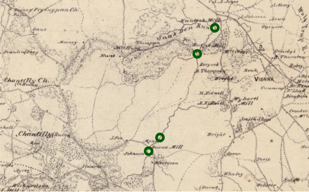
    Four and a half miles north of Fox’s Mills and a quarter mile east of Hunter’s Mill in a secluded and very deep micro-valley along Angelico Branch, a local rogue named Charles Adams ran a mill-adjacent grog shop that highlighted the less respectable aspects of these communities. 

    Hunter’s Mill and its surroundings was more rough and tumble in the 1850s than Fox Mill. The arrival of the railroad brought strangers and outward economic influences into a community that was past its prime. People also made their way to Hunter’s Mill for a variety of lurid reasons. Lethal card games, accusations of prostitution, and heavy drinking shaded the area’s reputation. 

    Charles Adams only added to the area’s unsavory reputation. Adams attended the secession vote with a drawn pistol to intimidate Unionists. When he was arrested two years later as a Confederate spy, his reputation as “a perfect desperado, drinking and fighting, stabbing and shooting” preceded him. Most ignominiously, his wife of four years divorced him in 1852 because he had seduced and taken up with her sister. Classy stuff.76

    (Beyond the moral dilemmas inherent to human slavery, this reward notice suggests an even deeper layer of moral bankruptcy on the part of its author, Charles Adams. The Hunter’s Mill resident posted this item in the December 17, 1855 edition of the Evening Star. Adams’ runaway, a delicate 5’2″ woman with a “copper” complexion, skedaddled from the Adams property with a six month old baby who was “nearly white.” We know two things definitively: 1. Charles Adams had no compunctions about treating white women–specifically his wife and her sister–as objects and 2. he belonged to and defended a society steeped in a racial hierarchy that handled people of African derivation as less-than human. From these items, it is not difficult to believe that this ad was drafted to secure the return of Adams’ concubine and bastard child. )

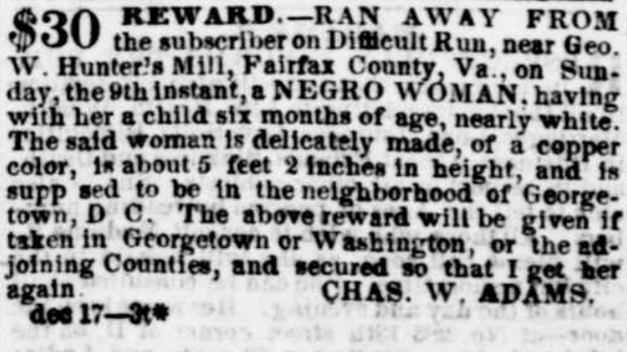
    In June of 1860, the Commonwealth of Virginia opened a case against Charles Adams. It seems he was operating a grog shop out of his hidden home near Hunter’s Mill. There he retailed “wine, rum, brandy, and whisky” to both slaves and free blacks.77

    Rough and rowdy Hunter’s Mill and its more buttoned-up competitor, Fox’s Mill, represent opposite ends of a stream valley corridor that was unserved by major roads along its long axis. 

    Whether for business or for pleasure, it is a reasonable assumption that desire paths sliced through this critical interval to bring locals to mill centers for a variety of purposes.

    An 1856 advertisement posted by Madison C Klein to entice someone to purchase adjoining tracts of land on Difficult Run touted the use of creek-adjacent meadows and fields for fertile farmlands. More importantly, though both of these tracts bounded Hunter’s Mill Road, the selling point for mercantile accessibility was their proximity to Difficult Run itself!

    “These lands are undulating, with sufficient bottom for meadows, well watered, having several never failing springs of pure water thereon, and bounded on the west by Difficult Run, on which there are merchant saw-mills of convenient access.”78

    This “convenient access” could only mean desire paths or game trails or bridle paths that darted along the creek valley floor itself.

    In short, there were unsanctioned, informal roads that cut along Difficult Run enabling residents in the valley between the mills to access either end.

    Proof positive comes in dubious fashion in the form of the 1937 Fairfax County aerial survey of the area. Though anachronistic to Civil War studies, the territory between Fox’s Mill and Hunter’s Mill is laced with little white fissures, each a well-worn trail.

    (Trails along and across Difficult Run on and near the former Madison Klein property. From aerial photography taken April 19, 1937.)

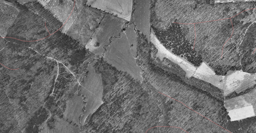
    One tracks along Difficult Run, another parallels it from the comfort of shade near the treeline. Still other and more prominent paths cross these first two and connect upwards into draws that cup downwards and transition gently into the plateaus above. 

    In a county that embraced dairy farming after the Civil War, such paths must be questioned. 

    Did cows or horses or men or deer carve these? When?

    Nonetheless, the patterns they exhibit tell a striking story of connectivity. These trails were fascia, connective tissue between meaningful places where weary farmers’ feet and drunken stumbles could have found the path of least resistance to or from home.

    Prehistoric Dimension

    The presence of numerous prehistoric sites within or adjacent to the critical interval between Fox’s Mill and Hunter’s Mill on Difficult Run adds literal depth to the notion of abundant desire paths facilitating Mosby and his men.

    In Virginia, archaeological sites (their whereabouts, and their contents) are considered “sensitive and protected.” However, the existing public record and other less obvious sources point to a rich history of human resource extraction—be it mineral, vegetable, or animal—in Upper Difficult Run.79

    Evidence suggests that indigenous people occupied the space dating back as far as 6000 BC. This prolonged timeline bridges sustenance paradigms to encompass two very different land-use strategies. Unsurprisingly, today’s Oakton once hosted seasonal gathering camps which found native people establishing themselves temporarily on local highlands overlooking Difficult Run where they could gather the acorns and nuts that fell from oak, chestnut, and hickory trees. Later advancements in caloric acquisition found the descendants of these first people utilizing floodplains to source or cultivate plants like chenopod in an early attempt at agriculture.

    The Difficult Run of this era would have looked very different from the area John Mosby utilized during the Civil War. Fire regimes encouraged the ascension of mast-producing trees and cleared secondary growth to enable both hunting and some agriculture.80

    Once established, natives would not have needed a John Underwood to guide them through obscure thickets. Fire would have pre-cleared the brambles. Still, a few truisms of human-landscape interaction are universal. Early human axial relationships found native people cutting across and traveling longitudinally along the same areas of Difficult Run that facilitated these same motions in the 19th century. Thicket or not, the first people to make these moves would surely have found the paths of least resistance up, down, across and through in ways that patterned, formalized, and literally terraformed the earth to create more or less permanent grooves. 

    Adding complexity to this theory of path genesis is the fact that both the Chain Bridge and Hunter Mill Road were both known indigenous roads that traversed the Potomac River and traced across ridges to intersect in what would become Oakton. It is unlikely that the nexus of these two prehistoric trails had nothing to do with the prominent deposit of highly sought after white quartz on Marbury Road off Hunter’s Mill Road less than a mile east of Difficult Run in its critical interval. 

    (Broad indigenous potential–as described by items former County Archaeologists have left in the public record at the Fairfax County Library.)

    Tool-making stones, creekside foodstuff, forest forage, and game all incentivized prehistoric people to beat trails across the landscape between the future Fox’s Mill and Hunter’s Mill. There is a pedigree—obvious or not—to the bridle paths that laced through the area during the Civil War.

    (For more on indigenous roads, see this post.)

    Proximity to Federal Lines

    If presence of ad hoc roads with intermixed native significance were the only criteria, then it would be difficult to eliminate any of Northern Virginia from consideration as a funnel for Mosby’s forces. 

    One essential qualifier to the place puzzle at hand is proximity to Federal lines. 

    First and foremost, John Mosby and his Rangers required cunning routes with which to bypass established Yankee outposts and patrol lines. After the initial success of his raids in early 1863, the wide net cast by Federal forces in western Fairfax County contracted to a more reasonable dimension just west of Fairfax Courthouse.81 

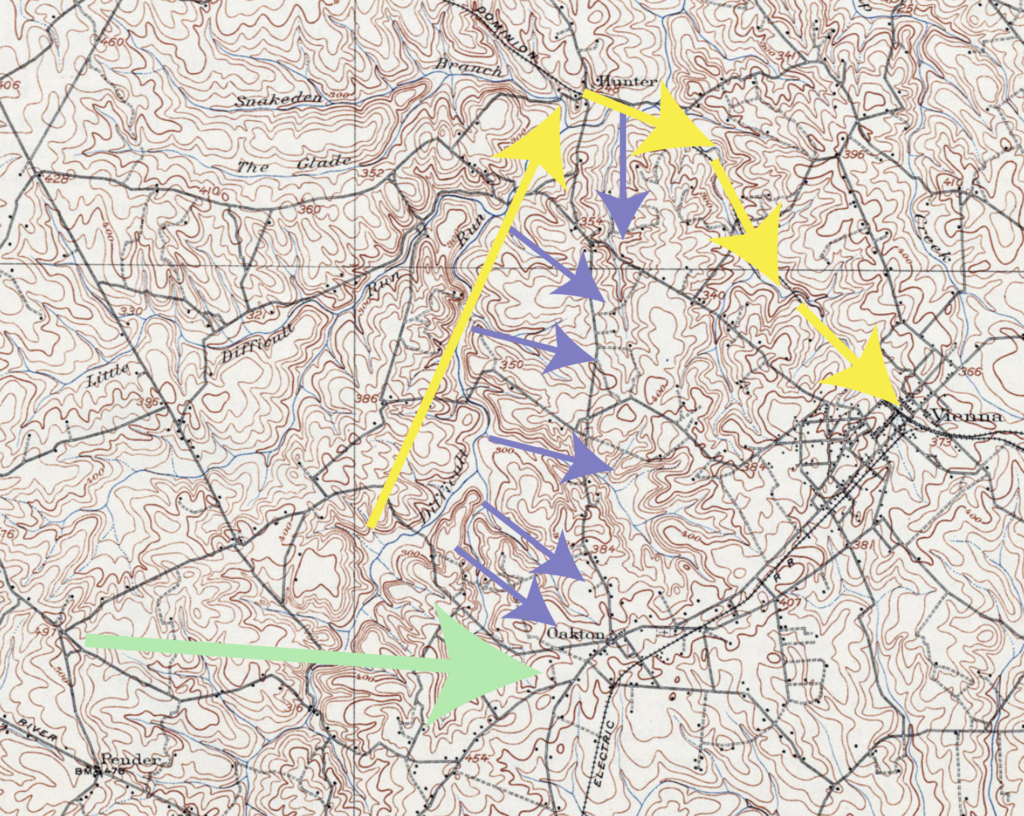
    Early ambushes along Horsepen Run near Frying Pan and along today’s West Ox Road were overlooked until John Mosby and his men penetrated Fairfax Courthouse and captured General Stoughton. In the aftermath of that raid, Federal lines seemingly acknowledged the unpatrolable nature of Difficult Run by establishing the main line of occupation just to the east on a line stretching from Jermantown up to Flint Hill, Vienna, and Tyson’s Corner beyond. 

    From this position, heavy contingents of Federal cavalry struck out along major corridors like Hunter Mill Road, Lawyers Road, the Old Ox Road, and the Little River Turnpike. Difficult Run intersects all of these major thoroughfares. 

    More importantly, the critical interval of the creek stretching between Fox’s Mills and Hunter’s Mill would put John Mosby and his men within a short ride of each of these corridors while providing easy access to the main line of Federal cavalry guarding Fairfax. 

    The brilliance of the position Mosby occupied on Difficult Run was its relative wealth in interior lines that were unsuitable for the bulky road columns utilized by his pursuers. Operating in single file or in a herd-like cluster, Mosby and his men could dart across fields and forests and outmaneuver Federal units who would arrive at the same place in twice the time.

    This process is more than a hypothetical. It’s quite likely an operational model for how Mosby and his men seemingly disappeared at Ox Junction, made contact with yankee pickets at Flint Hill and then dipped into the woods only to cross over Chain Bridge Road at a point north. 

    Reciprocal proof is available in the form of multiple after-action reports that place Mosby’s Rangers east of Fairfax, near Annandale, and skulking about in the woods of Accotink Creek. 

    Established on October 1, 1863, Company B of Mosby’s Rangers was created in no small part to hunt into this forward operating area. Its First Lieutenant, Frank Williams, had privileged local knowledge.82 

    Frank Williams, grew up on four hundred and twenty two acres in Vienna right on the Alexandria, Loudoun and Hampshire Railroad just east of Chain Bridge near where the Whole Foods is today.83

    (Frank Williams’ boyhood home pictured at to bright. Fairfax County 1860 Property Map, square 38-4. Courtesy of the Honorable Christopher J. Falcon, Clerk of Court.)

    An anecdote from James Joseph Williamson in his account of his years riding with John Mosby shines light on the psychogeographic dimension of Frank Williams’ attempts to marry his sense of home with his duties as a Ranger Lieutenant. 

    “Thursday, October 22—Lieutenant Frank Williams was ordered by Mosby on a scout inside the enemy’s lines in Fairfax. This territory was in close proximity to the Federal capital and well guarded at the time> he selected for his companions John H. Barnes, Robert M. Harrover, Dr. T.E. Stratton and Charles Mason. They struck the carefully guarded Federal picket line along the Vienna and Fairfax Court House road, and under cover of darkness passed through without giving an alarm. They were now in the enemy’s country, but in the vicinity of Williams’ home. Feeling quite safe and anxious to learn all possible of the situation he decided to call upon an old family servant. This old slave was true to his master and the cause of the South. They approached the house about midnight. It was dark and still. They were miles from their comrades, in the midst of a hostile country. Suddenly they rode right into an encampment, not being able to see the tends until they could almost touch them. Slowly and cautiously they withdrew and attempted to reach the colored man by another road. They had proceeded but a short distance when they were met with the command ‘Halt!’ and a volley of musketry at close range. They again had to retreat, but not before Harrower gave the enemy a parting salute from his revolver, the only shot fired by Williams’ party. Being anxious to see the old colored man they made another effort to reach him, and in crossing the Alexandria and Leesburg Railroad another volley was fired at them. Under these conditions they concluded to postpone the visit and strike out across country to Annandale, on the Little River pike….From a position where they had a view of the pike they saw a number of horses grazing; also a body of cavalry not far distant. After consultation they decided to withdraw, secret themselves in the timber, return under cover of night, and make off with as many horses as possible.”

    Almost off-hand, Williamson offers valuable proof of Difficult Run’s importance in Mosby forward operations during 1863. In seeking to find his way across “the carefully guarded Federal picket line along the Vienna and Fairfax Court House road” ie: the Chain Bridge Road located on the ridge just above and to the east of the critical interval, Frank Williams solicits the help of Jack Barnes, a man with intimate connections to and knowledge of the section of Difficult Run above Fox’s Lower Mill where the raiding party would slice through Yankee videttes. 

    The account goes on to describe a failed attempt to outride Federal cavalry on the following day, which led to Williams being unhorsed. After a day spent cutting through the landscape to dip into friendly lines, Williams arrived hatless the next morning at the nearest friendly landmark—Hunter’s Mill at the northern limit of the critical interval of Difficult Run. There he “received a hearty welcome, a good breakfast and a Yankee cap.”84

    These places were familiar to Frank Williams. He wove his duty as a Confederate officer into the unique gravity of his home and existing social relationships while falling back on adjacent friendly landscapes when times got tough.

    Beginning in October, Mosby and his men struck toward Alexandria on the Little River Turnpike and into Annandale.85 These bold attacks represent an integration of Williams’ place knowledge into command operations and an obvious tying of these territories into the existing adjacent corridor of advantage. 

    Our critical interval of Difficult Run was three miles from the home in which Frank Williams grew up. In mid-1863, a stiff line of Federal resistance separated Mosby from these happy hunting grounds. Its ultimate utilization speaks to the fact that Mosby was incentivized to find a way to exploit Federal lines in the area nearest Williams’ homes. 

    Still more intriguing is the notion that our section of Difficult Run provided multiple proven means of ingress and egress for small units of Confederate partisans to slip past Federal lines. 

    Three obvious corridors of opportunity bridge the line of desire paths along Difficult Run with Confederate objectives east of Hunter’s Mill and Chain Bridge Roads. 

    1. A direct route from Difficult Run up and through modern Miller Road or Samaga Drive offers immediate access to the intersection of Hunter Mill and Chain Bridge Roads. Heavily travelled by Federal forces, John Mosby famously frequented the area as well. At that crossroads, a dominating oak tree rumored to be the inspiration for the place name “Oakton,” was long known as the Mosby Oak, because John Mosby attempted to capture Yankee-born Sully Plantation owner Alexander Haight there on August 29, 1862.86
    2. Low and slow, Mosby and his men could have ridden through the low profiles of Difficult Run or its many tributaries like Rocky Branch, Piney Branch or Angelico Branch, to achieve a custom, if cumbersome route across Federal lines.

      In his poem “The Scout Toward Aldie,” Herman Melville describes the paranoia-inducing combination of dense foliage and broken terrain that made this stretch of the Federal line a nightmare to defend.

      “They pass the picket by the pine
      And hollow log — a lonesome place;
      His horse droop, and pistol clean;
      ’Tis cocked — kept leveled toward the wood;
      Strained vigilance ages his childish face.
      Since midnight has that stripling been
      Peering for Mosby through the green.”87
    3. Quickest still, if not less direct, was the isolated avenue provided by the defunct Alexandria, Loudoun and Hampshire railway. Whether the track was torn up early in the war or during the Antietam Campaign is a matter of some small controversy.88 What’s clear is that the railroad was out of operation and its bed available to other uses by the time Mosby arrived in town. Though slightly out of the way, its path would have taken a direct line to Frank Williams’ father’s property and to the host of hyper-local place knowledge that that spot provided.
      Crucially, we know that Mosby Men felt very comfortable operating with impunity on the stretch of railroad bed nearest to Difficult Run by Hunter’s Mill.

      During a raid into Falls Church on October 18, 1864, Captain Montjoy of Mosby’s command detected a rabid Unionist blowing a horn to alert the Federal home guard of the Confederate presence. The culprit was the Reverend John D. Read.89

      The Rangers took Read and a freed-slave named Frank Brooks captive and summarily executed them by close pistol shot on the tracks of the AL&H Railroad within a few hundred yards of Hunter’s Mill.90

      Though Brooks survived to tell the tale, John Read was good and dead. In their guide to Mosby sites in Fairfax County, Charles Mauro and Donald C. Hakenson describe meeting an Oakton old timer who remembered local school children jumping rope to a rhyme about John Read’s demise nearby.

      “Isn’t any school
      Isn’t any teacher:
      Isn’t any church,
      Mosby shot the preacher.”91
    (Potential # 1 in green. Potential # 2 in lavender. Potential # 3 in yellow.)

    The larger point is that Mosby and his men obviously utilized corridors immediately east of the critical interval of Difficult Run to slip through Federal lines. Besides terrain and pre-existing path advantages, the Gray Ghost used this particular area because of another obvious fact.

    Friendly Control

    The proverb of the Reverend John D. Read teaches that proximity to Federal lines could be a problematic proposition for both parties. Any inkling of divided loyalties courted disaster. Rebel partisans faced capture. Unionist civilians faced possible death. 

    These dynamics lend weight to the theory that Upper Difficult Run was a viable corridor for Confederate partisans. This conclusion is the fruit of a prolonged spatial analysis that was only recently made possible by a wealth of cartographic GUIs, graphic design tools, and digital records.

    Below is a map that represents many dozens of hours of my time. Its base layer is an 1860s property map that that immensely talented and passionate historian Beth Mitchell painstakingly cobbled together by taking colored pencils to the Fairfax County 1981 Real Property Identification Map.92

    The detail is so granular and the map is so large that a single working, zoomable version has never been hosted online. In December of 2022 and January of 2023, I screen-capped every individual panel in or adjacent to Upper Difficult Run, trimmed it, and pieced them together into a single map.

    (The Upper Difficult Run portion of Beth Mitchell’s 1860 Property map cobbled together by yours truly.)
    (Records overlay of the Upper Difficult Run section of the 1860 Beth Mitchell map. Light gray indicates a yes vote for secession. Blue indicates a nay vote. Dark gray indicates Confederate service in the household of ownership. Mixed blue and gray denotes divided ownership.)

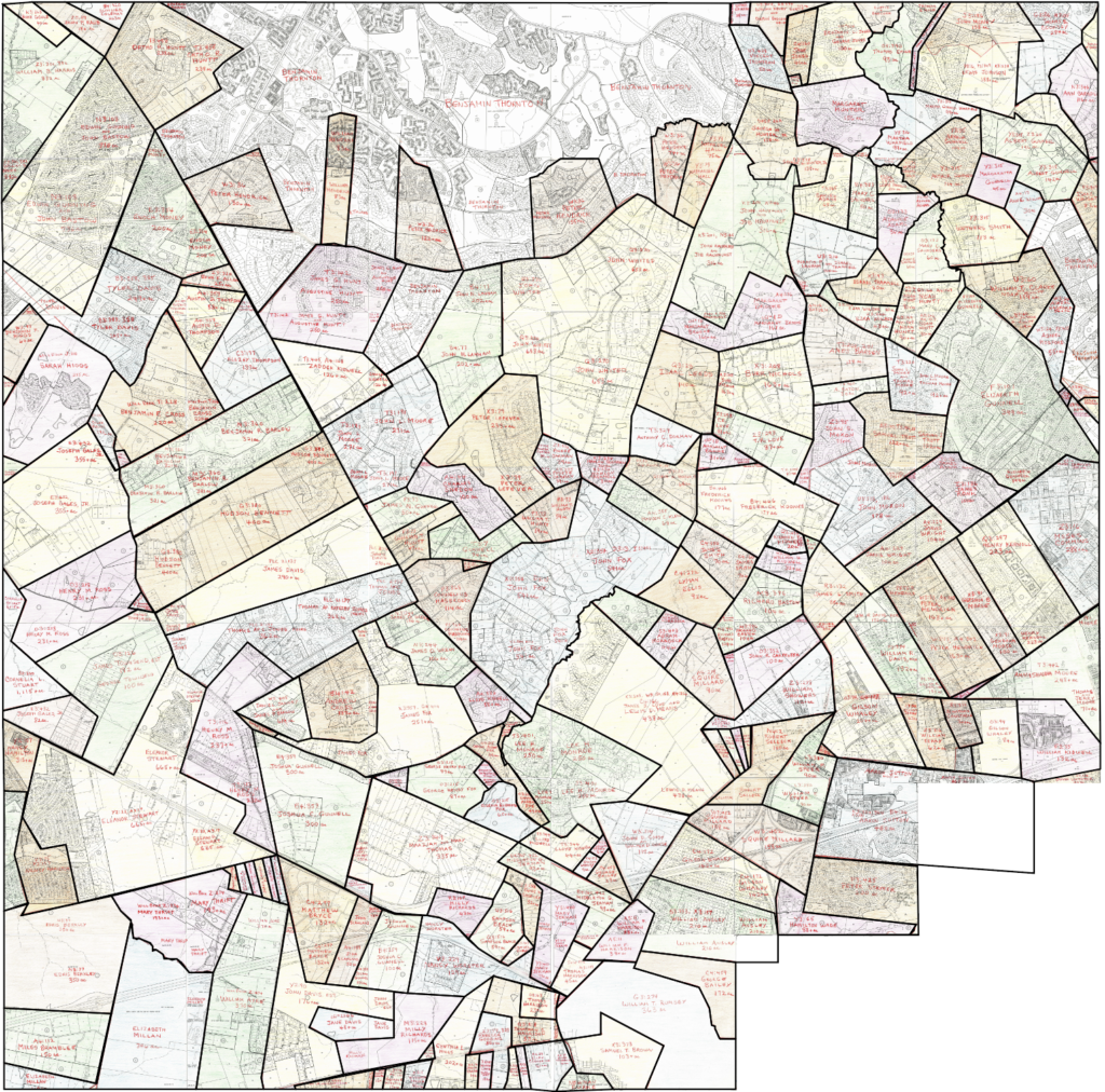
    Then I went through this monstrosity and diligently recorded every property owner and the map codes identifying which squares of the map correspond to their holdings. For nine months, I agonized over local genealogy. Ancestry, Family Search, wedding announcements, single-family genealogical monographs in the Historic Society yearbooks, census records, deed books, chancery documents, et cetera. I hit them all more than once. 

    The prize at the end of this tedious process was the resolution of illusory distortion in the Mitchell 1860 Property Map. These were not discrete parcels. Rather, the property lines represented legal boundaries that blurred and morphed over time to disguise elaborate kinship networks.

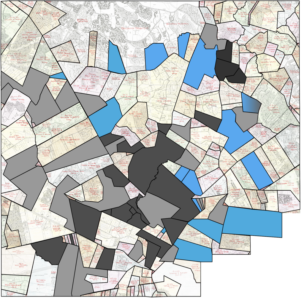
    Next, I parsed these kinship networks through Fractured Land, Brian A. Conley’s compilation of the 1861 viva voce secession vote.93 This allowed me to stylize individual parcels in either light gray or light blue to indicate the way the owner voted. Then I cross referenced William Page Johnson, Jr.s’ Brothers and Cousins: Confederate Soldiers & Sailors of Fairfax County, VA, as well as the National Soldiers and Sailors Database, and the roster appendices to the 43rd Battalion Virginia Cavalry, 8th Virginia Infantry and 17th Virginia Infantry histories to determine Confederate service.94 

    This last detail enabled me to deepen shades of gray in instances where property owners both voted for secession and someone in their immediate family (father, son, brother) was in Confederate service.

    The results are very intriguing. A deep swath of heavy gray reflecting pro-secession votes and Confederate service cuts through the Difficult Run valley between the Little River Turnpike and Hunter’s Mill. Even more noteworthy is the presence of blue marbled throughout the area. 

    My built-up map has problems. To wit, I cannot account for tenancy or owner occupation. It’s extremely likely that more Mosby Rangers lived in the area at the time. Specifically Clarke and Saunders, whose descendants later claimed that the two boys, along with their good friend, John N. Gunnell, all left their homes near the intersection of current Fox Mill Road and Stuart Mill Road to join Mosby.95 

    More noteworthy still is the presence of multiple Unionist votes marbling through the valley. In her contributing chapters to the definitive Fairfax County History, Patricia Hickin claims that “by 1847, some two hundred Northern families, averaging six members to a family had moved into the county.” The end sum of this population influx was that a third of the white male population in Fairfax County was northern-born by the outbreak of the war.96

    In some local precincts like Ross’ Store or Sangster’s Station where future Mosby Rangers Frank Fox, Minor Thompson, and Jack Barnes voted to leave the Union, secession was a near-unanimous position.97 This accounts for the massive gray pocket.

    However, the splotchy blue along Lawyers Road and around Hunter’s Mill was represented at the polls in Lydecker’s near Vienna where Yankee sentiment was bold enough to rebuke the southern cause and vote against secession.98

    Blank spots on the map where the original 1860 property ownership bleeds through without a clear indication of either pro or contra secession sentiment speak to another distortion. A culture of voter intimidation at the secession vote may have stymied accurate representation of northern sympathies.99 Many of the names near the critical interval—Isaac Leeds, Phoebe Carman, John Whited, Richard Bastow, and Frederick Koones were known Yankees.

    This last issue raises a more significant question: did anyone of Yankee birth or Unionist inclination remain in the valley during the war? The answer is most likely no. 

    If political intimidation at the polls was incentive enough not to vote, then the pressure-cooker of anti-yankee violence that emerged in this district of Fairfax County would have been compelling enough to encourage a rapid exit.

    A news item from the Alexandria Gazette dated November 9, 1860, details the assault of a man named “Gartrel” who cast a ballot for Abraham Lincoln. The Republican voter was “seized by a party while he was coming out of the Court-house and carried a short distance from the village, where he was blacked completely with printer’s ink, mounted on his horse and started for his house.”100

    Many took the hint, including Job and John Hawxhurst—the area’s most prominent Yankee landowners and staunch Quaker Unionists. John became a local delegate to the absentee Unionist government of Virginia from the safety of Union lines.101 Left untended during the war, their mill along Lawyer’s Road at its intersection with Hunter’s Mill Road became a favorite haunt of Mosby guerrillas.102 Along Old Bad Road, the nearby property of their sister’s husband, Isaac Leeds, was most likely abandoned and conceded.

    Beginning with John Brown’s Raid on Harpers Ferry, a culture of suspicion heightened. Yet, many Yankees were able to withstand the outbreak of hostilities and remain in semi-occupation of their farmers. That mostly changed with the arrival of the Army of Northern Virginia in August of 1862. Preceding the gray-clad infantry was a cloud of cavalrymen who sought to arrest anyone suspected of harboring anti-Confederate positions. Men like Sully Plantation owner Alexander Haight fled western Fairfax County “by cutting across fields and keeping to seldom-used byways.”103

    Two prominent northern-born landowners who lived east of Hunter’s Mill Road between Difficult Run and the Federal lines left the area for the duration of the war. Their testimonies to the Southern Claims Commission chronicle intense material losses and a stiffer sense of urgency connected to their departures.104

    In May of 1861, a pro-Union resident of Vienna penned a letter to a friend in New York, in which he described a neighborhood that had passed a threshold from harsh words to violence. “Men are persecuted and threatened with violence and even with hanging for wishing to cling to that government which has protected them in their civil and religious liberty, which has thrown over them and around them a halo of Freedom and prosperity that no other government under heaven has,” wrote B.S. Carpenter.

    He went on to describe an attendant mass exodus of Unionists. “Thirty four families left Vienna in two days with what they could hastily gather up and then bid adieu to their homes for which they have toiled to make comfortable and pleasant.”105 In short, the country was quickly emptied of Yankees.

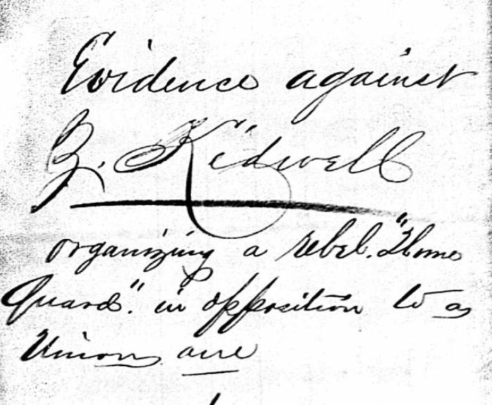
    Deeper in Difficult Run, even native Virginians born into deeply-entrenched local families were likely not spared the wrath of their neighbors. John Moore, a descendent of Difficult Run Baptist preacher Jeremiah Moore and owner of the land east of Fox Mill Road immediately across from Bennett Road, voted for Virginia to stay in the Union. This made him the sole Unionist between Lawyers Road and Little River Turnpike in the area of Fox’s Mill.

    Little is known about the consequences he faced for his vote, but the arrest of his immediately adjacent neighbor, Zadoc Kidwell, for a plan to create a Confederate Home Guard and strike out against Unionists probably did not bode well for Moore. At very least, any thoughts of rendering aid to Federal forces were likely curtailed.106

    (Zadoc Kidwell’s appearance in the Provost Marshall papers.)

    By voluntary removal or collective coercion, the divided sentiments of April 1861 were well homogenized into pro-Confederate consensus by the time Mosby arrived in Difficult Run. This factor alone would have made the area appealing on a temporary basis, but an undocumented invisibility made it priceless as a Confederate asset. 

    Invisibility

    Whatever wayward Union topographical engineer coined the name “Old Bad Road” as the wartime moniker for today’s Vale Road also initiated a culture of avoidance that cast the Upper Difficult Run Basin as either unusable or undesirable for military application. 

    John Mosby was able to fashion the area into a reliable forward operating base for Confederate partisan warfare because of abundant desire paths, prehistoric use corridors, close proximity to Federal lines, friendly locals, and a physical condition of invisibility that went far and beyond a simple place name.

    The four and a half mile stretch of Difficult Run between Fox’s Mills and Hunter’s Mill was anchored on either end by geographic and man-made obstacles that veiled the broad meadows between behind a scrim of inaccessibility. 

    In the early 1980s, Mosby historian Thomas J. Evans and his son set out to pin down the location of “Hidden Valley,” a defile in the area of Hunter’s Mill where Mosby collected captured horses to be reshod and led back to the Bull Run Mountains.

    With the help of the son of a Mosby Ranger, the Evans tandem found a micro-valley east of Hunter’s Mill Road where broken horseshoes and other relics suggesting a temporary blacksmithing operation from the mid-nineteenth century remained untouched.107

    (LiDAR capture of the valley on Cedar Pond Drive where Confederate forces squirreled away a horse refitting operation in proximity to Charles Adams’ grog shop. Hunter Mill Road oriented vertically at left. Notice the deep shadows at left of the creek bed denoting a sharp change in elevation on the roadward side of the defilade. LiDAR screen capture courtesy of the Fairfax County GIS and Mapping Services Division.)

    Hiding a blacksmith and a substantial herd of horses within Federal lines requires a certain confidence. Obviously the place conditions off Cedar Pond provided a certain sense of invisibility. Perhaps this is why the land’s rightful owner, Charles Adams, used the same corner of the Difficult Run Basin to run his illegal grog operation in the years before the war.108

    This known Mosby haunt was a half mile west of the location on the AL&H tracks where Mosby Rangers murdered the Reverend Read. Equidistant in the opposite direction was the relative safety of the densely-wooded trees and dramatic terrain surrounding Hawxhurst’s burned out mill. 

    A road petition from January 1867 sheds light on the obstacles that made this section of the creek terra incognita for Federal forces. The original stretch of Lawyer’s Road running west from Hunter’s Mill Road (ie. The road as it was during the war) made an awkward dogleg to approach the mill that necessarily sat in the narrowest and steepest section of the valley where hydromotive power potential was at its best.

    The petition of 1867 sought to “avoid some very steep and rough hills and a bad ford at the old mill site.”109

    In the post-war rebuilding boom, the Hawxhurst’s Mill was reconstituted on a slightly different pad just to the north of its original site. However, the existing millpond, millrace, and likely dams retained their original position nestled in the “steep and rough hills” south of the burned-out mill. Unless these features were in a state of utter, unsalvageable disrepair, they would have retained water and created a marshy, impassable morass.

    For all intents and purposes, the line of creek just south of Lawyer’s Road—the northern anchor of the critical interval—was impenetrable. 

    A similar phenomenon occurred on the opposite end of the critical interval at Fox’s Mills. Relying entirely on second hand accounts, Army of the Potomac cartographer created a series of maps of dubious accuracy meant to provide clarity to accounts of the Battle of Chantilly. These maps fail to capture the nuance of the field.

    However, one aspect that they do reliably depict is a significant marsh along Difficult Run just east of the Little River Turnpike. Multiple circumstances corroborate the existence of a water obstacle here. First and foremost, Sally Summers Clarke, niece of Frank Fox and granddaughter of Fox Mill heiress Jane Fox describes the dimensions of the Fox millpond as “perhaps a quarter of a mile wide and a half mile long.”110 

    From extant records and LiDAR scans, we know that this millpond sat high above the mill itself, which was situated on today’s Waples Mill Road. That substantial body of standing water, mud, or marsh—depending on the unknown condition of the mill dam—would have soaked the area along Valley Road northeast of the Penderbrook development. 

    (The traces of the nineteenth century Fox Mill (later Waples Mill) operation can still be found on the landscape today. LiDAR screen capture courtesy of the Fairfax County GIS and Mapping Services Division.)
    (Wider view of area around the former Upper Fox Mill site. At bottom is the Route 66/Route 50 interchange. Just to the left of the topmost cloverleaf is the branch of Difficult Run on which the 5th Virginia Cavalry’s flank was secured on an area of marshy soil that likely bore impact from the Fox Mill Dam downstream. LiDAR screen capture courtesy of the Fairfax County GIS and Mapping Services Division.)

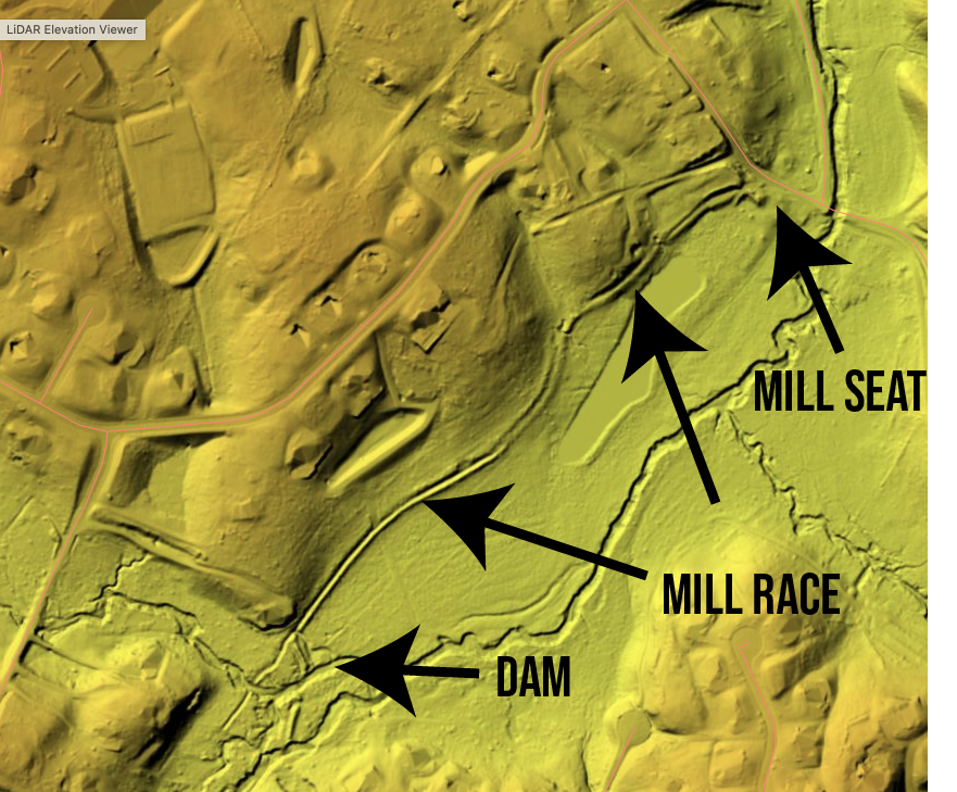
    This makes sense, because that portion of Difficult Run was briefly contested by Tom Rosser’s 5th Virginia Cavalry against a contingent of Federal infantry on the evening of September 1, 1862. While the lion’s share of the Chantilly or Ox Hill fight occurred a mile to the west, this skirmish featured two relatively mobile units occupying straight lines along the creek. 111

    Without an impassable water feature anchoring one end of the line, each opposing unit would have had their flank in the air. No turning maneuver occurred that evening, suggesting that a natural terrain feature, probably the ruins of a millpond, made the landscape unsuitable for tactical advantage. 

    This feature alone was not enough to obscure Fox’s Mill, Fox’s Ford over Difficult Run, or the neighborhood, which was occupied in force by the 6th Michigan Cavalry in June of 1863.112 

    The presence of a cavalry regiment camping at Fox’s Mill feels impossible to anyone who visits the Waples Mill Meadow Park today. There is no signage to interpret the substantial wetlands that sit just west of the road. It is easy to assume that this was the millpond.

    In fact, the submerged or generally moistened mudflats you see today were once a twelve acre field or pasture. This same area was occupied by Federal cavalry in much the same way that it hosted summer revival meetings before the war.113

    We know about the twelve acre pond because of a curious map George Henry Waple III drew in colored pencil in the mid-20th century. The heir of the milling family that purchased the facility from Jane Fox just after the Civil War, the third instantiation of George Henry Waple wanted to preserve place knowledge for the Vale Club.

    (The George Henry Waple III map presented courtesy of Carol, Jonathan, and Sarah Waple. With additional thanks to Chris Barbuschak at the Virginia Room of the Fairfax County Library.)

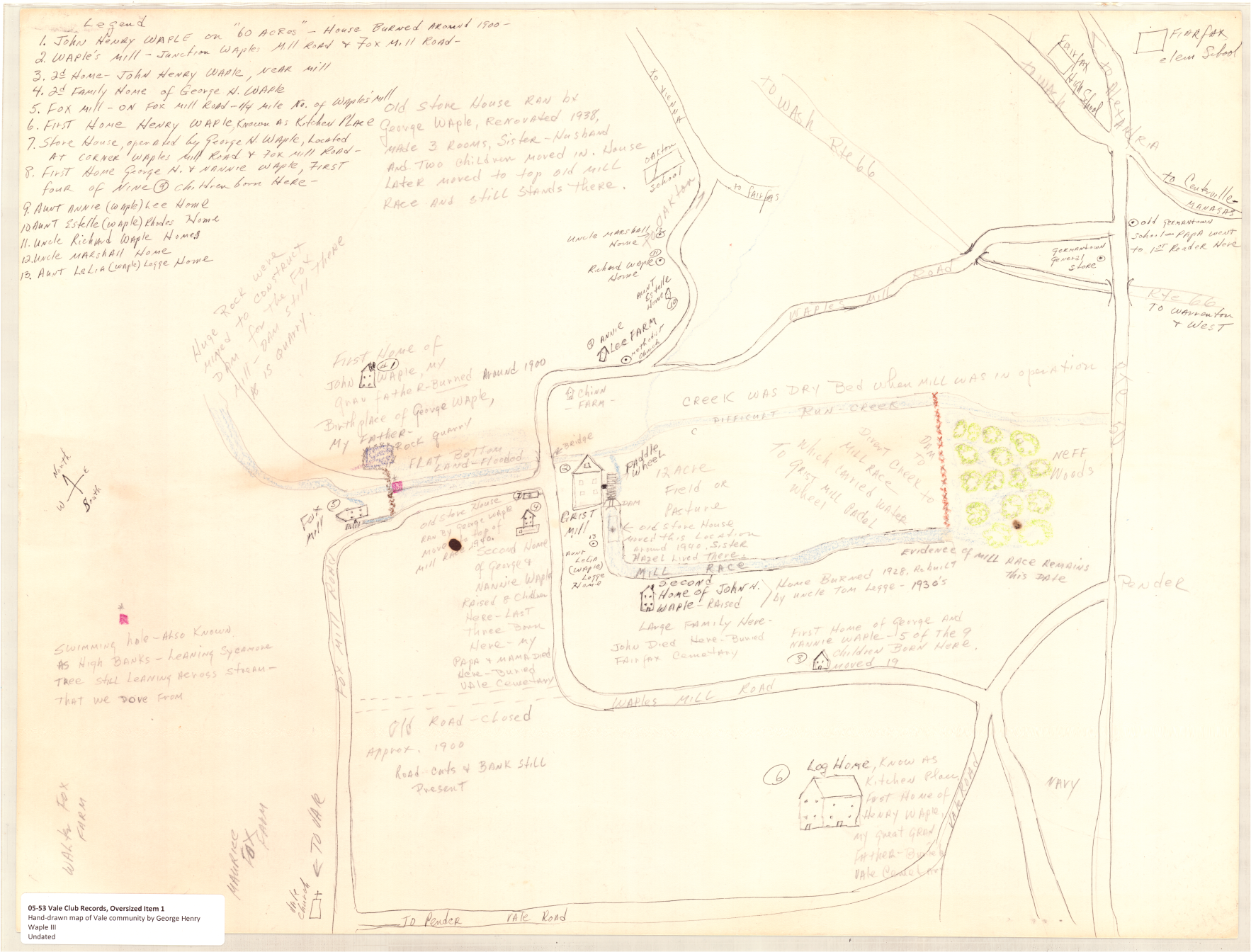
    In doing so, he left a couple of key findings.

    Most tantalizing is a piece of family folklore, which describes a spring house set above the Upper Mill where Mosby was known to hide out for “a few days” when raiding into Fairfax.114

    He indicated that Difficult Run in the area west of today’s Waples Mill Road was “dry bed when mill was in operation.” This speaks to the quality of the dam and millrace that sluiced Difficult Run into the waterwheel at the Upper Mill where gristing and sawing operation took place.

    (Close up of the George Henry Waple III map zoomed in on the area of Fox’s Upper Mill. The location of the spring house is near the structure marked “Second Home of John H. Waple.” The presence of deliberate blue marks in the “Neff Woods” to the right of the red dam seems to indicate substantial water accumulation or marshy conditions in the area between the mill dam and the Little River Turnpike. Courtesy of Carol, Jonathan, and Sarah Waple. With additional thanks to Chris Barbuschak at the Virginia Room of the Fairfax County Library.)

    If this mill infrastructure was robust enough to continue producing marshy conditions upstream even when not in use, we have to wonder about the scene at the Lower Mill less than a half mile downstream. 

    Unlike its companion mill dam, the Lower Mill’s dyke was reinforced with stones quarried on site. The entrenched millrace is still obvious to the naked eye just east of Fox Mill Road, but you’ll have to review LiDAR scans to see the remaining divet on the east side of Difficult Run where heavy stones were pulled from the earth to be built up into a dam. 

    The stone construction was robust and enduring. Writing of his childhood in the late-1920s and early 1930s, George Henry Waple III describes local boys using still more boulders or stones to fill the gap in the old mill dam and create an impressive swimming hole at a spot known as “High Banks.”115

    This site was a fulling mill. At the time of the Civil War, it was owned and operated by Richard Johnson. Described as a “Confederate vidette” when he was arrested after Mosby’s March 1863 raid into Fairfax Court House, Johnson’s most pertinent local claim to fame was that he was the third husband of Jane Fox. 

    This particular marriage produced no children for Jane Fox. However, two boys from her second marriage (Charles Albert and Lt. Frank) and a son-in-law (John Barnes) served with distinction for John Mosby. Additionally, a daughter from her first marriage—Jane Hervey Summers—married John Fox, who was the nephew of Jane’s second husband (Gabriel). John Fox’s mother was the aunt of Albert Wrenn. Better still, John Fox’s daughter, Lucinda, would marry Albert Wrenn, her cousin, the year after Appomattox.

    By the outbreak of the war, John Fox and his brother James owned a good portion of the land surrounding the Lower Mill along Difficult Run. There, they successfully pivoted away from tobacco and into new chattel like timber and sheep. 

    Little is known about the Lower Mill, but its geographic and familial adjacencies suggests that it was built to process wool for John and James Fox. Little did they know at the time that the robustly built mill dam would save them from losing everything during the war. 

    We can comfortably speculate that a substantial marsh essentially hid the lower mill and the valley of Difficult Run running north from it for two very compelling reasons. 

    First, while “Johnson’s Mill” appears on the Federal McDowell Map, the original Fox Mill Road that extended from the dead man’s curve on today’s Fox Mill Road, crossed Difficult Run east of the dam where the road was at least partially dry, and then cut southeasterly to intersect with the road up to Jermantown, did not appear on any Yankee map.

    It does, however, appear in high-fidelity on Confederate maps of the same era. 

    (Johnson’s Mill–otherwise known as Fox’s Lower Mill– depicted at bottom without any apparent road access. The creek above is bisected by Old Bad Road (modern Vale Road) before reaching Hunter’s Mill where the critical interval ends. Courtesy of the LoC.)
    (Granular detail of an 1864 map produced by the Engineering Department of the Confederate ANV. Neither of the Fox Mills are depicted, but the schoolhouse supported by Jane Fox is shown with the initials “SH” at the modern intersection of Waples Mill and Oakton Roads east of Difficult Run where the Fox Mill was once located. Branching off from the main road at this same site is the first version of modern Fox Mill Road, which historical documents suggest charted up the eastern side of Difficult Run before crossing the creek at or behind the mill dam for the Lower Mill. The fact that this critical roadway was not included on Federal maps suggests that it was obscured. Still, its presence was obviously known to Confederates who enjoyed superior place knowledge. Courtesy of the LoC.)

    The existence of this road is somewhat controversial, but a road petition from 1867 makes its position quite clear:

    “Respectfully report that the present county road runs not he East Side of Fox’s Mill dam and that in consequence of the narrowness of the road between the mill dam and the high land opposite together with the over flow of the dam and the low land upon which the repent road is located, it is almost impracticable to keep this road in repair, and they think it should be abandoned.”116

    The petition continues to specify an alternate route west of the dam and across the land of Henry Waple, which clarifies that it is referencing the lower mill. Anyone traveling south on Fox Mill Road can see obvious signs of the original road bed. 

    (The depression pictured here slopes downwards from the existing roadway on a slope and direction consistent with the pre-1867/wartime configuration of the route connecting today’s Vale Road with Johnson’s or Fox’s Lower Mill and the road to Jermantown beyond.)
    (Overhead location of the previous photo’s perspective to enhance context.)

    Road knowledge as portrayed on Civil War-era maps indicates that this section marking the southern limit of the critical interval of Mosby’s operations area was effectively hidden.

    Better still, post-war road petitions suggest that Old Bad Road eeked closer to Difficult Run at the John Fox property during the war than it does today. Modern lidar scans reveal the remaining trace of the original Vale Road, which was modified in 1872 to accommodate the two current ninety degree turns the road takes between Fox Den Lane and Rifle Ridge Road. 

    During the war, Old Bad Road extended eastwards through the John Fox property on an 89 rod path across the current site of the cul-de-sac at the end of Young Drive. It eventually darted north for 122 rods and joined the current Vale Road bed east of Berryland Drive. Today’s property lines reflect the original course.117

    (Modern property lines still conform to the wartime dimensions of Old Bad Road. Pictured here with chunky blue arrows is the roadway as it existed from the 1840s until 1872. The slender black arrows point toward modern Vale Road, the successor route that takes a higher route less vulnerable to mud. LiDAR screen capture courtesy of the Fairfax County GIS and Mapping Services Division.)
    (Buried in the Fairfax County Road Petitions collection at the Historic Records Center in the Fairfax Court House is this map, which accompanies a June 1872 order for the “Old County Road” otherwise known in the Civil War as “Old Bad Road” to conform to its current configuration with two odd ninety degree turns. Record of Roads 1860-1904. Page 89. Courtesy of the Honorable Christopher J. Falcon, Clerk of Court.)
    (Once you remove the property lines, the LiDAR scan’s superior ability to discern landscape leaves a stunning impression. The abandoned Old Bad Road rut is still patently obvious as it darts off of modern Vale Road at bottom left, tracks to bottom center and then shoots to upper right. LiDAR screen capture courtesy of the Fairfax County GIS and Mapping Services Division)

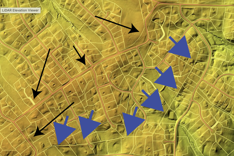
    The modification that created the cumbersome turns known to all who take Vale Road today was executed ostensibly to shuttle traffic onto higher topography. The earlier iteration carried wagons over and through high tributaries, which would have offered muddy slurry for travelers to contend with. It’s possible that this particular elbow of Old Bad Road was one of the most offensive stretches when road quality was considered.

    This low course had an advantage, however, in that if offered closer proximity to Difficult Run. Today’s LiDAR imagery reveals long out-of-use paths that once funneled traffic downhill from Old Bad Road towards Difficult Run.

    (At the angle where Old Bad Road turned northeast, a separate road trace cuts southwards towards Difficult Run. At several other junctures to the west, other apparent lanes branch off from the road in either direction. LiDAR screen capture courtesy of the Fairfax County GIS and Mapping Services Division)
    (Developed heavily and dammed in the last fifty years, much of the topography south of Old Bad Road has been altered significantly since the Civil War. Nonetheless, literal bridle paths tracing historic creek branches in parallel and perpendicular configurations offer suggestions at patterned human interaction that has shaped route-making in the critical interval of Difficult Run. LiDAR screen capture courtesy of the Fairfax County GIS and Mapping Services Division)
    (The Fairfax County Park Authority maintains the Gerry Connolly Cross Country Trail–a real treat for anyone hoping to experience the Upper Difficult Run Basin in a more rugged context than that of a subdivision. Unfortunately, it can be a challenge to parse out what paths were developed recently, coopted by the county, or existed previously. Some phantom traces in this LiDAR scan are tantalizing in the ways they proceed with temporary depth and dead end suddenly. There are many routes here expressing many generations of use across this fertile valley with its many convenient fording places. LiDAR screen capture courtesy of the Fairfax County GIS and Mapping Services Division)
    (Modern image of the creek bed of Difficult Run just north of Miller Road. Bank depth was approximately four feet and bank to bank width was twenty nine feet. Excellent ability to cross unimpeded.)

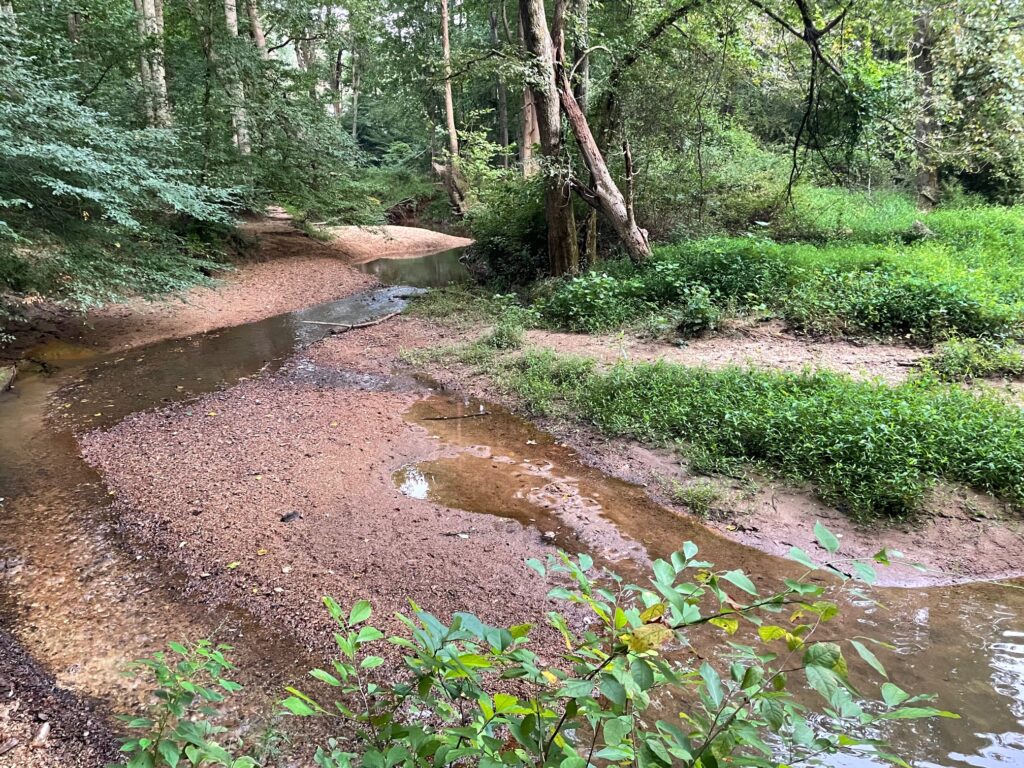
    Just south of this forgotten roadway is a place where the 1912 topographic map records a curiously complete roadway bridging Difficult Run from Vale into Oakton itself. It occupies a space in the vicinity of modern Miller Road. This mystery roadway could have been a summer route over Difficult Run. Today, a deprecated copy of the county property and roadway map used as the base layer for the LiDAR surveys records a phantom extension of Miller Road that continues past its present terminus on Miller Heights Road to a point mid-stream on Difficult Run.

    (Pictured at center, Miller Road is one of only two roadways that are depicted on the county road map extending mid-course over Difficult Run without being in modern use as crossing points. The other is Hunter’s Valley Road. Located just north of Vale Road, the defunct roadbed is quite obvious on the LiDAR scans. This suggests that at one point, Miller Road was considered as a formal roadway over Difficult Run. LiDAR screen capture courtesy of the Fairfax County GIS and Mapping Services Division)
    (R.B. Marshall’s 1912 topographic map of the Fairfax Quadrangle depicts a roadway near the location where Miller Road extends to midstream on Difficult Run today and in the same basic area that I speculate John Mosby and his men successfully used to cross Federal lines.)

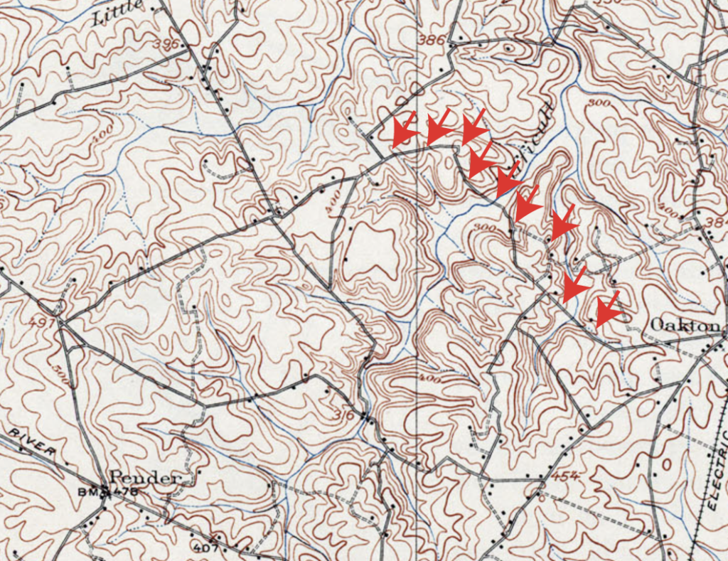
    Another dimension of the particular place puzzle connecting Mosby with the John Fox property and Old Bad Road is the intriguing case of John and James Fox and their livestock. 

    Accounts of Fairfax County from the war years describe the landscape as if a pack of locusts had devoured it. Buildings, fences, trees, fruit, grain, and animals owned by locals who supported both sides were devoured wholesale by armies that shared significant logistical challenges and caloric needs. 

    In 1860, James Fox owned twenty five head of cattle and seventy five sheep and hogs. His brother John had twenty eight head of cattle and fifty eight sheep or hogs. 

    Over the ensuing five years, both armies came within a stone’s throw of their farms along Difficult Run. A Federal cavalry regiment camped nearly on top of them for almost a month. Hungry, desperate men with diminishing compunctions about good conduct and honor ran roughshod over the area around them.

    And yet, in 1866 James Fox—who owned the more exposed of the two properties—still retained seventeen head of cattle, seventeen hogs, and ten sheep. His brother John—whose pasturage was hidden well behind the veil of the Lower Mill Dam within the deepest section of the Upper Difficult Run valley—still had fifteen cattle, five hogs, and twenty sheep.118 

    On either side of these men at Jermantown and near Frying Pan, each army had feasted rapaciously on the assets held by locals, leaving no stone unturned until the rightful owners of that land were destitute.119 The Fox brothers who enjoyed access to the land behind a stone-built mill dam and the protection of its marshy pond, to say nothing of their familial relationships with prominent Rangers, were largely unscathed.

    To Sum It All Up

    John Mosby the man and “Mosby” the abstract phantom had the potential to strike almost anywhere within Northern Virginia. A closer analysis of the Gray Ghost’s associates and confirmed actions reveal patterns to the way he haunted the landscape. 

    The critical interval of Difficult Run—4.4 miles of hidden creek bed between Fox’s Lower Mill and Hunter’s Mill—served as an access point and a labyrinthine fortress where a guerrilla chieftain hid successfully thanks to the good graces of loyal families and opportune terrain. Mosby was a presence here from January 1863 to March of 1865, but for nine months in 1863 this area was essentially a forward operating base for the Gray Ghost.
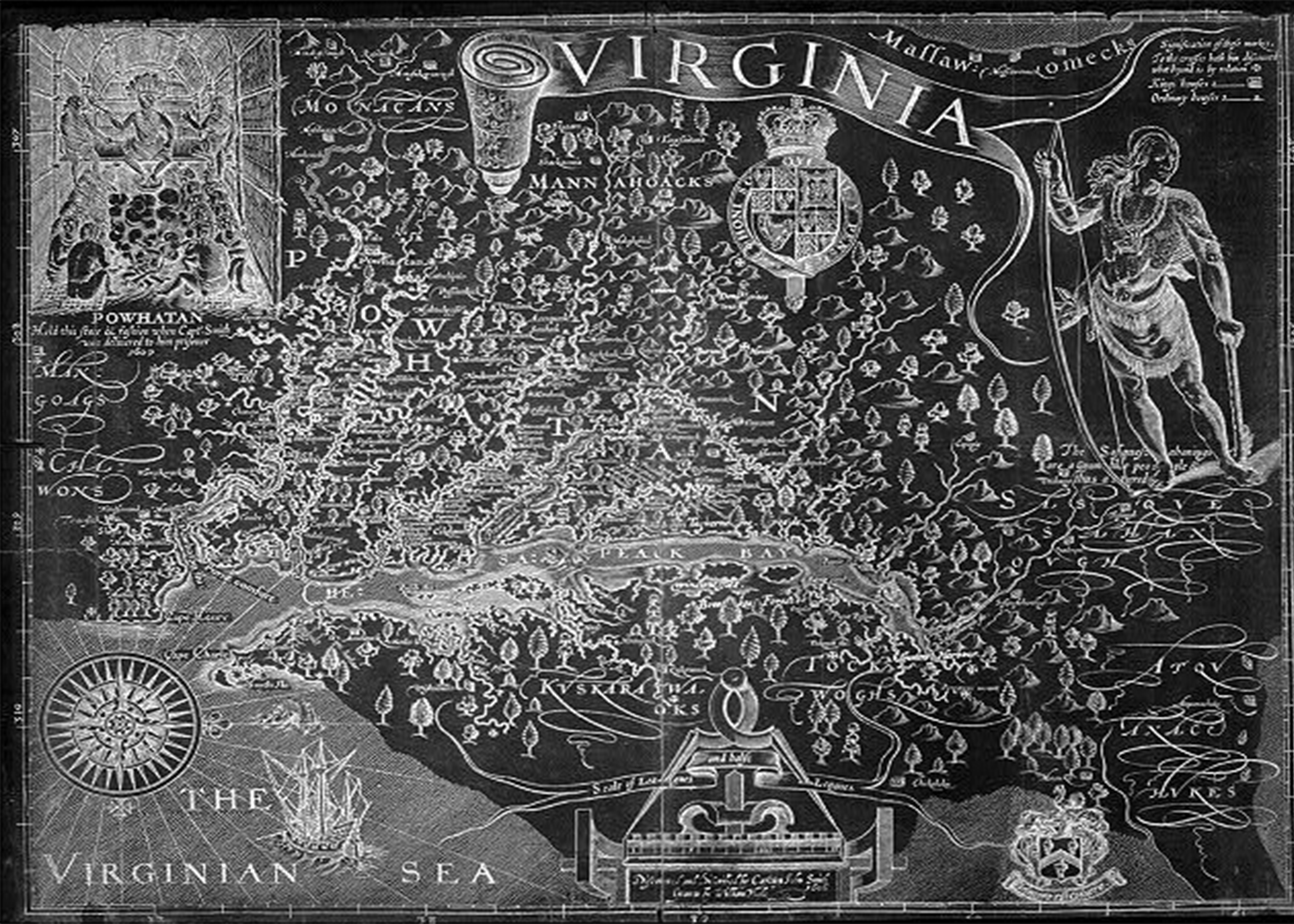
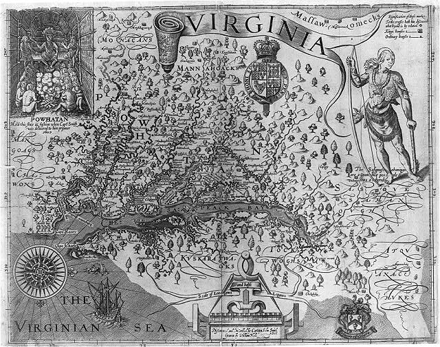
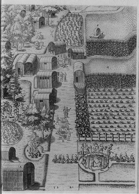
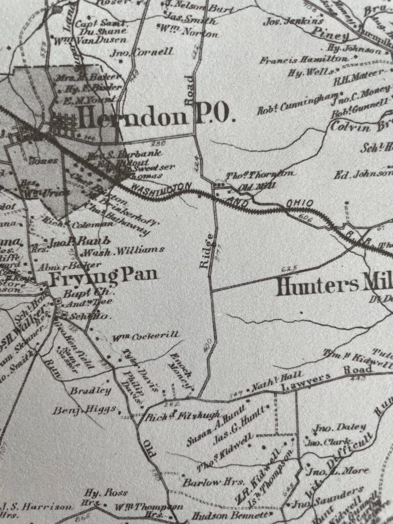
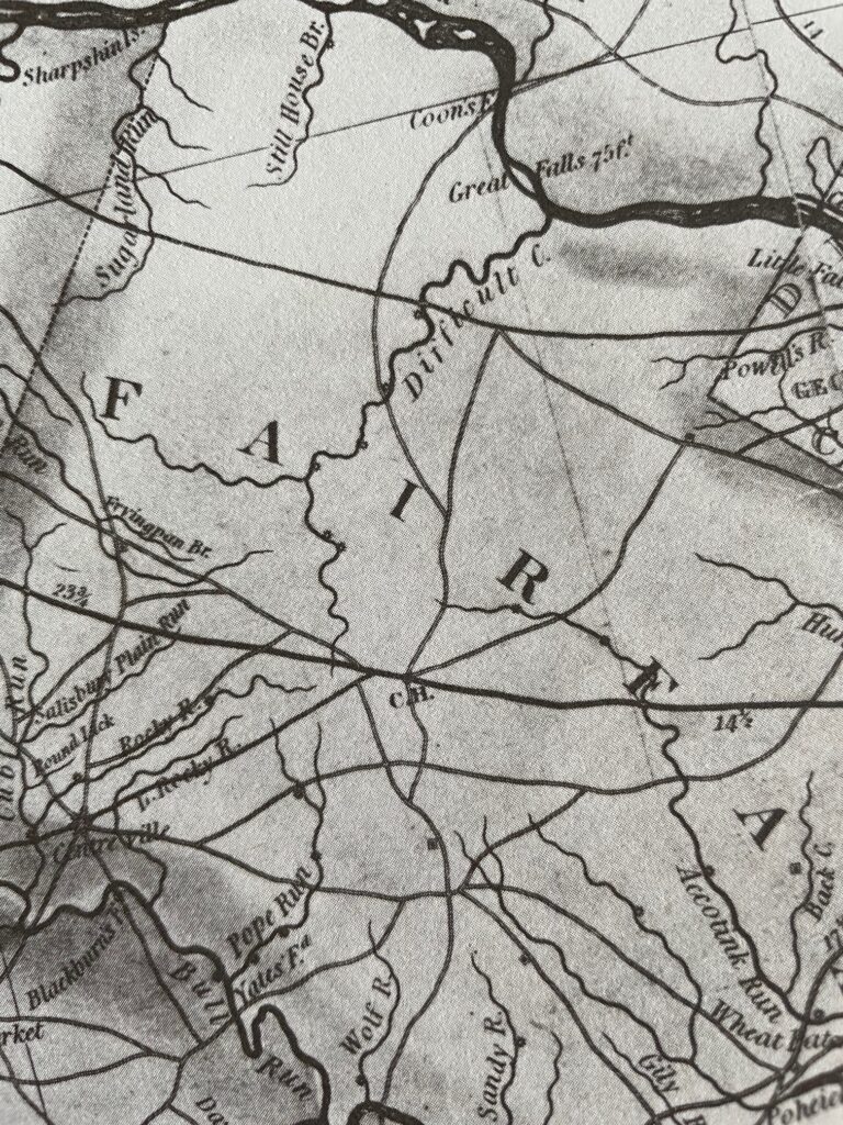
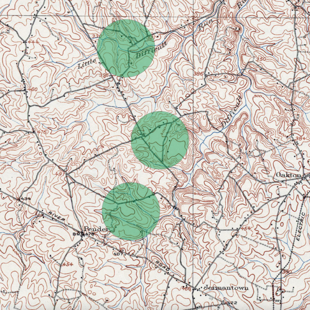
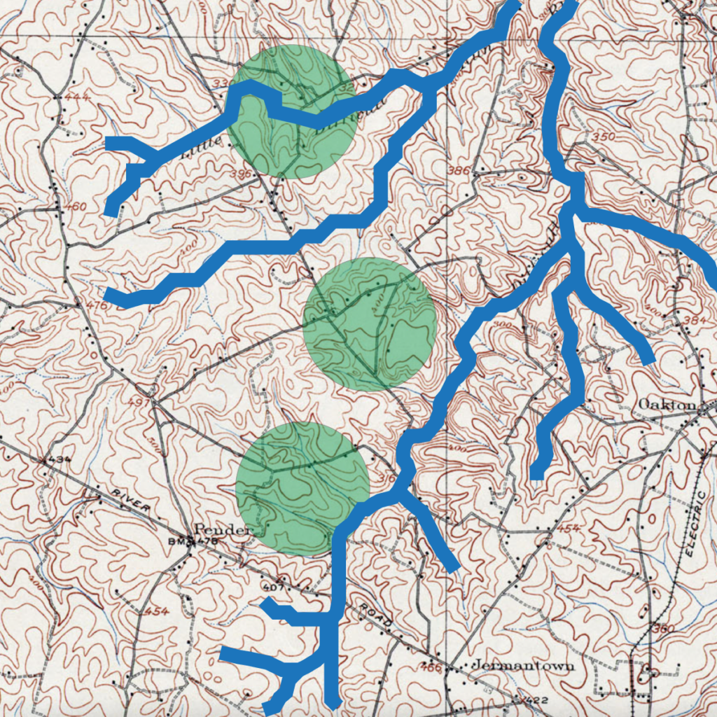
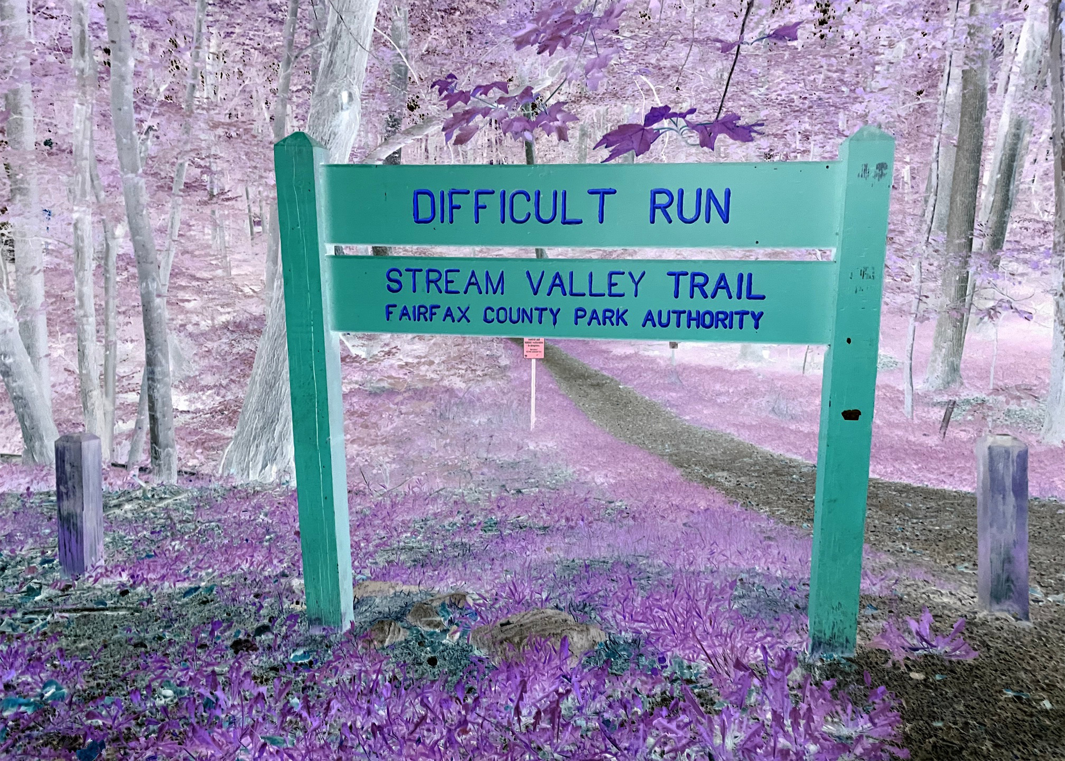
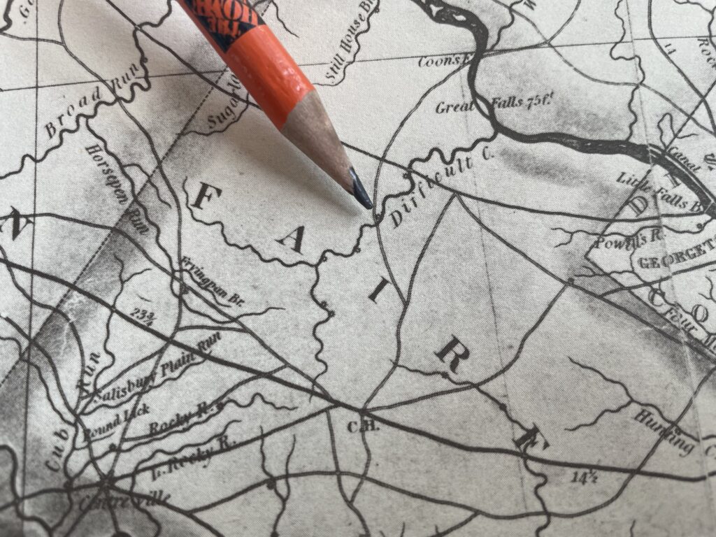
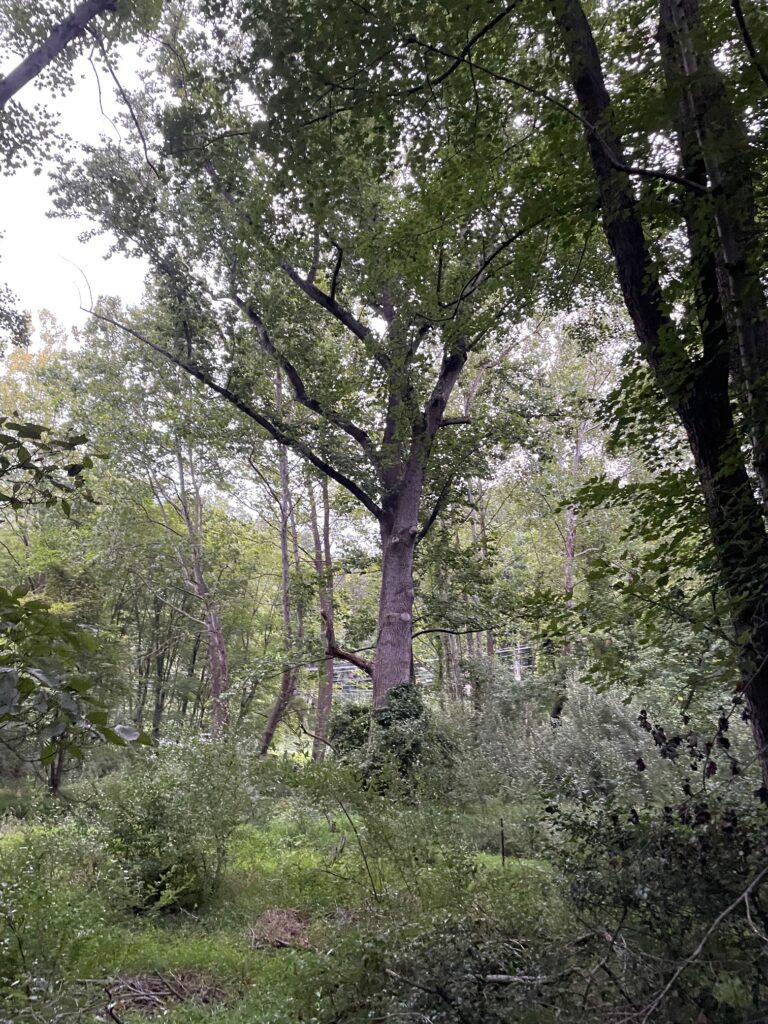
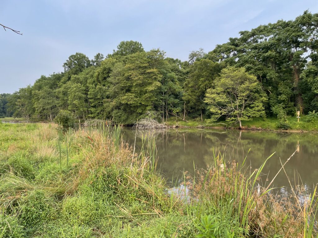
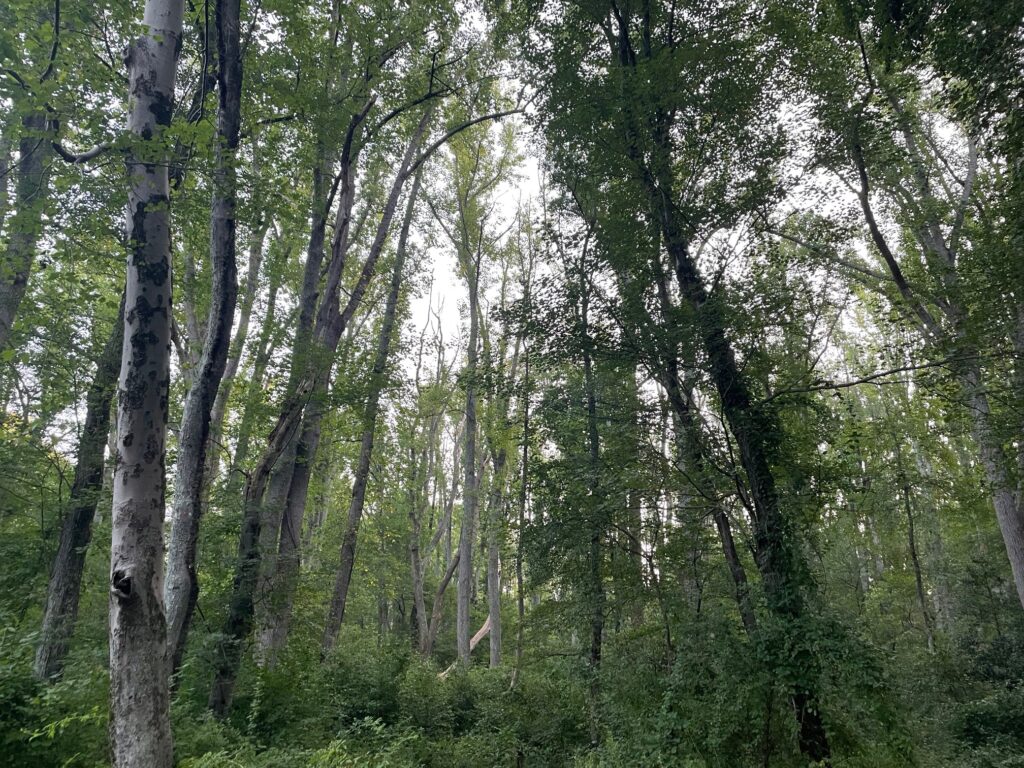
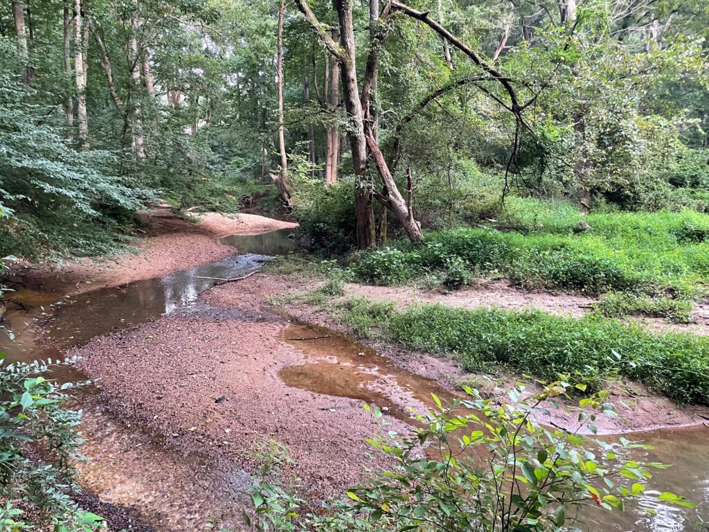
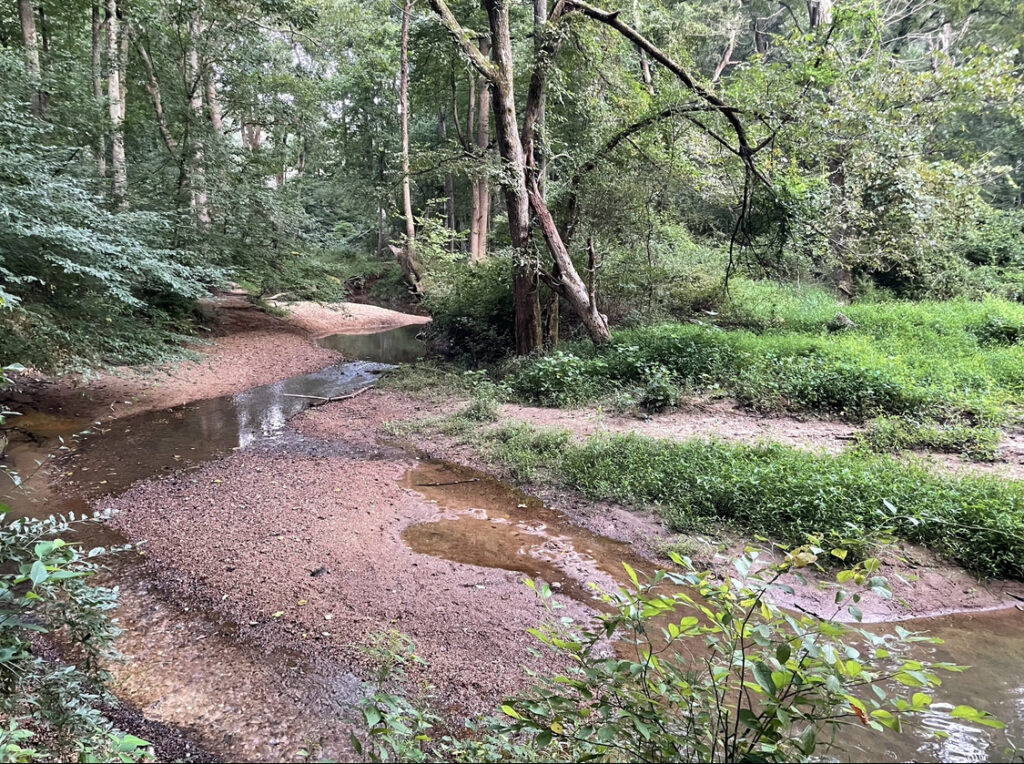
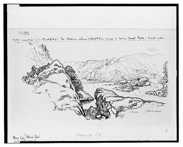
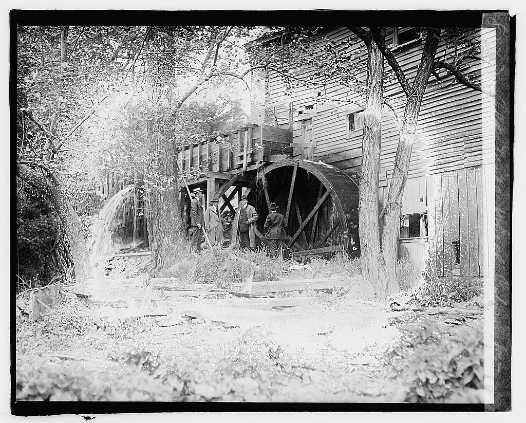
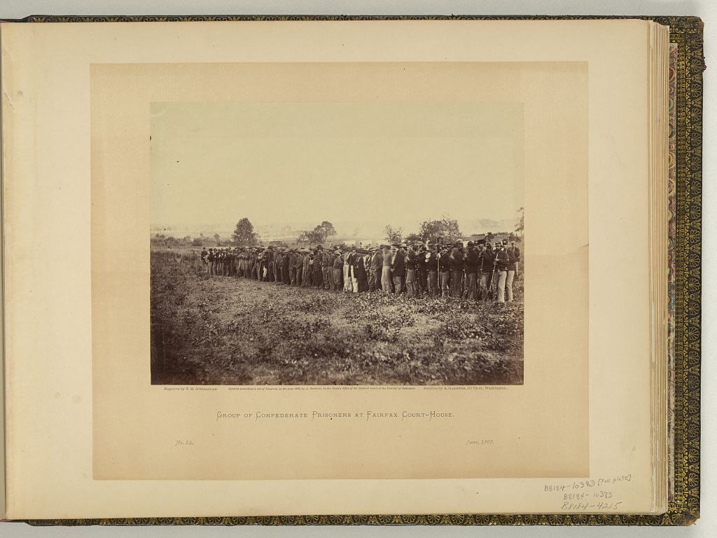
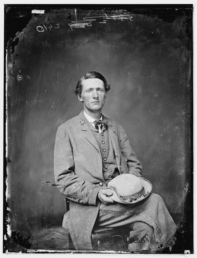
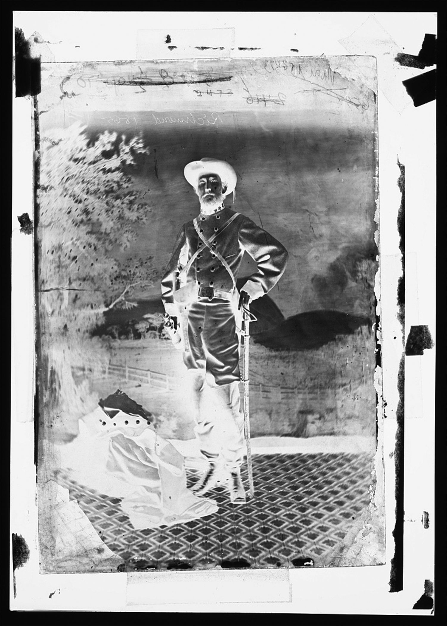
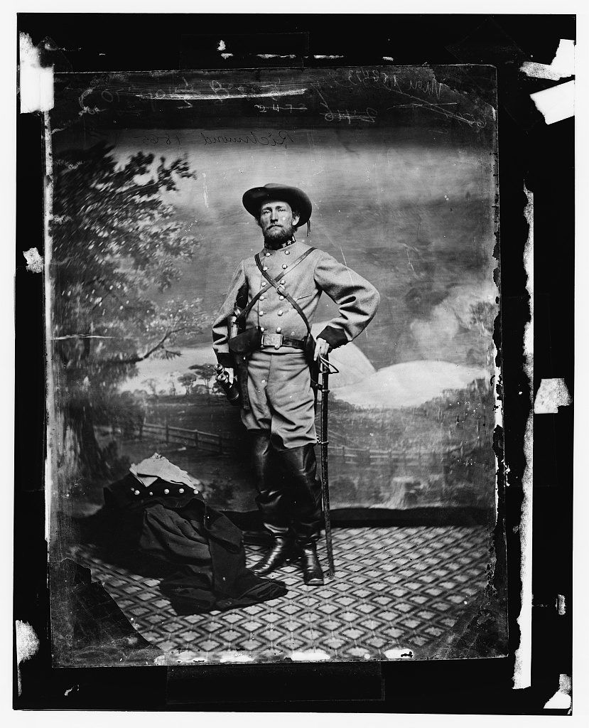
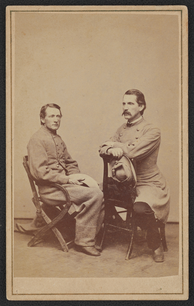
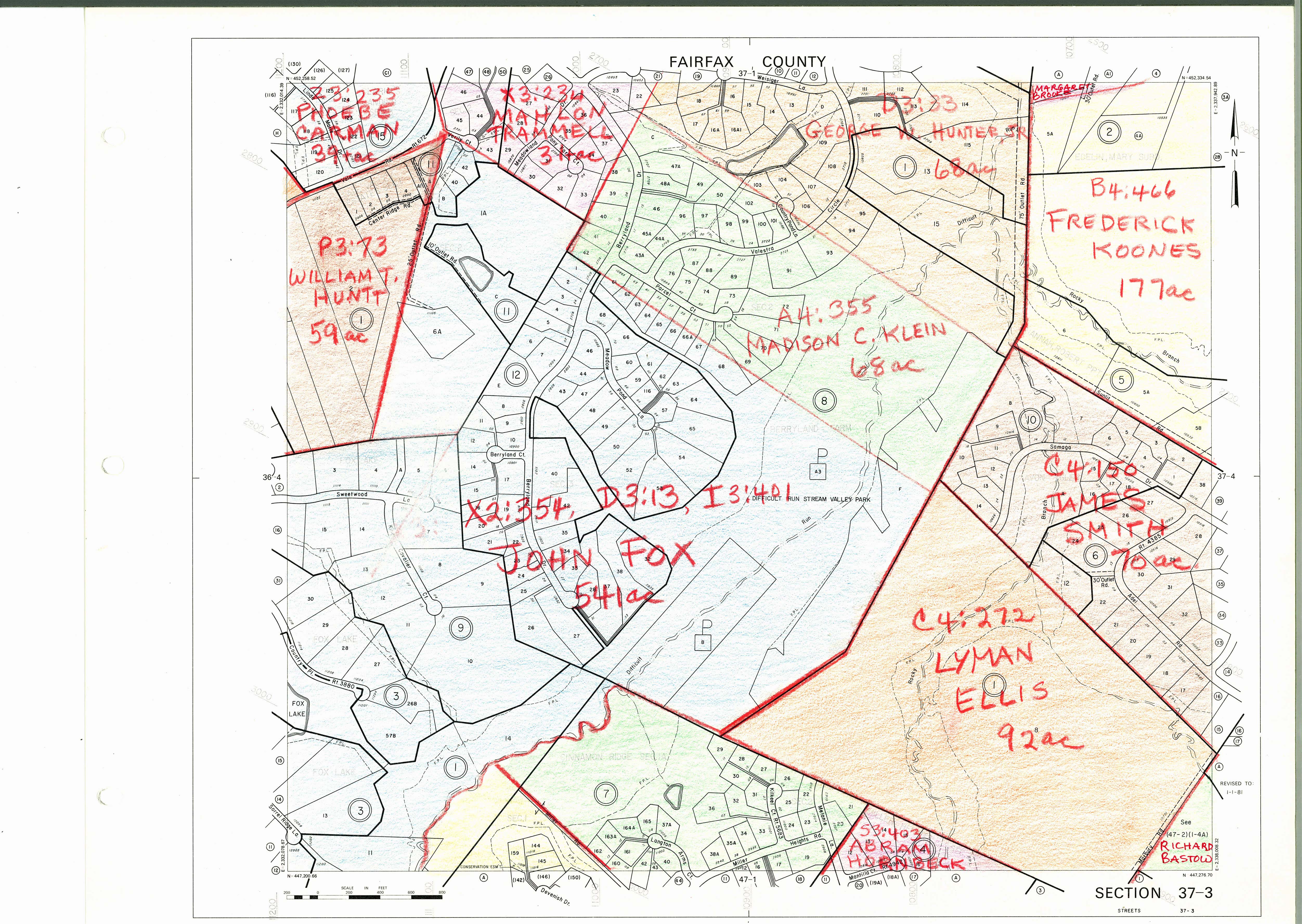
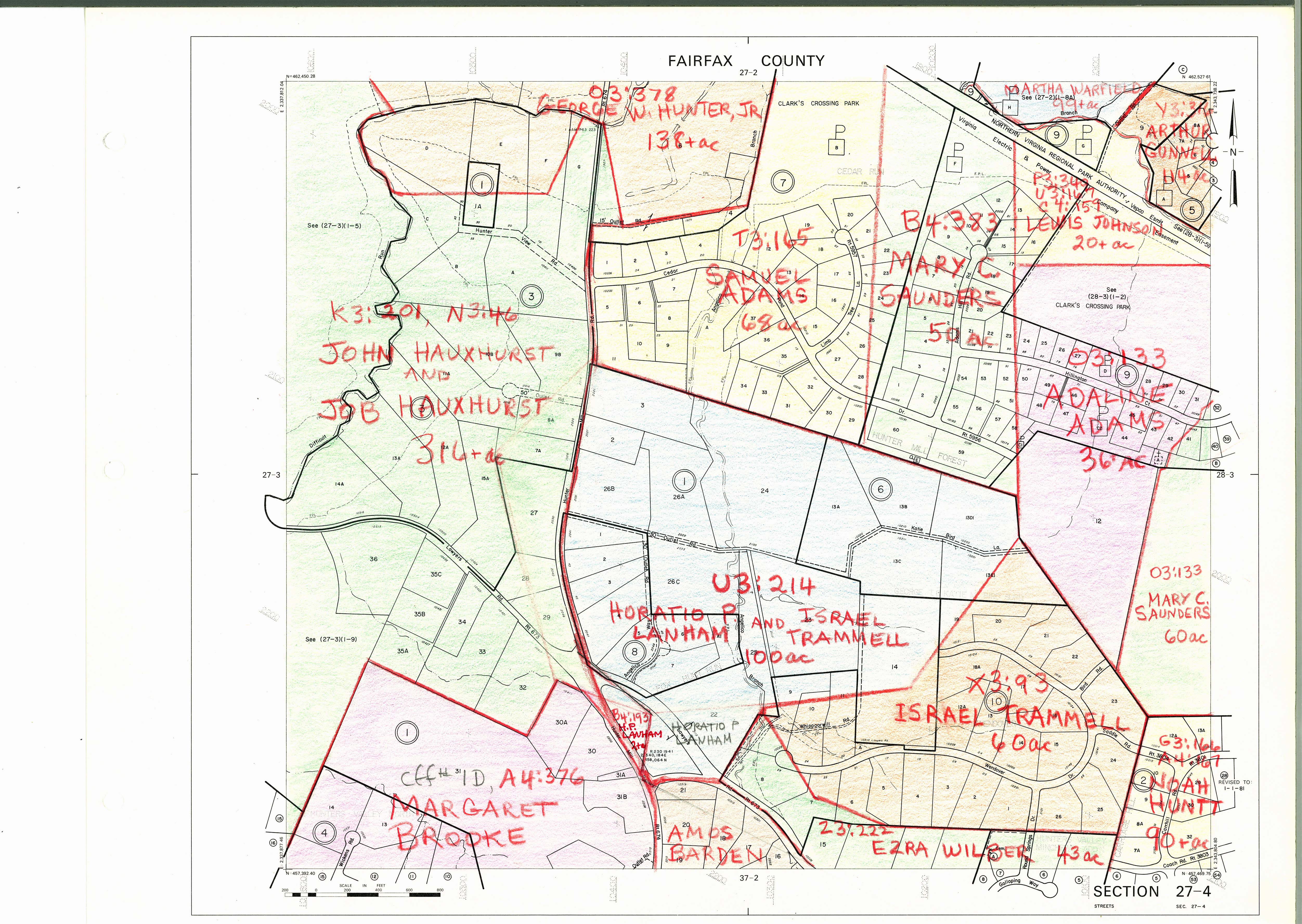
    Sources
    1. Keen, Hugh C. And Horace Mewborn. 43rd Battalion Virginia Cavalry Mosby’s Command. Lynchburg: H.E. Howard, Inc, 1993. p. 287.
    2. O’Neill, Robert F. Chasing Jeb Stuart and John Mosby. Jefferson: McFarland & Company Inc, 2012. p. 4. 
    3.  Catlin, Martha Claire. The Quaker Scout: Testimony of a Civil War Non-Combatant of the Woodlawn Antislavery Colony. Columbia: Quaker Heron Press, 2022. p. 202.
    4.  Keen, Hugh C. And Horace Mewborn. 43rd Battalion Virginia Cavalry Mosby’s Command. Lynchburg: H.E. Howard, Inc, 1993. p. 8.
    5.  “Mosby’s Rangers: Lessons in Intelligence and Special Operations.” Center for the Study of Intelligence, Central Intelligence Agency, 2015. https://cia.gov/readingroom/docs/MOSBYS%20RANGERS%20%20LESSONS%20I%5B14652261%5D.pdf p. 57.
    6.  Mosby, John Singleton. Reminiscences. New York: Dodd, Mead & Company, 1887. p. 19.
    7.  Fairfax County Road Petitions. Box 1: 1844-1908. Historic Records Center. Fairfax County Courthouse. Fox, Jane RP-006, May 1845. 
    8. McDowell, Irwin. Military Reconnaissance of Virginia. 1/24000. 1863. “Library of Congress: Civil War Maps.” < https://www.loc.gov/resource/g3880.cw0481400/?r=0.679,0.499,0.114,0.067,0>
    9.  Mauro, Charles V. The Civil War in Fairfax County. Charleston: The History Press, 2006. p. 99.
    10.  Jones, Virgil Carrington. Ranger Mosby. Chapel Hill, University of North Carolina Press, 1944. p. 90.
    11.  O’Neill, Robert F. Chasing Jeb Stuart and John Mosby. Jefferson: McFarland & Company Inc, 2012. p. 59. 
    12.  Munson, John W. Reminiscences of a Mosby Guerrilla. New York: Moffat, Yard and Company, 1906. p. 42.
    13.  “Benjamin Thornton, Joseph Thornton, & Samuel Stead: English Rascals, Vienna-Area Landowners.” Vienna Virginia History. https://viennavahistory.com/2022/09/05/benjamin-thornton-joseph-thornton-samuel-stead-english-rascals-vienna-area-landowners/ The Thorntons made the area north of today’s Dulles Tollroad into a massively productive timber farm exporting Virginia lumber to England.
    14.  Keen, Hugh C. And Horace Mewborn. 43rd Battalion Virginia Cavalry Mosby’s Command. Lynchburg: H.E. Howard, Inc, 1993. p. 377.
    15.  Chancery Records Index. Virginia Memory—Library of Virginia. <https://lva.virginia.gov/chancery/> When Mahlon Trammell died in September 1866, Margaret Trammell is remembered as Margaret Underwood in the Chancery case. https://www.lva.virginia.gov/chancery/full_case_detail.asp?CFN=059-1878-014#img
    16.  Mitchell, Beth. 1860 Fairfax County Maps. 1977. “Fairfax County History Commission. “ < https://fairfaxcounty.gov/history-commission/1860-Fairfax-county-maps > Mahlon Trammell’s property immediately abutting John Fox along Old Bad Road is particularly noteworthy. See panel 37-3. https://www.fairfaxcounty.gov/history-commission/sites/history-commission/files/Assets/documents/1860CountyMap/37-3.jpg
    17.  O’Neill, Robert F. Chasing Jeb Stuart and John Mosby. Jefferson: McFarland & Company Inc, 2012. p. 152. 
    18.  ibid 207.
    19.  Hakenson, Donald C. And Charles V. Mauro. A Tour Guide and History of Col. John S. Mosby’s Combat Operations in Fairfax County. Fairfax: HMS Productions, 2013. p. 25.
    20.  Keen, Hugh C. And Horace Mewborn. 43rd Battalion Virginia Cavalry Mosby’s Command. Lynchburg: H.E. Howard, Inc, 1993. p. 27.
    21.  O’Neill, Robert F. Chasing Jeb Stuart and John Mosby. Jefferson: McFarland & Company Inc, 2012. p. 133. 
    22.  ibid 100.
    23.  Keen, Hugh C. And Horace Mewborn. 43rd Battalion Virginia Cavalry Mosby’s Command. Lynchburg: H.E. Howard, Inc, 1993. p. 25.
    24.  Jones, Virgil Carrington. Ranger Mosby. Chapel Hill, University of North Carolina Press, 1944. p. 214.
    25.  Russell, Charles Wells, ed. The Memoirs of Colonel John S. Mosby. Boston: Little, Brown, and Company, 1917. https://docsouth.unc.edu/fpn/mosby/mosby.html p. 168. 
    26.  Jones, Virgil Carrington. Ranger Mosby. Chapel Hill, University of North Carolina Press, 1944. p. 84.
    27. “Fairfax Fast Fact.” The Fare Facs Gazette 16, no. 4 (Fall 2019): pg. 2. https://www.historicfairfax.org/wp-content/uploads/2019/11/HFCI1604a-1.pdf
    28.  The War of the Rebellion: Official Records of the Civil War. Ohio State University eHistory.War of the Rebellion: Serial 018 Page 0786, Operations in N. VA., W. VA., AND MD. Chapter XXIV. https://ehistory.osu.edu/books/official-records/018-0786 
    29.  Russell, Charles Wells, ed. The Memoirs of Colonel John S. Mosby. Boston: Little, Brown, and Company, 1917. https://docsouth.unc.edu/fpn/mosby/mosby.html p. 168. 
    30.  O’Neill, Robert F. Chasing Jeb Stuart and John Mosby. Jefferson: McFarland & Company Inc, 2012. p. 102. 
    31.  Marlene Lenthang. “Once named after Confederate soldier, Virginia middle school renamed after NASA’s Katherine Johnson.” ABC News. June 5, 2021. https://abcnews.go.com/US/named-confederate-soldier-virgina-middle-school-renamed-nasas/story?id=78102806 Known as Sidney Lanier Middle School for much of my childhood, the institution was only recently renamed in a worthy slight to the Confederacy’s poet laureate. 
    32.  Russell, Charles Wells, ed. The Memoirs of Colonel John S. Mosby. Boston: Little, Brown, and Company, 1917. https://docsouth.unc.edu/fpn/mosby/mosby.html p. 168. 
    33.  Keen, Hugh C. And Horace Mewborn. 43rd Battalion Virginia Cavalry Mosby’s Command. Lynchburg: H.E. Howard, Inc, 1993. p. 39.
    34.  Lundegard, Marjorie. “Mills and Mill Sites in Fairfax County, Virginia and Washington, DC.” Society for the Preservation of Old Mills Mid-Atlantic Chapter (August 10, 2009). https://spoommidatlantic.org/uploads/editor/files/Mid-Atlantic_Mills/Fairfax_County%2526_DC_Mills-Book-5-8-2009.pdf p 11-12.
    35.  Alexandria Gazette: 1834-1974. Chronicling America: Historic American Newspapers. Library of Congress. <https://chroniclingamerica.loc.gov> September, 4, 1844. https://chroniclingamerica.loc.gov/lccn/sn85025007/1844-09-04/ed-1/seq-3/#date1=1777&sort=date&rows=20&words=Fox+Mills&searchType=basic&sequence=0&index=1&state=District+of+Columbia&date2=1963&proxtext=”fox’s+mills”&y=0&x=0&dateFilterType=yearRange&page=1
     36. Joe Reeder Interview. Conducted with Jason Hampel at Squirrel Hill sometime in 2013. Video provided by Jason Hampel. 
    37.  Fairfax County Historic Deed Book: 1742-1866. Historic Records Center. Fairfax County Courthouse. <https://fairfaxcounty.gov/circuit/historic-records-center/finding-aids/deeds> W3, pg. 406. 
    38.  Joy S. Starr Collection on Vale History. Collection 06-18. Virginia Room. Fairfax County Library. “Vale History: From Money’s Corner through Difficult: A Fox Mill Communities Neighborhood History.” p. 34-41.
    39.  Keen, Hugh C. And Horace Mewborn. 43rd Battalion Virginia Cavalry Mosby’s Command. Lynchburg: H.E. Howard, Inc, 1993. p. 294.
    40.  Netherton, Nan, Donald Sweig, Janice Artemel, Patricia Hicks, and Patrick Reed. Fairfax County, Virginia: A History. Fairfax: Fairfax County Board of Supervisors, 1978. p. 255. 
    41.  Alexandria Gazette: 1834-1974. Chronicling America: Historic American Newspapers. Library of Congress. <https://chroniclingamerica.loc.gov> March 18, 1863. https://chroniclingamerica.loc.gov/lccn/sn85025007/1863-03-18/ed-1/seq-1/#date1=1770&index=0&rows=20&words=Fox+Francis&searchType=basic&sequence=0&state=District+of+Columbia&date2=1900&proxtext=”francis+fox”&y=7&x=17&dateFilterType=yearRange&page=1
    42.  Keen, Hugh C. And Horace Mewborn. 43rd Battalion Virginia Cavalry Mosby’s Command. Lynchburg: H.E. Howard, Inc, 1993. The roster is the best source for collated enlistment data. 
    43.  Joy S. Starr Collection on Vale History. Collection 06-18. Virginia Room. Fairfax County Library. “Vale History: From Money’s Corner through Difficult: A Fox Mill Communities Neighborhood History.” p. 36. This curious account comes from Owen Welby Clarke, Thomas I. Clarke’s grandson. James N. Gunnell and John Saunders appear on the rolls. (Although, John Saunders is listed as “Sanders,” a phonetic spelling of his name.) No Thomas I. Clarke presents itself, although other Clarkes from Fairfax County do. 
    44.  Keen, Hugh C. And Horace Mewborn. 43rd Battalion Virginia Cavalry Mosby’s Command. Lynchburg: H.E. Howard, Inc, 1993. p. 326
    45.  ibid p. 375. 
    46.  Mosby, John Singleton. Reminiscences. New York: Dodd, Mead & Company, 1887. p. 77. 
    47.  O’Neill, Robert F. Chasing Jeb Stuart and John Mosby. Jefferson: McFarland & Company Inc, 2012. p. 152.
    48.  O’Neill, Robert F. Chasing Jeb Stuart and John Mosby. Jefferson: McFarland & Company Inc, 2012. p. 163.
    49.  “War News.” Alexandria Gazette. April 14, 1863. https://newspapers.com/image/347355867/ 
    50.  ibid 189 and 206-207
    51.  Joy S. Starr Collection on Vale History. Collection 06-18. Virginia Room. Fairfax County Library. “Vale History: From Money’s Corner through Difficult: A Fox Mill Communities Neighborhood History.” p. 12.
    52.  The War of the Rebellion: Official Records of the Civil War. Ohio State University eHistory. Serial 044, Page 0989, Chapter XXXIX. Mosby’s Operations, ETC. https://ehistory.osu.edu/books/official-records/044/0989
    53. The War of the Rebellion: Official Records of the Civil War. Serial 048, Page 0068, OPERATIONS IN N.C., VA., W. VA., MD., AND PA. Chapter XLI. https://ehistory.osu.edu/books/official-records/048/0068
    54. The War of the Rebellion: Official Records of the Civil War. Serial 045, Page 0151, Chapter XXXIX. Correspondence, Etc., – Union. https://ehistory.osu.edu/books/official-records/045/0151
    55.  The War of the Rebellion: Official Records of the Civil War. Serial 045, Page 0150, N.C., VA., W. VA., MD., PA., ETC. Chapter XXXIX. https://ehistory.osu.edu/books/official-records/045/0150
    56.  Evans, D’anne A. The Story of Oakton, Virginia: 1758-1990. Oakton: The Optimist Club of Oakton, 1991. P. 42.
    57.  Keen, Hugh C. And Horace Mewborn. 43rd Battalion Virginia Cavalry Mosby’s Command. Lynchburg: H.E. Howard, Inc, 1993. p. 377. 
    58.  ibid 274. 
    59.  The War of the Rebellion: Official Records of the Civil War. Serial 048, Page 0494 OPERATIONS IN N.C., VA., W.VA., MD., AND PA. Chapter XLI. https://ehistory.osu.edu/books/official-records/048/0494
    60.  Keen, Hugh C. And Horace Mewborn. 43rd Battalion Virginia Cavalry Mosby’s Command. Lynchburg: H.E. Howard, Inc, 1993. p. 374. 
    61. ibid 131.
    62. ibid 169.
    63.  ibid p 246, 207, 167
    64.  ibid p. 92.
    65.  The War of the Rebellion: Official Records of the Civil War. Serial 090, Page 0616 OPERATIONS IN N.C., VA., W. VA., MD., AND PA. Chapter LV. https://ehistory.osu.edu/books/official-records/090/0616
    66.  Keen, Hugh C. And Horace Mewborn. 43rd Battalion Virginia Cavalry Mosby’s Command. Lynchburg: H.E. Howard, Inc, 1993. p. 244.
    67.  Evans, D’anne A. The Story of Oakton, Virginia: 1758-1990. Oakton: The Optimist Club of Oakton, 1991. P. 44.
    68.  Russell, Charles Wells, ed. The Memoirs of Colonel John S. Mosby. Boston: Little, Brown, and Company, 1917. https://docsouth.unc.edu/fpn/mosby/mosby.html p. 4.
    69.  ibid 109-119
    70.  The War of the Rebellion: Official Records of the Civil War. Serial 045, Page 0150, N.C., VA., W. VA., MD., PA., ETC. Chapter XXXIX. https://ehistory.osu.edu/books/official-records/045/0150
    71.  Evans, D’anne A. The Story of Oakton, Virginia: 1758-1990. Oakton: The Optimist Club of Oakton, 1991. P. 61.
    72.  Peterson, Arthur G. “The Alexandria Market Prior to the Civil War.” The William and Mary Quarterly 12, no. 2 (1932): 102-14. https://doi.org/10.2307/1921462 
    73.  Netherton, Nan, Donald Sweig, Janice Artemel, Patricia Hicks, and Patrick Reed. Fairfax County, Virginia: A History. Fairfax: Fairfax County Board of Supervisors, 1978. P. 46.
    74.  Alexandria Gazette: 1834-1974. Chronicling America: Historic American Newspapers. Library of Congress. <https://chroniclingamerica.loc.gov> September 04, 1844, Image 3. 
    75.  Alexandria Herald: 1813-1825. Virginia Chronicle. Library of Virginia. <https://virginiachronicle.com> Volume 6, Number 757, 4 September 1816.
    76.  1860 Biography—Edith Sprouse + 1860 Tax Map and Tax Map Key. Historic Records Center. Fairfax County Courthouse. 
    77.  Term Papers (Judgments), 1818-1952. Historic Records Center. Fairfax County Courthouse. TP June 1860 Commonwealth of VA vs Charles W Adams 1860-185.
    78. Alexandria Gazette: 1834-1974. Chronicling America: Historic American Newspapers. Library of Congress. <https://chroniclingamerica.loc.gov> March 13, 1856, Image 3.
    A notice for adjoining tracts of 200 and 240 acres touts accessibility on Difficult Run.
    79.  Vale Club Records. Collection 05-53. Virginia Room. Fairfax County Library.  There are some awesome resources available here
    80.  Zeanah, David W. “Foraging Models, Niche Construction, and the Eastern Agricultural Complex.” American Antiquity 82, no. 1 (2017): 3-24. https://jstor.org/stable/26337953 
    81.  O’Neill, Robert F. Chasing Jeb Stuart and John Mosby. Jefferson: McFarland & Company Inc, 2012. p. 100.
    82.  Keen, Hugh C. And Horace Mewborn. 43rd Battalion Virginia Cavalry Mosby’s Command. Lynchburg: H.E. Howard, Inc, 1993. p. 84.
    83.  Mitchell, Beth. 1860 Fairfax County Maps. 1977. “Fairfax County History Commission. “ < https://www.fairfaxcounty.gov/history-commission/sites/history-commission/files/Assets/documents/1860CountyMap/38-4.jpg >
    84.  Williamson, James J. Mosby’s Rangers. Cicero: Arcadia Press, 2019. 
    85.  Keen, Hugh C. And Horace Mewborn. 43rd Battalion Virginia Cavalry Mosby’s Command. Lynchburg: H.E. Howard, Inc, 1993. p. 85-87
    86.  Hakenson, Donald C. And Charles V. Mauro. A Tour Guide and History of Col. John S. Mosby’s Combat Operations in Fairfax County. Fairfax: HMS Productions, 2013. p. 8-10.
    87.  Melville, Herman. “The Scout Toward Aldie.” American Battlefield Trust. https://www.battlefields.org/learn/articles/scout-toward-aldie-herman-melville\
    88.  Harwood, Jr., H.H., Rails to the Blue Ridge. Falls Church: Pioneer America Society, 1969. p. 5 claims that Lee tore up the railroad before retreating southwards. The language suggests an early war/pre-Peninsula event, but that is patently impossible given Lee’s absence in that stage of the war. Still more intriguing is a panel at the Reston Museum, which implies that Lee dismantled the railroad on his way north to Sharpsburg in September 1862.
    89.  Hakenson, Donald C. And Charles V. Mauro. A Tour Guide and History of Col. John S. Mosby’s Combat Operations in Fairfax County. Fairfax: HMS Productions, 2013. p. 122-123.
    90.  Keen, Hugh C. And Horace Mewborn. 43rd Battalion Virginia Cavalry Mosby’s Command. Lynchburg: H.E. Howard, Inc, 1993. p. 202
    91.  Hakenson, Donald C. And Charles V. Mauro. A Tour Guide and History of Col. John S. Mosby’s Combat Operations in Fairfax County. Fairfax: HMS Productions, 2013. p. 125
    92.  Mitchell, Beth. 1860 Fairfax County Maps. 1977. “Fairfax County History Commission. “ < https://fairfaxcounty.gov/history-commission/1860-Fairfax-county-maps >
    93.  Conley, Brian A. Fractured Land. Fairfax: Fairfax County Public Library, 2001.
    94.  Johnson II, William Page.  Brothers and Cousins: Confederate Soldiers & Sailors of Fairfax County, VA. Athens: Iberian Publishing, 1995. 
    95.  Joy S. Starr Collection on Vale History. Collection 06-18. Virginia Room. Fairfax County Library. Box 1, Folder 4, Research Notes, Vale History General Notes, 1965-1991, “Interview with Owen Clark—Spring, 1991.”
    96.  Netherton, Nan, Donald Sweig, Janice Artemel, Patricia Hickin, and Patrick Reed. Fairfax County, Virginia: A History. Fairfax: Fairfax County Board of Supervisors, 1978. P. 259.
    97.  Conley, Brian A. Fractured Land. Fairfax: Fairfax County Public Library, 2001. p. 35.
    98.  Catlin, Martha Claire. The Quaker Scout: Testimony of a Civil War Non-Combatant of the Woodlawn Antislavery Colony. Columbia: Quaker Heron Press, 2022. p. 121.
    99. ibid 158-159.
    100.  Alexandria Gazette: 1834-1974. Chronicling America: Historic American Newspapers. Library of Congress. < https://tile.loc.gov/storage-services/service/ndnp/vi/batch_vi_dior_ver01/data/sn85025007/00415663511/1860110901/0037.pdf >
    101.  Netherton, Nan, Donald Sweig, Janice Artemel, Patricia Hickin, and Patrick Reed. Fairfax County, Virginia: A History. Fairfax: Fairfax County Board of Supervisors, 1978. p. 323.
    102.  Hakenson, Donald C. And Charles V. Mauro. A Tour Guide and History of Col. John S. Mosby’s Combat Operations in Fairfax County. Fairfax: HMS Productions, 2013. P. 51-52.
    103.  Gamble, Robert S. Sully: The Biography of a House. Chantilly: Sully Foundation, 1973. p. 99-100.
    104.  Southern Claims Commission Records. ancestry.com. <https://ancestry.com/search/collections/catalog/>
    105. Leigh, Jr., Lewis, and Dr. Joseph L. Harsh. “Letters Postmarked Fairfax County 1861-62.” HSFC Yearbook 19 (1983): 35-64. https://archive.org/details/hsfc-yearbook-volume-19
    106.  U.S., Union Provost Marshal’s Papers, 1861-1867. ancestry.com <https://ancestry.com/search/collections/catalog/>
    107.  Hakenson, Donald C. And Charles V. Mauro. A Tour Guide and History of Col. John S. Mosby’s Combat Operations in Fairfax County. Fairfax: HMS Productions, 2013. p. 94-95.
    108.  Charles lived on his father’s land, which was adjacent to that of his estranged wife. https://www.fairfaxcounty.gov/history-commission/sites/history-commission/files/Assets/documents/1860CountyMap/27-4.jpg
    109.  Fairfax County Road Petitions. Box 1: 1844-1908. Historic Records Center. Fairfax County Courthouse. Hawxhurst, John RP-053.
    110.  Milliken, Ralph LeRoy. “Then We Came to California.” HSFC Yearbook 8 (1962-1963): 1-44. Https://archive.org/details/hfsc-yearbook-volume-8
    111.  Welker, David A. Tempest at Ox Hill. Cambridge: De Capo Press, 2002. p. 131-133.
    112.  Joy S. Starr Collection on Vale History. Collection 06-18. Virginia Room. Fairfax County Library. “Vale History: From Money’s Corner through Difficult: A Fox Mill Communities Neighborhood History.” p. 11.
    113.  Milliken, Ralph LeRoy. “Then We Came to California.” HSFC Yearbook 8 (1962-1963): 1-44. https://archive.org/details/hfsc-yearbook-volume-8
    114.  Waple, George Henry, III. Country Boy Gone Soldiering. George Henry Waple, III, publisher. 2004. p. 47. 
    115.  ibid p. 50. 
    116.  Fairfax County Road Petitions. Box 1: 1844-1908. Historic Records Center. Fairfax County Courthouse. John Fox, RP-051 April 1867.
    117.  Fairfax County Road Petitions. Box 1: 1844-1908. Historic Records Center. Fairfax County Courthouse. Pg. 88-89.
    118.  Tax Records, 1817-1942. Historic Records Center. Fairfax County Courthouse.
    119.  Gamble, Robert S. Sully: The Biography of a House. Chantilly: Sully Foundation, 1973. p. 115.
  • Native Roads

    Native Roads

    tl;dr–Patterns of indigenous use etched a profoundly influential template on the landscape of the Difficult Run Basin.

    (John Smith’s 1612 Map of Virginia courtesy of the Library of Congress)
    Narrative Event Horizons

    Roads are patterns. Habitual human behavior carves itself into the earth. We barely notice. It’s a monumental paradox. 

    “An axis is perhaps the first human manifestation; it is the means of every human act,” writes Le Corbusier in his Towards a New Architecture.1 Mighty important as axial roads are, they are essential to the point of invisibility. It’s a phenomenon ethnographer Susan Leigh Star studied in depth. Vital infrastructure is typically invisible until the point of breakdown.

    In the case of all critical components of civic engineering—sewage flows, power corridors, and especially roads—Star hints that any study requires “looking for these traces left behind by coders, designers, and users of systems.”2

    Fairfax and Loudoun Counties preserve a wealth of records regarding the formation of modern roads whose roots and traces stretch back as far as the colonial era. Unfortunately, to excavate the work of the original “coders, designers, and users” of Fairfax County roads, we need to punch through a bias boundary.

    In the preface to the 1986 edition of his historic monograph on the Potomac River, Frederick Guttheim promises coverage of “the entire river basin, with its three hundred and fifty years of human history.”3 If that phrase ever made sense in 1949, it’s an especially bad look now. 

    The blank slate fallacy is a tired borrow from the earliest rhetoric attached to European colonization. In the publicity drive calculated to heighten participation in the pyramid scheme of near-slave labor required to make the early colonies viable, English boosters promulgated a bunk and conniving narrative of virgin wilderness yearning to enrich hard-working yeomen.4

    The mythos of unifocal European creationism endures. It slants histories of design and development in Northern Virginia. Pervasive bias couples with a want of indigenous records to create an event horizon at European contact. What transpired before was formative and yet unknowable. 

    Still, its crucial to acknowledge that European civilization—especially in Northern Virginia was not a first build. It was a graft. Archaeological evidence in the Upper Difficult Run Basin alone suggests that as many as eight thousand years of human prehistory shaped the land. 

    Indigenous migrations, site selection practices, and resource acquisition patterns established the original parameters for European settlements. This largely glossed-over and wide-spanning chapter in spatial history exerted an inordinate influence on what transpired after. 

    In Fairfax County, “history” begins in June 1608 when John Smith undertook an expedition up the Potomac River in search of precious metals.5 Smith spent a season exploring the Potomac. When considered against the rich body of archaeological records denoting thousands of years of lived time, Smith’s moment along the Potomac was an interval of time equivalent to a single frame of film in Lawrence of Arabia. The distortion is obvious, but nonetheless, the adventurer’s account became the definitive account of the indigenous world along the Potomac.

    Smith was diligent in capturing a sense of the riverine world on which Algonquian-speaking people of future Fairfax County built their society. In this far corner of the Powhatan world—known to its inhabitants as Chicacoan—Smith recalls a society built to integrate with the great Potomac River and the many creeks that fed it.6

    River People

    Shellfish and lowland agriculture fed villages set just off the river on hillsides that overlooked broad creeks that flowed into the Potomac. These hydrological features were critical. In the age of the canoe, waterways were highways. This partially-true hypothesis makes sense to a transcontinental explorer like John Smith who privileged travel by boat in his own worldview. Especially given his membership in a world cut from a fabric woven together from diplomacy and wealth. 

    Chicacoan was nominally allied to the Powhatan Confederacy. Still, its distance from the werowance, or chieftain, afforded this district a unique set of opportunities and challenges. “Potomac” is apparently an Algonquian word for “something brought.”7 The people that John Smith encountered across the Potomac River for the future site of Washington, D.C. specialized in trade. They belonged to a confluence culture, facilitated by a marriage of river access and proximity to the fall line where Iroquois-speaking people, including the Susquehannock, similarly trafficked in specialized resources.8

    This reality presents a more nuanced idea of place-use in Algonquian culture than that presented by John Smith. They did utilize the rivers for transportation, defense, sustenance, and trade. This watery-road network offered invaluable access to the south, but was hindered immediately to the northwest by the fall line. 

    In order to facilitate trade, the Doge and Patwomekes inhabiting present day Fairfax County would necessarily have enjoyed a built interface with the interior that was independent of river access.9

    Smith himself teased a “beyond” that connected river-adjacent primary villages with resource camps in the distant hinterlands. Having communicated his thirst for rare earth, natives led Captain Smith to the site of a prominent ore quarry some seven or eight miles from the river.10

    An existing network of paths and roads was apparently already cut into the landscape by the time natives utilized one to bring Captain Smith to an established resource extraction site. It is this infrastructural system on which much of the colonial English world in Fairfax County was transposed.

    (Secotan on Pamlico, an Algonquian village represented in this 1619 engraving courtesy of the Library of Congress)
    Land Orientation

    Its most important vestigial trace could be found well into the 19th century with the common usage of the term “ridge road.” 

    Historian Donald Sweig—one of the much beloved narrativists who collaborated with Nan Netherton to authoritatively document the County’s past—charted Colonial-era infrastructural growth along basic criteria.

    “As the roads developed,” Sweig wrote, “they frequently followed old Indian or animal trails or the line of least resistance along the top of natural ridges.”11

    Precise, but tautological to the max, Sweig’s formulation neglects to mention that Indian trails, animal paths, and “ridge roads” were often one in the same. Elsewhere in the historical record, in fact, the term “ridge road” is used almost synonymously with Indian path. We are meant to understand that indigenous people and their animal predecessors cut the first crest line paths trails that English colonists used to inject themselves into the countryside. 

    (1879 Hopkins Map shows “RIDGE ROAD” on a section of today’s Reston Parkway north of Fox Mill Road.)

    In 1952, Katherine Snyder Shands assembled the theory from abundant folk knowledge and oral history for a piece in the Historical Society of Fairfax County’s Yearbook.

    Shands offers the interspecies theory of road origin as follows, “The inland roads began as the trails of the buffaloes going from their pasture lands along the river, over the Blue Ridge, and into the Valley. Over these trails went the Indians, and after them the earliest explorers and fur traders. As men and animals instinctively seek the course of least resistance, the trails followed the ridges of the hills by the easiest grades, and later the roads followed over them. These roads were used by the new settlers, who, finding no room along the rivers, went to the Piedmont and over the mountains; and it is these same roads which carry over Fairfax County the swift traffic of today.”12

    Later sources more oriented to the immediate confines of Difficult Run are more explicit in conflating native paths with geographic opportunism. 

    D’Anne Evans’ history of the hamlet of Vale—a mostly forgotten post office-designated community in the heart of the Upper Difficult Run Basin—treats both Hunter Mill Road and Chain Bridge Road as “two Indian ridge trails.”13

    Patricia Strat, Evans’ successor and an eminently qualified and prolific historian in her own right, identifies Ox Road (today’s West Ox Road) as an Indian trail and ridge road in the appendices to her monograph on the community of Navy.14

    The Hopkins Map of 1879 depicts a section of today’s Reston Parkway that unites with the once and former Ox Road as a “Ridge Road.” This thoroughfare bridges the gap from the northwest edge of the Difficult Run watershed through Dranesville all the way to the Potomac.15

    We’re left with an understanding that the area surrounding Difficult Run was bounded by high ridges which were already established as transportation corridors before the arrival of European colonists. Curiously, all three of these Indian ridge roads—West Ox with its later northern Ridge Road corollary, Hunter Mill, and Chain Bridge—connect known stone quarries with the Potomac River. 

    Lithic Determinism

    In 1728, Robert “King” Carter patented land at a site known as “Frying Pan” in the western reaches of Fairfax County. It sat on a plain accessible by both forks of the known Ridge Roads that ran along present West Ox Road. In fact, the designation “Ox Road,” by which this avenue came to achieve colonial prominence, denoted the path as the axis of outflow for the Carter’s mining operation at Frying Pan.16

    Originally thought to be a rich vein of copper ore, the rock discovered at Frying Pan was assayed in London as little more than green sandstone. A worthless asset in the alchemy of trans-Atlantic mercantilism, but part of a rich complex of triassic sandstones whose use bridges prehistoric Virginia with colonial extraction and contemporary Washington, D.C.

    Local natives utilized that category of stone in carvings.17 Colonists attempted to mine and monetize it. Modern architects privileged its use in monumental building for structures in the nation’s capitol.18 The particular seam of viridescent stone at Frying Pan was largely a bust, but one that is not coincidentally connected via established pathways to a trans-Potomac world build on the trade of rare or alluring resources.

    More intriguing still is the case of modern Chain Bridge and Hunter Mill Roads, both of which follow courses from known fords over the Potomac to an intersection point half a mile from an important deposit of stone that native people prized for its use in tools and points. 

    What came first? Knowledge of the discovery of strong vein of white quartz near modern Marbury Road in Oakton, Virginia, or the ridge roads that led there? By the time English settlers arrived, the pocket of valuable igneous stone was well known. To the point that the town of Oakton first assumed the name “Flint Hill,” a name it carried through the Civil War, because Europeans mistook the already well-quarried stone for valuable flint.19

    They were mistaken and disappointed. What’s critical here goes beyond the disappointment of metallurgically-aware Europeans. A complex of indigenous people whose archaeological record is strewn with white quartz tools built two separate axes connecting trade routes with a quarry site rich in white quartz.2021

    Prehistoric records are very difficult to document and much more challenging to speculate about accurately. Nonetheless, the high ground surrounding Upper Difficult Run presents an interesting theory about indigenous lithic determinism and the roots of place development. 

    (Two ridge roads collide above the “I” in Fairfax in Herman Boyd’s 1859 Map of Virginia)
    Valley Roads

    This world of high roads and heavy stone and its predominance over road creation theory in Fairfax County has flaws. Chiefly, it owes much to the original John Smith theory of riverine people. Their world and our imagination of it privileges high ground on which trade parties could perhaps snatch valuable rocks to trade across the river. 

    It’s only half of the story. 

    Before we find ourselves fully seduced by the oysters and spear points view of Potomac pre-history, we do well to soak in the mysteries of a duality-rich world until the skin on our fingers prunes. 

    From this tepid bath, an important question bubbles up from the drain: doesn’t the term “ridge road” imply the existence of non-ridge roads?  Is it safe to assume there were also valley roads? Or were the first residents of modern Fairfax County too prim and proper to muddy their feet in the marshy bottoms?

    The answer is complicated—chiefly because archaeological resources in Fairfax County and Virginia at large are treated as protected assets. Their is no publicly-available database of sites within Difficult Run that can be indexed, mapped, and analyzed. 

    We’re left to eat around the edges, so to speak, on a table set by former Fairfax County Park Authority archaeologist, Michael F. Johnson. An enthusiastic student of pre-history, Johnson festooned the public record with important breadcrumbs highlighting the indigenous past along the upper reaches of Difficult Run. 

    Among Johnson’s clues are tantalizing hints about an abundance of chips and flakes found throughout the Fox Mill communities, which augment sites discovered near Franklin Farms, Pender, and the triangle between Jermantown Road, Waples Mill, and Route 50. 

    There are also accounts of a three-quarter greenstone axe dating from the period between 2000 BC and 1600 AD discovered near Quay Road above Stuart Mill and a hunter/gatherer site from 4000 to 6000 BC found “in the vicinity of Fox Mill and Hunt Roads.”22

    (1919 topographic map overlaid with general vicinity markers for known indigenous sites documented in public record)

    Johnson and others devoted an immense amount of time and effort into the study of upland “procurement sites” and “temporary camps.”23 The work is an important step in adding dimension to the “oysters and canoes” impression of indigenous life along the Potomac.

    The Karell and Dead Run sites—cherished laboratories for Johnson’s work—provide an interesting case study of inland valley life. Debitage excavations reveal little in the way of riverine food stuff. Both sites are also rich in quartz points. More intriguing still, the location of each is nestled along upland hollows just off of or proximal to alluvial fans or headwater floodplains.24

    This position is significant in two ways.

    First, it either duplicates or anticipates the same site selection pattern documented by John Smith and his colleagues as early as 1608. To quote Strachey, a fellow explorer of Smith, regarding the location of Algonquian sites on the Potomac, “theire habitations or Townes, are for the most part by the Rivers; or not far distant from fresh springs commonly upon the rise of a hill, that they made overlook the river and take every small thing into view which sturrs upon the same.”25 

    Fresh water was likely not a position determinant for inland procurement sites, but strategic high ground feels significant. The sites Johnson alludes to in Difficult Run—those between Route 50 and Waples Mill, on Quay Road, and in the triangle of modern Vale, Fox Mill, and Hunt Roads—all sit on high ground where present hardwood forests overlook either Difficult Run or Little Difficult Run while still maintaining a less-than-visible posture from the creek valleys below. 

    By nature, temporary camps beyond semi-permanent villages balanced essential opportunity with common hazard. In an area known as a contested liminal space between sometimes rival indigenous groups, rich forests overlooking fertile floodplains would have been prized possessions.

    This illuminates the second crucial hint. Sites that potentially span nearly eight thousand years of human history in the Difficult Run area also bridge two separate resource paradigms: hunting/gathering and early agriculture. Not coincidentally, the site selection practices of Algonquian people in Difficult Run situates their procurement camps at the exact interface where collection zones intersect with cultivation zones. 

    People Gotta Eat

    Assuring caloric competency requires procurement strategies that are necessarily flexible. Rigidity in practice does not seem to be something indigenous people of the eastern United States could afford. Instead, an agile mentality woven from experimentation and innovation seems to be the norm. 

    Earliest sites, like the hunter/gatherer camp that Mike Johnson explored near Fox Mill and Hunt Roads, benchmark the beginning of a cultural-culinary survival complex, one that responds to broad and sweeping climactic change. 

    Cooler weather patterns with long, oppressive winters phased out in favor of warming periods that invoked a groundswell of change in the biome.26 A sample study conducted at the Cliff Palace Pond site in Kentucky is illustrative of larger trends in mid-latitude North American Forests. Spruce and northern white cedar trees that were dominant in the Early-Holocene some eight thousand years ago declined in favor of hemlock, which in turn gave way to eastern red cedar some five thousand years ago. Beginning around the time to which Johnson’s dates the greenstone axe found on Quay Road, mixed oak-chestnut and pine forests became dominant.27

    The oak/chestnut/hickory complex is a vital hint. These trees are more fire-tolerant to their predecessors and their preeminence in forests of a certain time suggests the emergence of anthropocentric fire regimes that groomed the landscape with intention. Motivation for any would-be fire starters of the mid-Holocene is clear: oak, chestnut, and hickory trees produce mast, or nuts.28

    This forage-able resource was an essential component of early indigenous diet. A hickory grove of an area 1.2 kilometers in diameter could feed a family of ten for a year.29 Beyond direct impact, mast was also an indirect boon to these people. Wild hogs and other sources of huntable meat fattened on fallen acorns and chestnuts. 

    In his memoir, Country Boy Gone Soldiering, George Henry Waple, III, who grew up around his family’s mill on Difficult Run in the 1920s and 1930s remembers an abundance of mast. He recalls collecting nuts from the many chestnut trees that lined the valley and hills around his home and also details a bounty of nuts harvested from “bushes” that he referred to as “chinkapins.” Castanea Pumila, the Allegheny Chinquapin, was itself an important contributor to pre-historic foraging diets.30

    The same fire clearance strategies that thinned upland forests of unproductive tree guilds in favor of mast-producing hardwoods also facilitated hunting and eventually came to be a known pillar of Algonquian cultivation strategies. John Smith provided accounts of tree stumps deliberately set ablaze in order to both clear and fertilize eventual maize production.31

    In the bottoms below these fertile forests, prehistoric indigenous groups of the eastern United States learned to lean heavily on the chaotic confluence where fire, water, and earth achieved fecund symbiosis.

    Long before the gradual trial-and-error invasion of maize from meso-America, long processes of experimentation brought the floodplain to preeminence in Native resource strategies. Known alternately as the “mudflat hypothesis” or the “floodplain weed theory,” Bruce Smith’s ideas about archaeobotany center around mid-Holocene patterns of alluvial deposit. Gone were far-spaced episodes of flooding. Instead, more consistent geographic and chronological patterns of “aggradation and stabilization” created consistent river and tributary valleys.32

    Routine flooding churned creek-adjacent lands and flooded them with rich silt that encouraged the production of edible weeds like squash, sunflower, marsh elder, and chenopod.33 More than fire-cleared hillside meadows, bottom lands that had been swept of vegetation and reseeded by edible weed-friendly happenstance emerged between critical foraging districts.

    Where mast-bearing trees of an area 1.2km in diameter could feed a family of ten for a year, 16,000 square meters of floodplain chenopod would provide the same sustenance.34 Eventually, these patterns of foraging took on a deliberate, programatic nature, with seed selection, culling, and intentional cultivation replacing happenstance.

    (The same 1919 topographic map integrates known indigenous sites with thick lines denoting positions of axial floodplains along Difficult Run and its higher tributaries)

    This is quite literally academic. On a very practical level, however, a place such as modern day Oakton, Virginia, which is named after its wealth of mast-producing trees, is also quietly littered with indigenous sites that sit astride two important patterns of life-sustaining resources. Natives spanning thousands of years set up temporary camps on wooded hillsides overlooking creeks. 

    With deliberate site selection, indigenous people both overwatched and integrated diversified caloric landscapes, while simultaneously maintaining a strategic eye on the main axes of travel. 

    Foot paths—the first roads and the essential predecessors to the “bridle-paths” of the 1860s—united resource geographies by tracing longitudinal lines along forager-friendly creeks and bisected these water ways on axes that utilized natural clefts in the landscape. The most advantageous of these routes connected native peoples to ridge roads and still more essential lithic deposits where cultivation and processing tools like quartz were readily available.

    Glimmers of Proof

    In Difficult Run, the earliest document of such paths arrived woefully late with the 1937 aerial survey. By this point two centuries of European influence had contaminated the purity of any original paths that may have forked from the ridge roads down into the valley. Still, interesting patterns remain.

    (From the 1937 aerial, the white pad is the former location of Fox’s Lower Mill. The road at upper left is today’s Fox Mill Road just north of Waples Mill. Note the draws heading down from highlands on either side of the creek and fissures of trail that run along the creek, toward it, and in subtly diverging patterns)

    Just west of Marbury Road where “Flint Hill” drops into the valley behind Fox’s Lower Mill, white fractures in the landscape attest to patterned footfall. Paths partner and travel along the creek at near intervals and in parallel near the edge of the existing woods—an interface where deer and other prey are known to favor. These paths fork at opportune moments. They rarely, if ever, dart up a hill at its most drastic and impregnable height.

    (John Fox property at left (currently Fox Lake) and Miller Road at right. Each features prominent trails skirting heights or tracing the path of least resistance upwards.)

    Instead, the cross axes travel through drainage draws and cuts past and beyond nearby hillside sites that early foragers would have found suitable. In this way, fingers of opportunity dating to a mysterious past, dart across the woods and fields in ways that were and will never be rendered on maps, except in their truest form—as creeks and local minima. 

    (The almost road-like trails at left lead up to the former Trammel property on Vale Road (Old Bad Road) while the pastures at right dart upwards towards Hunter Mill Road.)

    The key to John Mosby’s successful navigation of this basin is found in the meanderings of pre-history. For millennia, people have come to this place to sustain themselves. They have traveled in a way that marries convenient opportunities of landform with the abundant necessity of bridging high forests and low floodplains. 

    These patterns repeat ad nauseam and predict other spatial requirements negotiated by Confederate guerrillas thousands of years later. Where forested heights intersect long, sprawling creeks, we find spatial opportunities that transcend any one time period.

    Notes

    1.  Le Corbusier. Towards a New Architecture. New York City: Prayer Publishers, 1960. P. 173. 
    2.  Star, Susan Leigh. “The Ethnography of Infrastructure.” American Behavioral Scientist 43, no 3. (377-391). https://doi.org/10.1177/00027649921955326
    3.  Gutheim, Frederick. The Potomac. Baltimore: Johns Hopkins University Press, 1949. p. ix. 
    4.  Isenberg, Nancy. White Trash. New York City: Viking, 2016. p. 3. 
    5.  Potter, Stephen R. Commoners, Tribute, and Chiefs: The Development of Algonquian Culture in the Potomac Valley. Charlottesville: University of Virginia Press, 1993. p. 8.
    6.  ibid 1.
    7.  Gutheim, Frederick. The Potomac. Baltimore: Johns Hopkins University Press, 1949. p. 28.
    8.  Potter, Stephen R. Commoners, Tribute, and Chiefs: The Development of Algonquian Culture in the Potomac Valley. Charlottesville: University of Virginia Press, 1993. p. 150-151
    9. ibid 179.
    10.  Gutheim, Frederick. The Potomac. Baltimore: Johns Hopkins University Press, 1949. p. 24
    11.  Netherton, Nan, Donald Sweig, Janice Artemel, Patricia Hicks, and Patrick Reed. Fairfax County, Virginia: A History. Fairfax: Fairfax County Board of Supervisors, 1978. p. 20. 
    12.  Shands, Katherine Snyder. “Fairfax County Before the American Revolution.” HFSC Yearbook 2 (1952-53): 3-17. https://archive.org/details/hfssc-yearbook-volume-2/
    13.  Evans, D’anne A. The Story of Oakton, Virginia: 1758-1990. Oakton: The Optimist Club of Oakton, 1991. p. 103.
    14.  Strat, Patricia. “People and Places of the Navy Community Fairfax County, Virginia, 1887-1984.” Fairfax County History Commission, February 22, 2019. https://fairfaxcounty.gov/history-commission/sites/history-commission/files/assets/documents/resources/navy-community-fairfax-county.pdf#page=1 
    15.  Hopkins, Griffith M. Atlas of Fifteen Miles Around Washington Including the Counties of Fairfax and Alexandria, Virginia (1879). Scale not given. In: Stephenson, Richard W. The Cartography of Northern Virginia: Facsimile Reproductions of Maps Dating From 1608 to 1915. Fairfax: Fairfax County Board of Supervisors, 1981, page 85.
    16.  Netherton, Nan, Donald Sweig, Janice Artemel, Patricia Hicks, and Patrick Reed. Fairfax County, Virginia: A History. Fairfax: Fairfax County Board of Supervisors, 1978. p. 22-25
    17.  “The Whitehurst Freeway Sites.” The National Park Service/Rock Creek Park. https://nps.gov/articles/whitehurst-freeway-sites-at-rock-creek.htm 
    18.  Withington, Charles F. Building Stones of our Nation’s Capitol. Washington, D.C.: United States Geological Survey, 1975.
    19.  Evans, D’anne A. The Story of Oakton, Virginia: 1758-1990. Oakton: The Optimist Club of Oakton, 1991. p. 11.
    20.  Johnson, Michael. “Mockley Distribution in the Interior: An Exception to Oyster Determinism.” Middle Atlantic Archaeological Conference, 1989. https://maacmidatlanticarchaeology.org/MAAC%20Program%201989.pdf p. 76, 92
    21.  Potter, Stephen R. Commoners, Tribute, and Chiefs: The Development of Algonquian Culture in the Potomac Valley. Charlottesville: University of Virginia Press, 1993. p. 200, 204.
    22.  Joy S. Starr Collection on Vale History. Collection 06-18. Virginia Room. Fairfax County Library. Box 1, Folder 3. “Vale History: From Money’s Corner Through Difficult.”
    23.  Potter, Stephen R. Commoners, Tribute, and Chiefs: The Development of Algonquian Culture in the Potomac Valley. Charlottesville: University of Virginia Press, 1993. p. 77.
    24.  Johnson, Michael. “Mockley Distribution in the Interior: An Exception to Oyster Determinism.” Middle Atlantic Archaeological Conference, 1989. https://maacmidatlanticarchaeology.org/MAAC%20Program%201989.pdf p. 68-92
    25.  Potter, Stephen R. Commoners, Tribute, and Chiefs: The Development of Algonquian Culture in the Potomac Valley. Charlottesville: University of Virginia Press, 1993. p. 28-29
    26.  Pettitt, Dr. Alisa. “Virginia Indian History at Riverbend Park.” Fairfax County Park Authority. Https://fairfaxcounty.gov/parks/sites/parks/files/assets/documents/naturalcultural/archaeology/archaeology-first-virginians-riverbend-park.pdf
    27.  Delcourt, Paul A., Hazel R. Delcourt, Cecil R. Ison, William E. Sharp, and Kristen J. Gremillion. “Prehistoric Human Use of Fire, the Eastern Agricultural Complex, and Appalachian Oak-Chestnut Forests: Paleoecology of Cliff Palace Pond, Kentucky.” American Antiquity 63, no. 2 (1998): 263-86. https://doi.org/10.2307/2694697 
    28. Zeanah, David W. “Foraging Models, Niche Construction, and the Eastern Agricultural Complex.” American Antiquity 82, no. 1 (2017): 3-24. https://jstor.org/stable/26337953
    29.  ibid. p. 7
    30. Waple, George Henry, III. Country Boy Gone Soldiering. George Waple, III, publisher. 2004. pg. 37.
    31.  Potter, Stephen R. Commoners, Tribute, and Chiefs: The Development of Algonquian Culture in the Potomac Valley. Charlottesville: University of Virginia Press, 1993. p. 32-33.
    32.  Price, T. Douglas. “Ancient Farming in Eastern North America.” Proceedings of the National Academy of Sciences of the United States of America 106, no. 16 (2009): 6427-28. https://jstor.org/stable/40482110 p. 476.
    33.  Zeanah, David W. “Foraging Models, Niche Construction, and the Eastern Agricultural Complex.” American Antiquity 82, no. 1 (2017): 3-24. https://jstor.org/stable/26337953
    34.  ibid.
  • A Psychogeography of Difficult Run

    A Psychogeography of Difficult Run

    Detail from Herman Boyd's 1859 "Map of the State of Virginia" detailing Hunter Mill

    What did it mean to be from the Upper Difficult Run Basin? 

    What does it mean to be from any place? What nurture effects can a space exert on a person’s identity and how do we chart this spiritual terroir? 

    A PSYCHOGEOGRAPHY PRIMER

    (A wolf oak just east of Fox’s Upper Mill)

    We find ourselves in the realm of “psychogeography,” a term largely credited to Guy Debord who offered the neologism as “a study of the precise laws and specific effects of the geographical environment, consciously organized or not, on the emotions and behavior of individuals.” Not content to frame his idea with such exacting and scientific trim, Debord immediately hedged his description by offering that psychogeography was subject to “a rather pleasing vagueness.”1

    So it is that “psychogeography” is both a concept rich in possibilities and steeped in ambiguity. Many have attempted to fill the paradoxical fold between these two truths. No one has succeed as efficiently as geographers who slotted in behind the broad-stroked whimsy of the Situationalists to offer more concrete descriptions of the links between mind and place. 

    “Space is socially produced,” offers landscape theorist Christopher Tilley. His work fleshes out the idea that places are interfaces where people and the places they occupy conspire to create identity. 

    He goes on, “A centre and meaningful space involves specific sets of linkages between the physical space of the non-humanly created world, somatic states of the body, the mental space of cognition and representation and the space of movement, encounter and interaction between persons and between persons and the human and non-human environment.” 

    In short, Tilley offers, “What space is depends on who is experiencing it and how.”2 

    Anne Whiston Spirn, a scholar of space, axes, and self, hones in on culture as a framework for containing this productive “experiencing.” In the viral mores, codes, and customs that define self, Spirn excavates an essential link to the places in which these practices prevail.

    “Culture is a fabric, the deep context of the natural landscape, the warp against which the weft of human intervention and elaboration weaves a pattern,” says Spirn. 

    “Landscape context is complex and dynamic, woven of many strands, in multiple dimensions. In landscape, speaking in context demands more than using local materials and imitating forms common to the regional landscape. To speak in context is to distinguish deep and lasting contexts from those that are superficial and fleeting; it is to respond to the rhythms and histories of each and to project those contexts into the future. To guide such contextual expression is the function of the grammar of landscape.”3

    Beyond the threshold of Spirn’s cultural context creation, ideas and abstractions become things and actions in a world that archaeologist and place-specialist James Deetz chronicled with his epic In Small Things Forgotten: An Archaeology of Early American Life.

    “Culture is socially transmitted rules for behavior, ways of thinking about and doing things,” Deetz begins with a touch of familiarity. “We inherit our culture from the teachings and examples of our elders and our peers rather than from genes, whether it is the language we speak, the religious beliefs that we subscribe to, or the laws that govern our society. All such behavior is reflected and in subtle and important ways in the manner in which we shape our physical world. Material culture is usually considered to be roughly synonymous with artifacts, the vast universe of objects used by humankind to cope with the physical world. To facilitate social intercourse, and to benefit our state of mind. A somewhat broader definition of material culture is useful in emphasizing how profoundly our world is the product of our thoughts, as that sector of our physical environment that we modify through culturally determined behavior.4

    Deetz’s skilful utilization of the coping concept delaminates the relationship between culture and landform from utopian delusions of a nurturing Gaia producing happy humans. Maybe psychogeography is more a catalog of horrors than a museum of achievements. Either way, mentality and materiality seem to anchor a two-way conduit of formation. 

    Annie Dillard, whose non-fiction magnum opus Pilgrim at Tinker Creek netted her a Pulitzer Prize for its hyper-local depiction of the topography where humans meet their environment in rural southwest Virginia, would seem to agree with Deetz. Culture writ large on a landscape rich in learned experience is perhaps an elaborate defense mechanism for the things we have endured thanks to the places we occupy.

    She has this to say on the topic, “I have to look at the landscape of the blue-green world again. Just think: in all the clean beautiful reaches of the solar system, our planet alone is a blot; our planet alone has death. I have to acknowledge that the sea is a cup of death and the land is a stained altar stone. We the living are survivors huddled on flotsam, living on jetsam. We are escapees. We wake in terror, eat in hunger, sleep with a mouthful of blood.”5

    The stained altar stone and the mouthful of blood evoke a psychogeography cast around trauma first and foremost. These lush laments translate across disciplines. Utilizing the more stoic verbiage of the academic geography, Doreen Massey suggests a similar paradigm in a concept of places steeped in processes of “penetrability and vulnerability.” 

    “What gives a place its specificity is not some long-internalized history but the fact that it is constructed out of a particular constellation of relations, articulated together at a particular locus. If one moves in from the satellite toward the globe, holding all those networks of social relations and movements and communications in one’s head, then each place can be seen as a particular, unique point of their intersection. The uniqueness of a place, or a locality, in other words is constructed out of particular interactions and mutual articulations of social relations, social processes, experiences and understandings, in a situation of co-presence, but where a large proportion of those relations, experiences and understandings are actually constructed on a far larger scale than what we happen to define for that moment as the place itself, whether that be a street, a region, or even a continent. Instead then, of thinking of places as areas with boundaries around, they can be imagined as articulated moments in networks of social relationships and understandings. And this in turn allows a sense of place which is extraverted, which includes a consciousness of its links with the wider world, which integrates in a positive way the global and the local.”6

    Translation: the battlefield upon which the struggle for existence and the hard-won medals of culture and identity are won and lost is at once hyper-local and staggeringly broad. This suggests that any psychogeographical study of how one came to see themselves as a product of their landscape must be conducted with the rigor and methodology of a forensic survey of a massive crime scene. There is a springing forth of inductive ideas and customs from the ground beneath our feet and a hail of ballistic influences fired into the landscape from beyond. 

    To borrow from Tilley, “the experience of space is always shot through with temporalities, as spaces are always created, reproduced and transformed in relation to previously constructed spaces provided and established from the past. Spaces are intimately related to the formation of biographies and social relationships?”7

    Yes, but whose biographies and whose relationships? From where and when? 

    There’s a truism here. One as applicable in the local scale of the Upper Difficult Run Basin as the continent at large. Supposedly simple landscapes—be they geographical or psychological—are not so simple. 

    (Today’s Waples Mill Meadow–once the site of Fox’s Upper Mill)

    BOTTOM LINE: IT’S COMPLEX

    Places are complex adaptive systems—dynamics that self-organize around local conditions—achieving a temporary equilibrium only be to be punctuated by bouts of sheer chaos. Bolts emerge from the blue. Whether they’re viral ideas or tangible technologies, these invaders infiltrate and collide existing systems and new places are built from the wreckage of these collisions. 

    Something fresh emerges. Something most typically human. Adaptive machines capable of thought and deed are empowered to alter their physical world and be altered in turn. These survivors carry innate knowledge and walk, as Emerson said, “as prophecies of the coming age.” 

    Psychogeography is tricky, because the coping mechanisms with which people narrativize and execute their survival strategies—their behaviors, their identities, their aspirations, and their fears—are never uniform. No two people respond exactly the same way to phenomenon or place. Instead, the fleshy mediation machines caught in a material world that holds inordinate sway over their lives make their way through the world in a spiritual biography that doubles as a spatial codex. 

    Asking what it means to be from a place is better phrased with still more questions. What forces act upon us? What foundations are available to ground and shelter us? What existing strategies for endurance are at our disposal and what new paths can we adopt to adapt. 

    To achieve the best marriage of Debord’s “precise laws and specific effects” while accounting for the pleasing vagueness of ever-so-many externalities, our best strategy for reconstructing the psychogeography of the Upper Difficult Run Basin begins beneath our feet. 

    (poplars along Little Difficult Run)

    A LONG, TUMULTUOUS HISTORY

    Millions of years of destructive creation encapsulated in numerous Wilson Cycles of supercontinent formation and fracture are the colossal set pieces that frame the soil of Difficult Run. Igneous and metamorphic traces of catastrophic collisions, rifting, and orogeny knit together at the creek’s headwaters where Northern Piedmont Triassic Lowlands (64a) butt up against Piedmont Carolina Slate Belt (45c).8

    The Virginia Site and Soil Evaluation Curriculum emphasizes that the Carolina Slate Belt soils forming the underlayment for the Difficult Run hydrology basin are “somewhat less resistant to erosion…and physiography reflects these differences.”9 However minute these differences in erosion-susceptibility may have been initially, two hundred and fifteen million years of precipitation was enough time to extrapolate and exploit this variable into a prominent depression 57.7 square miles in size.10

    Today, the soils along the upper reaches of Difficult Run are predominantly loam of the Codorus, Meadowville, Wheaton and Glenelg varieties. The last of which is known for its high susceptibility to erosion. All are prone to flooding.11

    Soupy and irresolute, the soils that hosted the roads in northern and western Fairfax County were some of the worst encountered by soldiers during the Civil War. Pvt. Dick Simpson of the 3rd South Carolina occupied the area around Jermantown in early summer of 1861. On July 1, he described the roads as “muddy and slick” and his campsite as a “mud hole.”12

    Simpson was not the first to make this observation. Accounts of early highways in the area are invariably tarnished by their overwhelmingly poor and muddy condition.13 The well-established tradition of dismal roads inspired Federal cartographers to give Old Bad Road its name. 

    In fact, a preliminary Federal reconnaissance map of the area around modern Oakton made by Major W.R. Palmer in October of 1861 reports that “between Vienna and Flint Hill, the road is hilly, uneven, sunk at places from 6 to 8 feet below the adjoining ground, and badly drained.”14

    Beginning in colonial times, Difficult Run was established as something of a local backwater—an inaccessible and poorly known mystery space where rough access to markets made for diminished prospects. Socially and geographically, the sunken area was lower than the rest of the county. 

    Great plantations like Sully and Chantilly sit just above and beyond the belt of depressed micaceous schist from which the valley was ground. Beginning in the mid-18th century, Difficult Run was settled by people who were middling at best. The area was affordable, because it was ill-suited for agriculture.

    Nominally, the sandy loam that lined the flood plains of Difficult Run and its tributaries was perfect for the cultivation of tobacco. The cash crop was literally that—a form of currency in which debts, taxes, and commerce were transacted in the dried leaf. Rich harvests made for rich men. 

    Tobacco was grown here.15 Tenant farmers in Fairfax County were obligated to build “well framed tobacco barns” and rents on properties like those owned by George Mason stipulated payment of 630 pound of “good marketable tobacco.”16 Unfortunately, tobacco quickly depleted the soil of vital nitrogen and potash. In ideal conditions, an ambitious farmer could expect prime tobacco crimes for three to four years. Then the soil would be sour and unproductive.17

    Conditions along Difficult Run accelerated soil exhaustion. High heat and humidity augmented soil nitrification and oxidization so that top soil failed to form in fall to prevent critical nutrient erosion in spring.18 More importantly, the soils most susceptible to devastating erosion were found in freshly deforested areas perched on hillsides subject to mass wasting.19 It is no wonder that the Potomac is estimated to carry four hundred pounds of material away from every acre in its watershed each year.20

    A late 18th century lifelease executed by John Adams for one hundred and forty acres on Vale Road west of Hunter Mill is instructive. The initial per annum terms were 1000 pounds of tobacco to be paid to the land owner. In the 1840s, the tobacco requirement was struck in favor of thirty two dollars.21

    People in Difficult Run worked hard to clear their hilly, heavily forested land, and their struggle was handsomely rewarded for four years at best. After which, the sunken place in which they had chosen to live eroded still deeper, the finest nutrients were tapped from the soil, and all that was left were diminished prospects and hill-shadowed acreage that made for an uneven growing season. 

    By the 1840s, large swaths of Fairfax County lay abandoned by settlers whose initial frontier mentality had overworked the land and forced them to emigrate westwards.22 The psychology of this moment was grim. If conditions were such that it was easier to undertake the herculean move to Kentucky rather than salvage one’s farm, the situation must have been dire. In Difficult Run, the pre-existing sense of isolation and second class status would have heightened as the land emptied out, crops floundered, and property values plummeted. 

    The social landscape was exacerbated by the ambient murkiness of the place. Atmospheric conditions along Difficult Run have not changed substantially since pre-history. The area is still to this day prone to dense inversion layers. The forested creek bottoms hold thick fog that follows passing storms or dwells inexplicably for a day at a time while the higher ground on the plateaus near Fairfax and Chantilly remains clear. It is no wonder that few meaningful thoroughfares were cut through the Difficult Run bottoms. Abundant thickets, heavy oaks, and dense air still give the place a feeling reminiscent of a Washington Irving story. 

    Here spookiness and social standing colluded. Site selection was something of an obsession with Virginia gentry. Locating one’s plantation was a complicated and agonizing process, by which the wealthy were forced to balance certain prerogatives of class and practicality. 

    As attested to in George William Bagby’s satirical story “The Old Virginia Gentleman,” a true patrician of the Old Dominion would set his manor home a good distance from the main road. An elegant lane lined with woods separated the road—where tramps and commoners were frequent travelers—from a lavish home placed amidst trees.23 

    Certain compromises were made. The home would necessarily be high-sited to afford a cooling breeze on the veranda and through the windows. So too, the treachery of the road would be kept at a not-too-distant distance. Otherwise, the master of the home could not easily travel to the court house, state capitol, or the all-important commercial hub where his financial interests dovetailed into his social status. 

    Residents of the Difficult Run basin were not so burdened by these particular psychogeographic negotiations. No one who lived in the watershed had the luxury of these mental gymnastics. Instead, they were subject to site selection decisions made by their well-to-neighbors atop the hills that looked down—literally and figuratively—into dark and misty forests. 

    This want of agency expressed itself spatially. First and foremost in 1757 when Loudoun County was carved out of Fairfax County. At this initial partition, Difficult Run marked the boundary between the two counties. Until 1797 when the boundary was adjusted to its current limits near today’s Dulles Airport, everyone east of the creek in the valley beat a path to Alexandria and eventually Fairfax Court House to attend to business. Those west of Difficult Run tacked northwest to far off Leesburg.24 

    These minute distinctions long outlasted the temporary legal boundary. At the time of the Civil War, people of the Difficult Run Valley who lived on the western bank were said to reside in “Dranesville,” while those on the eastern bank were listed as residents of Fairfax. 

    It was a multipolar existence. One negotiated, built, and administered by wealthy and prominent citizens who envisioned Difficult Run as an insignificant place. Never a destination, always a hindrance, the watershed was traversed at points by major roads out of geographic necessity, not social obligation. 

    Beginning in 1795, Richard Bland Lee organized and promoted the company that would eventually build and fund the Little River Turnpike connecting Alexandria with the grain belt of Aldie by a route that crossed Difficult Run near today’s Fair Oaks Mall and not coincidentally passed directly in front of Lee’s home at Sully Plantation. The road opened in 1806.25

    In 1814 and 1815, a similar company financed the Warrenton Pike connecting lush wheat-producing districts in Fauquier County with Fairfax via Centreville on a trajectory that passed just above the highest headwaters of Difficult Run.26

    The Middle Turnpike uniting Leesburg with the grain port of Alexandria began construction in 1818 and opened completely in 1838. Bridging Difficult Run two and a half miles below Hunter’s Mill, the road was another avenue through, not to, the basin.27

    Difficult Run was a place “shot through” with the physical trappings of a world built to suit merchants, politicians, and first families elsewhere. Infrastructure tunneled through the place with little consideration or comment for the assemblage of middle and lower class farmers who staved off destitution not far from the wide macadamized thoroughfares that defined their world.

    Here the universal indomitability of the human spirit and a certain penchant from pragmatic opportunism rise up to resist the gravity of the affluent world built around Difficult Run. Not content to slip further and further behind, the citizens of the basin leaned in to their isolation and topographic disadvantanges to capitalize on their place apart. 

    Like a negative image of the plantation world of turnpikes and verandas that sat atop the county hierarchy, intrepid residents went to the very bottoms of the valley and established themselves as millers. Flood-prone creeks became motive power for the processing of local resources like wheat, timber, and wool that followed on the heels of the post-tobacco soil collapse. Better still, minor mill roads only grew in prominence as the vaunted turnpikes fell into disrepair and the burden of tolls encouraged shunpiking. 

    In the decade before the Civil War, the Alexandria, Loudoun & Hampshire Railroad began operating on a line that stopped at Hunter’s Mill and other points nearby where unclearable and hard to plant land had unwittingly created a well-spring of timber that was very profitable as a European export.28 

    As late as 1966, when much of the area between the Little River Turnpike and Hunter’s Mill voted overwhelmingly to refuse connection to the county sewer line, an idea of intentional isolation has influenced local identity along upper Difficult Run.29 

    Substantial initial differences in land quality and disposition destined residents throughout history to a fate of harder labor to achieve a level of prosperity often less than that of their higher neighbors. Still, an opportunistic aspiration has exerted itself at every stage where geographic inadequacies seem most bleak. 

    (gentle meanders in Difficult Run north of Fox’s Lower Mill)

    A SUNKEN PSYCHE OF PRIDE

    Partially raised from the soil and otherwise reactive to forces beyond control, the localized psyche of the Upper Difficult Run Basin features prominent inversions of logic that require equal parts ambition and exertion to sustain itself. A maze of roads set in dense, misty woods and heavy thickets are a far cry from the long, straight turnpike thoroughfares above. These conditions seem to inspire the cultivation of alternative bearings and inventive path making where the want of cardinal directions and quality surfaces inspires a comfort with the uncertainty of swamp and forest alike. 

    Despite long jags of near-desperation and inopportune collapses in economic standing, there is a pride nestled within this labyrinthine knowledge. Maybe navigating foggy trails encourages a comfort with uncertainty. Maybe living precariously just above hard-scrabble makes breaking with convention in order to survive all the easier. 

    An analysis of the company rolls of Mosby’s Rangers reveals a broad hodge podge of constituent parts. There was no single place determinant for a good guerrilla. Nonetheless, conditions amidst the twisted, neglected low lands of Difficult Run seemed to put a healthy chip on the shoulder of local boys whose heads were rich with a lifetime’s worth of first-hand knowledge about slipping through rough terrain. 

    CITATIONS
    1.  Coverley, Merlin. Psychogeography. London: Pocket Essentials, 2010. 88-89.
    2.  Tilley, Christopher. A Phenomenology of Landscapes. Oxford: Berg, 1994. 10-11.
    3.  Spirn, Anne Whiston. The Language of Landscape. New Haven: Yale Press, 1998. 167.
    4.  Deetz, James. In Small Things Forgotten: An Archaeology of Early American Life. New York City: Anchor Books, 1977. 34-35.
    5.  Dillard, Annie. Pilgrim at Tinker Creek. New York City: Harper Collins, 1990. 170.
    6.  Christophers, Brett, Rebecca Lave, Jamie Peck, and Marion Werner, eds. The Doreen Massey Reader. Newcastle upon Tyne: Agenda Publishing Limited, 2018. 155-156.
    7.  Tilley, Christopher. A Phenomenology of Landscapes. Oxford: Berg, 1994. 11.
    8.  Level III and IV Ecoregions of EPA Region 3. Scale 1:1,000,000. United States Environmental Protection Agency, 2003. https://gaftp.epa.gov/EPADataCommons/ORD/Ecoregions/reg3/reg3_eco.pdf 
    9.  Conta, Jay, Tom Saxton, Erik Severson, and Steve Thomas. Virginia Site and Soil Evaluation Curriculum. Richmond: Virginia Department of Health, 2014. https://vdh.virginia.gov/content/uploads/sites/20/2016/05/Virginia-Site-and-Soil-Evaluation-Curriculum_2014.pdf. 88.
    10.  Difficult Run Watershed. Scale not given. https://tysonslastforest.org/tysons-last-forest-stream-valley/environmental-benefits/difficult-run-watershed-old-courthouse-spring-branch-stream-valley/ 
    11.  “Description & Interpretive Guide to Soils in Fairfax County.” Department of Public Works and Environmental Services, Land Development Services, Published April 2009/Revised May 2013. https://fairfaxcounty.gov/landdevelopment/sites/landdevelopment/files/assets/documents/pdf/publications/soils_map_guide.pdf
    12.  Noe, Kenneth W. The Howling Storm: Weather, Climate, and the American Civil War. Baton Rouge: Louisiana State University Press, 2020. 28.
    13.  Netherton, Nan, Donald Sweig, Janice Artemel, Patricia Hicks, and Patrick Reed. Fairfax County, Virginia: A History. Fairfax: Fairfax County Board of Supervisors, 1978. 192 and 267.
    14.  Evans, D’anne A. The Story of Oakton, Virginia: 1758-1990. Oakton: The Optimist Club of Oakton, 1991. 30.
    15. ibid p. 21.
    16. ibid p. 14.
    17.  Craven, Avery Odelle. Soil Exhaustion as a Factor in the Agricultural History of Virginia and Maryland, 1606-1860. Columbia: University of South Carolina Press, 2006. 32.
    18. ibid p. 28.
    19. ibid p. 16.
    20. ibid p. 28.
    21.  Evans, D’anne A. The Story of Oakton, Virginia: 1758-1990. Oakton: The Optimist Club of Oakton, 1991. 26-27.
    22.  Netherton, Nan, Donald Sweig, Janice Artemel, Patricia Hicks, and Patrick Reed. Fairfax County, Virginia: A History. Fairfax: Fairfax County Board of Supervisors, 1978. 163.
    23.  Bagby, George W. The Old Virginia Gentleman and Other Sketches. New York City: Charles Scribner’s Sons, 1911. https://google.com/books/edition/The_Old_Virginia_Gentleman/kndCc2rkAMIC?hl=en&gbpv=1&pg=PR3&printsec=frontcover. 1. 
    24.  Netherton, Nan, Donald Sweig, Janice Artemel, Patricia Hicks, and Patrick Reed. Fairfax County, Virginia: A History. Fairfax: Fairfax County Board of Supervisors, 1978. p. 26.
    25. ibid p. 191-193.
    26.  “Fauquier and Alexandria Turnpike—Chronology of Events.” Buckland Preservation Society. https://bucklandva.net/wp-content/uploads/2021/05/Fauquier-and-Alexandria-Turnpike-Chronology-Timeline-Final.pdf 
    27.  Netherton, Nan, Donald Sweig, Janice Artemel, Patricia Hicks, and Patrick Reed. Fairfax County, Virginia: A History. Fairfax: Fairfax County Board of Supervisors, 1978. 195-198.
    28.  Harwood, Jr., H.H., Rails to the Blue Ridge. Falls Church: Pioneer America Society, 1969. 
    29.  Evans, D’anne A. The Story of Oakton, Virginia: 1758-1990. Oakton: The Optimist Club of Oakton, 1991. p. 101.
  • Nothing Happened Here

    Nothing Happened Here

    Difficult Run along the Gerry Connolly Cross Country Trail in Fairfax County, Virginia.
    Difficult Run in Oakton, Virginia.

    The Cheesecake Factory

    Weirdly enough, the easiest place to start this story is at the Fair Oaks Mall Cheesecake Factory location in Fairfax, Virginia. 

    The shopping center is an unlikely base of operations. Fair Oaks opened in 1980—long before I made the scene and long after the Civil War.1 Cheesecake Factory made its appearance in the early-2000’s in a previously dead corner on the northern flank of the mall.

    From the gallery of glass windows jacketing the bar and the parking lot beyond, the horizon drops off into six lanes of Route 50. Once known as the Little River Turnpike, this highway debuted in the early-1800s as a resource thoroughfare connecting the grain merchants at Alexandria with the wheat producers of Loudoun County and the Shenandoah Valley beyond.2 

    For the entirety of my childhood (much of which was spent in a cul-de-sac of townhomes about a half mile north of the future Cheesecake Factory), the Little River Turnpike held the grandiose title “Lee-Jackson Memorial Highway.” In Loudoun County, the road became “John Mosby Highway.” 

    The name matters little to me. Not for want of social conscience, but because lip-service to dead men means less than the substance of a place. In this case, I’m more interested in the heavy belt of hardwood forests, wild thickets, swollen creek beds, and marshy flood plains that sprouted in the watershed just north of Route 50. 

    This is the first leg of Difficult Run, a 57.7 square mile basin that appears as a turquoise vein of low land on county topographical maps.3 Terrain nuance disappears from the vista at the front door of the Cheesecake Factory. A monolithic quilt of poplar crowns and oak leaves makes for a uniform blanket of green that sweeps northwards towards the Potomac thirteen miles distant. 

    (Do yourself a favor and open the Fairfax County lidar viewer for the best experience. The V-shaped ridge is abundantly clear in this screen cap, but Fairfax County’s GIS services department is unparalleled and exploring in another window is well worth the trouble.)

    A SHORT HISTORY OF A TOUGH CREEK

    The name “Difficult Run” appears as early as 1731.4 “Difficult” is a descriptor name that also functions as a warning. At its mouth where the creek collides with the raging Potomac just downstream of Great Falls, Difficult Run slots through a prominent channel that is “difficult” to navigate.

    (An excellent 1918 drawing of Difficult Run at Great Falls from the LoC.

    Nearer to Fair Oaks mall, the creek is less imposing. It’s best defined by what it’s not: prominent. 

    Beginning at a gentle apex near the Fairfax County Government Center, two ridges fork into a V. The diverging heights are the most prominent landforms visible from the northern parking lot at Fair Oaks. 

    To the west, Ox Hill, once the highest height in the county (now eclipsed by the dump a mile south), commands the ridge that runs northwesterly along a path held by the West Ox Road and Reston Parkway.5 Beyond that ridge is the Culpeper Basin—a hundred mile long bowl of rolling hills, open land, and rich crystalline soils that mark the Virginia Piedmont.6 

    To the east of the mall and just slightly north, Old Glory waves on a flagpole perched atop the headquarters of the National Rifle Association. Located at the intersection of Waples Mill Road and Route 66, the main artery into D.C., the building marks a meandering curve of thrusts and hill clusters along which the Jermantown and Chain Bridge Roads trace northeast to the other historic heights commanding Fairfax County—Tyson’s Corner. 

    Every drop of rain that falls between these two ridges gives tribute to the Potomac via Difficult Run. It is a remarkable trap of low earth bearing silent witness to hundreds of millions of years of division and collision. 

    There was once a massive line of volcanos to the east, running north south along the current 95 corridor. When continents collided to form Pangea, the force of the tectonic junction brought those mountains to their knees.7 

    Today, ancient seams of igneous rock—robust granite and confusing quartz—line the hills on either side of the Difficult Run. In between, the earth is composed of micaceous schist—a metamorphic rock created from igneous that has been subject to intense pressure. Here, the earth pinched and the weight of the world cracked this place. Difficult Run fell here because tectonic forces weakened bedrock into something malleable, shifting, vaguely unstable and subject to erosion.8 

    There is a tremendous history of creation cut with conflagration and assault along Difficult Run—a place where it can be fairly said that the rival forces of the Civil War battled over the unresolved collision and separation of North America and Africa.

    Geologic boundaries along Ox Road in Fairfax County, Virginia.
    (Geologic boundaries along the line of West Ox Road per an excellent GIS resource the Virginia Department of Energy published.)

    MY AREA OF OPERATIONS

    With the right eyes, the entire world is fascinating, but I have to set limits for myself. 

    Otherwise, I get carried away. 

    I cannot afford to do justice to the entire 57.7 square miles of the Difficult Run Basin. It would take a lifetime. Instead, I’ve compromised. I will entertain history of any dimension and any time period, so long as it pertains to the tight geographic constraints of the Upper Difficult Run Basin. 

    This place name is not in common usage, but is relatively easy to define. It is the section of the Difficult Run watershed bounded by commercial landscapes. A ring of shopping centers holds the forested valley like two hands cupping a rinse of fresh water. 

    Beginning at the Wegmans north of Route 29, skirting chic Fairfax Corner, flagging Fair Oaks Mall, narrowly avoiding abominably anti-historic Fairfax Town Center and clutching against a Harris Teeter mini-mall, the western ridge boundary shoots towards the Fox Mill Shopping Center and the prominent planned shopping destinations in Reston. From Fair Oaks Mall, the opposite ridge strides eastward to embrace the sprawling and never-cool suburban big box haven at Jermantown before lacing together a string of grocery stores, Starbucks, disparate mini-malls, stand alone chain restaurants and retail banks through Oakton into Vienna. 

    Across the top, the W&OD Trail—itself a shadow of a pre-war railroad bringing the area’s raw resources to market—denotes the limit of the Upper Difficult Run basin. 

    In the thirteen square miles between these lines, you cannot purchase so much as a cup of coffee. The place is barren of retail and restaurants. No gas stations offer up unleaded to desperate motorists. There are no bars in which to wet one’s whistle. 

    This want of formal brick and mortar commerce is significant and defining. A 1966 vote by residents of the Upper Difficult Run basin west of Hunter Mill Road put the kibosh on a proposed connection to county sewer services.9 The rest, as they say, is history. 

    There are farmhouses here. Some of them dating to the early 18th century. For the most part, the homes here are clustered in medium-scale developments ranging from post-war ramblers to full-on, mega-monstrosity McMansions. However, the want of sewer service compels all builders to comply with codes dictating no less than acre lots for each home to accommodate septic leach fields. 

    So too, individual fifty-unit neighborhoods have never been able to fully preempt existing road networks. It is painfully obvious to anyone who frequents the warren of twisting, diving, narrow, and ultimately treacherous roads that lace through the Upper Difficult Run Basin that this place has never been subject to a decisive master plan executed with bulldozers and berms. 

    The one possible exception is Hunter Mill Road, a relatively well-kept corridor darting into the heart of Difficult Run from its origin at the Chain Bridge Road in Oakton. Known to pre-date European settlement, today’s Hunter Mill Road already knew many iterations before it became the prime axis of colonial English agriculture in the area.10 

    Detail from Herman Boyd's 1859 "Map of the State of Virginia" detailing Hunter Mill
    (Detail from Herman Boye’s 1859 “Map of the State of Virginia” plainly shows a long-arcing Hunter Mill Road routing up from Chain Bridge Road at modern Oakton to a place called Coon’s Ferry (likely today’s Conn Island).)

    ROADS, PATHS, and PATTERNS

    The Hunter Mill Road was one of a few famous “ridge roads” that wound through the dense forests of prehistoric Fairfax County. It is significant, because it offers a direct route from the heart of the county to a ford of the Potomac at Seneca Falls. The indigenous groups of Northern Virginia were known traders who existed as a people between. Material resources and cultures intersected here. Hunter Mill Road is one of the corridors where commingling commercial and cultural interests interfaced. 

    Not only did the road provide access across the river, but it connected people to a lithic deposit buried in Oakton. Two hundred and fifty million years ago, in the orogeny phase of the great volcanic chain that once towered above the area, a throat of magma cooled into a vein of white quartz beneath what is now Marbury Road in Oakton.11 

    European settlers mistook this exposed rock for flint and gave the place its first name: Flint Hill. For millennia prior, this same stone was prized by natives for the creation of tools. Similar white quartz appears in archaeological debitage pits throughout the Potomac Basin.

    This lithic determinism is perhaps a prime motivator for the creation of Hunter Mill Road. It’s mere existence—potentially as a noticeable deformation or traceable declivity guided European settlement and the establishment of early metes and bounds. 

    By the mid-1700s, this well-travelled thoroughfare was bisected by a legal corridor. The county cut a road to facilitate travel from its western districts to the first courthouse at Freedom Hill, now Tyson’s corner. The “Lawyers Road” as it was and is known, cuts roughly east-west through the Difficult Run basin. Historically, it crested to the Ox Hill ridge and slicing down towards modern Chantilly and Centreville.

    These intersecting axes happened to collide near a most-fortunate funnel of low land where the flow of Difficult Run could be channeled into motive power for the processing of both timber and grain. Beginning with Broadwater’s Mill, a crop of ambitious middle-class service providers began to develop infrastructure for the processing of raw resources coming out of the uneven terrain of Upper Difficult Run. This commercial landscape was fully integrated into the greater sphere of Alexandria, Virginia—a prime shipping port for the export of both timber and grain. 

    20th century photograph of the water wheel at Colvin Mill.
    (A 1920 photograph of the waterwheel at nearby Colvin Run Mill— the best preserved and interpreted historic mill site in the area. LoC.

    By 1861, the people who lived around Hunter’s Mill and the products they produced had created a socio-commercial landscape that was known, mapped, and easily-utilized. Travelled by both JEB Stuart’s Cavalry and the Union 6th Corps during the war, the Hunter Mill Road was also the inspiration for a Herman Melville poem.12 Today, the Hunter Mill Defense League has rigorously documented and disseminated historical information about this well-recorded section of the Upper Difficult Run Basin.

    A much different historiographical paradigm exists south of Hunter’s Mill and above it on Difficult Run. This area was poorly known, incompletely mapped, and largely written off for much of its history as a muddy collection of bad roads, middling farms, and two apparently insignificant mill complexes. 

    Here, nothing happened during the Civil War. Or at least that is the dominant narrative established by the otherwise gifted and dedicated local historians who devoted their time to this basin. 

    NOTHING TO SEE HERE

    The official history of the hamlet of Vale (a post office-centered village once located at the corner of modern Fox Mill and Stuart Mill Roads) offers this incredibly curious take on the region’s non-impact in the Civil War: 

    “There is no convincing evidence that the area now comprising the Fox Mill Communities was the site of any major skirmish or significant action during the Civil War. In fact, it was described by one Union Officer ‘as a charming region, not much desolated by the war..being rather out of the beaten track of the armies.”13 

    Manifest desolation has long been the yardstick of Civil War significance for Fairfax-oriented historians. The county’s official history describes “land ‘like a prairie’” where hungry armies denuded the landscape of fences or dwellings for miles.14 Extant sources from the war years convey a sense of shock at how eaten away once prosperous Fairfax was. 

    One yankee stationed in Fairfax in 1863 wrote, “No fire, even if it should burn every house in our village of Brattleboro could be half as desolating to the place as war has been to this place of Virginia. Houses, cattle, fences and inhabitants nearly all gone—lands desolate running up to weeds and briars, and no encouragement for the future. The people here look dispirited, and ruined, as in fact they are. I will stop for words fail to convey any adequate idea of the picture one sees on every hand. Desolation is the word that most nearly conveys the idea, but that is hardly sufficiently emphatic.”15

    Confederate POWs at Fairfax Court House. LoC.
    (A fantastic Timothy O’Sullivan photograph of Confederate POWs assembled between Federal guards in June of 1863 at Fairfax Court House. Note the wide open vistas in the rear. LoC.)

    With such accounts held as lodestars, a logical complex has organized around the assumption that any place spared this fate was somehow able to withdraw from participating in an all-consuming conflict.

    This, I contend, is a logical fallacy and the origin of a historical misrepresentation. There was no opting out of the Civil War in Fairfax County. 

    Instead, we should consider three scenarios to explain why the Upper Difficult Run Basin near Fox Mill—about a mile north of today’s Cheesecake Factory—was spared. 

    1. This place was unknown to either army—both of which had ravenous appetites for foodstuffs and wood.
    2. This place was protected—by one army or another for a variety of reasons.
    3. Both of the above are true simultaneously and a group of people conspired to keep the area around Fox Mill apart and protected. 

    Grappling with these possibilities incentivizes a unique opportunity to trace historic roads and paths in the Upper Difficult Run Basin. Place problems are axial problems, after all. By studying the development and layout of local axes that were built up from pre-history, modified, borrowed, absorbed, and co-opted by local interests, it is possible to recontextualize observations about wartime ecology not as an exemption, but as evidence of meaningful efforts on behalf of pro-confederate families living in the area. 

    INTRODUCING OLD BAD ROAD

    (A close-up of the 1862 McDowell map zeroes in on the apparent no-man’s-land in modern day Oakton, Virginia, where Old Bad Road slots along the trace of present Vale Road. LoC.)

    The key element in this equation is Old Bad Road. Known today as Vale Road, a winding collection of ninety-degree turns set amidst bulging oak trees and meandering floodplains, Old Bad Road was developed in the 1840s to unite farms on Hunter Mill Road with the Fox Mill Complex and Ox Road to the south and west.16 By 1862, when it appeared with its dubious and less than flattering nom de guerre on the Federal McDowell Map of 1862, the road had fallen into patent disrepair.17 

    Still, from a shape perspective, Old Bad Road was an important piece of connective tissue bridging ridge roads through a little travelled and less than hospitable valley that separated the Federal supply hub at Fairfax from the partisan-rich plains to the west. 

    The name itself—Old Bad Road—almost feels obvious, especially in the context of crafty Confederate guerrillas who thrived on misperception. Either this thoroughfare was an irrelevant wasteland or a critical corridor—the interior line and rosetta stone that unlocks a critical mystery. 

    What opacities lurk along Old Bad Road exist at the interface where one man’s legacy mapped on to the landscape itself.

    ENTER MOSBY

    John Singleton Mosby—the Gray Ghost—was an acerbic, unconventional, hyper-effective partisan leader. His service in Fairfax County began in the Fall of 1861 when he picketed many of the roads surrounding Fairfax Court House.18 He returned in late August 1862 when JEB Stuart’s command scouted Stonewall Jackson’s advance at the Battle of Chantilly.19 Four months later, Mosby accompanied and preceded Stuart on a raid to Fairfax Station that ended with Confederate cavalry sweeping up the Hunter Mill Road and across Lawyers Road to Frying Pan—a church just over the western ridge bounding Difficult Run’s watershed.20 

    Armed with Stuart’s blessing in early January of 1863, Mosby and a squad of hand picked me initiated a guerrilla campaign in northern Virginia. What occurred over the next two years wrote Mosby’s name into Confederate legend. Credited with occupying and absorbing the interest of as many as 50,000 Federal troops and thus prolonging the war, John Mosby sewed chaos within yankee lines.21 He and his men dominated parts of Fauquier, Loudoun, Prince William, Shenandoah, and Fairfax Counties to the point that the region was informally christened “Mosby’s Confederacy.”22 

    (Major Mosby. LoC.)

    PLACE PREJUDICE

    When it comes to mapping Mosby’s Confederacy, there is an established place prejudice at work. Mosby memory privileges a romantic impression of a swashbuckling, devil-may-care cavalier riding hell bent for leather over hill and dale on the sweeping plains of Virginia’s open Piedmont. 

    This is partially true. After all, the three locations where John Mosby was most apt to rendezvous his men—Upperville, Rector’s Crossroads, and Frying Pan Meeting House—were nestled in one corner or another of rolling hills or open fields where a gray horsemen at a gallop feels like a nice aesthetic compliment.23 

    Picturesque panoramas suit Civil War memorialization. Both Hollywood and historians have been happy to lend their weight to painting such portraits. Even authorities in the Mosby field gravitate toward these scenic depictions that place Mosby atop a horse riding masterfully through open ground.

    Virgil Carrington Jones, the long-departed dean emeritus of Mosby studies, offers this place-specific scene by means of typifying the partisan commander’s behavior in a certain style site: 

    “The strip of country spreading toward the Blue Ridge from the Potomac at Washington, the area from Dranesville and Leesburg to Warrenton, was ideal ground for cavalry fighting. It was made up of beautiful vistas, bare rolling hills, little clumps of trees. Stone and rail fences girdled occasional wheat fields and orchards, sprinkled about expansive pasture lands. Villages were small, far apart. In the western part of this stretch is a valley, small compared to the Valley of Virginia. It is bordered on the east by the Bull Run and Catoctin mountains and on the west by the Blue Ridge, the mountain wall passing across the state from the Potomac to the southwest. This range rises to above 2,000 feet and is broken at intervals by gaps through which roads lead to the main valley. There is Snicker’s Gap, opening the way to Winchester; Ashby’s Gap; Manassas Gap, where the Manassas Gap Railroad from Manassas Junction to Strasburg and other valley points tops the wall; still farther south, Chester Gap, around which the hills drop to afford passage to Front Royal, and finally, Thornton’s Gap, making way for the road from Culpeper west. Through this country Mosby had determined to operate. It was rich and pastoral and would afford his command a not too difficult subsistence. But more important, the towering Blue Ridge and the lower-lying Bull Run range, within easy gallop of each other, would  enable him to find quick cover when hard pushed by the enemy.”24

    This geographic context is only a partial truth, one warped by the desire to imagine Mosby as a miniature hero fighting on “ideal ground.” But such picturesque (and predictable) scenery was not Mosby’s forte. Furthermore, a band of rascals with pistols on open ground presumes a certain level of engrained ineptitude on the part of their qualified and very well-equipped federal opponents. 

    There’s something missing, a gap that has been shellacked over with a narrative fallacy. 

    Dulles Airport Under Construction 1960
    (Try to ignore the majesty of Eero Saarinen’s iconic Dulles Airport coming to fruition in 1960 and focus on the uniformity of the distant terrain manifest in the perfectly horizontal horizon of tree crowns. The flat, sweeping ground of the Culpeper Basin was a prime motivator in the selection of the site for the grand international airport and a definitive terrain feature for irregular cavalry operations in the same space during the War of the Rebellion. LoC.)

    PIEDMONT vs BRIDLE PATH

    Taken at face value, the Piedmont privilege inherent to Mosby stories creates a positional puzzle. If Mosby was a conventional cavalryman dashing about in the shadow of the Blue Ridge, how was it that so many of his most famous exploits occurred in the area around Fairfax Court House where thick forests and thicketed creek beds like Difficult Run are the predominant land form? 

    This is the underbelly, the shadow realm of the Mosby story. One hinted at and implied, but never fully fleshed out. It is alluded to and passed quickly over. Jones himself makes a fleeting, one sentence reference to the “bramble thickets” of Fairfax County as an occasional Mosby venue.25 

    “Bridle path” is the magic phrase used to fill in critical ambiguities about how Mosby and his men traversed rough, undeveloped terrain in Fairfax County.26 The Federals preferred the descriptor “thicket” to refer to the marginal spaces where dense-packed thorns prevented meaningful pursuit of single or banded Confederate guerrillas. Both are vague enough to be of little help. 

    In the context of Difficult Run, the bridle path hypothesis is especially vexing because historical records drawn from official wartime reports have John Mosby and his men appearing in force on one side of the basin only to disappear and reemerge unseen and unfollowed on the opposite side of the watershed. Mosby was here and no one seems terribly interested in understanding how he passed over and through the land.

    A report from Colonel C.R. Lowell, Jr of the 2nd Massachusetts dated August 12, 1863 is particularly instructive. 

    “Mosby’s and White’s men—together about 140 strong—came down Little River Turnpike the day before yesterday, and passed that night near Gum Springs. Moved down yesterday forenoon through Ox Road Junction toward Flint Hill. Hearing that our pickets were there, turned to the north again, and passing through Vienna by Mills Crossroads to Little River Pike, near Gooding’s Tavern, captured one sutler’s train there between 3 and 4 p.m. and another about a mile farther east. An hour later half plundered some of the wagons, took all the horses and mules, and started back in a hurry through Vienna, toward Hunter’s Mill. 

    “About 1 mile south of the mill they divided, one-half going toward Dranesville, the other by Hunter’s Mill, nearly down to Chantilly, then turned to the right, and, I presume, passed through Gum Springs early this a.m.”27 

    To interpret that report for those more accustomed to the 21st century, Mosby and his men camped on the broad flatland that would one day serve as runway for Dulles Airport before threading a needle across successive phase lines of known Federal patrols on the Centreville Road and West Ox Road whence he descended into the Difficult Run Basin at Ox Junction—now the misshapen three-way corner of Waples Mill, West Ox, and Vale Roads. 

    (A Confederate map from 1864 keys in on “Ox Road Junction” as a crucial intersection. Note that the Rebel engineers refer to “Old Bad Road” as “Old Road.” At this point, the trace had been in formal state-approved service for less than twenty years. LoC.)

    In 1863, this was the place where Old Bad Road intersected the road to Fox Mill and Jermantown. 

    Here, Mosby disappeared. Encountering Federal pickets on the other side of Difficult Run watershed, Mosby doubled back and sidled along unknown avenues (because no direct route was known to exist between the objectives listed in the report) and again threaded his way unseen between prominent federal patrols on Hunter Mill Road and the Tysons-Vienna-Oakton line. 

    From there, Mosby proceeded as far as Annandale where he marauded and captured before returning via Difficult Run at Hunter’s Mill. 

    This sequence of events and the language used to convey it express Difficult Run as both terra incognita for Yankee cavalry and a honey hole full of maneuverability potentials for Mosby and his men.

    My sleep suffers and my brain aches from the tantalizing implications and want of sources to back up the obvious—Difficult Run was an opportunity space for Confederates and a no-go zone for Federals. Bridle paths alone do not suffice to explain this phenomenon. 

    A DOSSIER OF FRIENDLY FARMERS

    Robert O’Neill—today’s preeminent scholar of Federal responses to John Mosby—offers a doctrinal hint. Mosby and his men used “friendly locals and little used paths.”28 One such local—John Underwood—was Mosby’s favorite scout, and a woodsman who frequented western Fairfax County before the war such that people said he “knew paths not even rabbits had found.”29

    Still vague, these tidbits are promising hints in that they imply a reservoir of personal relationships and firsthand knowledge that located and interpreted spatial dispositions for Mosby. 

    Strip away Mosby myth and the stage scenery of post-war hagiographies and a more detailed, factual understanding of people and place in Difficult Run forms around an interesting body of research. 

    Relationships forged between economic interests, religious sects, and educational ties that were cemented generationally and solidified by marriage flesh out a more compelling map of the Upper Difficult Run Basin. 

    Booms, busts, soil exhaustion, capital flows, and fickle fate had by the opening of the war shaped the valley north of today’s Cheesecake Factory into a multi-faceted timber economy. It was then a place where sawmills and investment forests speckled with sheep, some grain, and other post-tobacco chattel mirrored an elaborate kinship network of devoted Confederates. Sons of these families translated boyhood adventures and professional journeys that laced together hardwood assets with processing facilities and commercial centers into meaningful knowledge that was leveraged in Confederate service with John Mosby. 

    Two brothers born into the mill-owning Fox family—Frank and Charles Albert—as well as their neighbors—Phillip Lee and his brother, Thomas—enlisted early after their older sister Mary’s husband Jack Barnes—one of Mosby’s best scouts—joined the Gray Ghost. Their neighbor, a carpenter named Minor Thompson, was already in the ranks. 

    (Frank Fox on Mosby’s muster rolls.)

    Farther up Old Bad Road, James Gunnell and his cousin, George West Gunnell, brought valuable knowledge of the Little Difficult Run tributary and unlocked a web of Gunnell places along Hunter Mill Road. More critically, two Trammells—sons of a long-ago milling family centered around Hunter Mill and occupants of farms along Old Bad Road—eagerly served Mosby. As did their brother-in-law, the one and only John Underwood, whose own brother and fellow woodsman, Bushrod, offered critical experience navigating the warren of timber trails along Difficult Run.30

    Farther to the west, Charles Turley’s family owned a massive plantation where Confederates could use a railroad cut to slip out of the Culpeper Basin towards Lawyers Road where both Saunders and Clarke had grown up.31 

    Just east of Difficult Run, Albert Wrenn—cousin and nephew of landowners along Old Bad Road and Ox Road and a boyhood friend of Frank Fox—lived nearly adjacent to fellow ranger Frank Williams along the AL&H railroad just on the other side of the Chain Bridge Road demarcating Difficult Run.32 

    These men and the places and people they knew was a world that was little recorded and less preserved. Nonetheless, the patterns of association and axes of travel they utilized have left marks—literal and otherwise—on the earth. 

    HISTORIC DESIRE PATHS

    Permissible travel, a certain freedom of movement in the Upper Difficult Run can be partially contextualized. Bad roads and an expensive turnpike encouraged enterprising farmers and their crafty sons to articulate inventive routes around the toll both located at the Difficult Run Bridge over the Little River Turnpike just northeast of the Cheesecake Factory. 

    Shunpiking and notoriously poor alternative roads inspired the creation of desire paths connecting people directly with places where they wanted to be without the need for official sanction.33 This practice continued well into the 20th century when a high school opened in Oakton and locals in the Vale district remembered that few of the school children took the roads, preferring instead to cut their way over field and through forests to shave off a little time.34 

    What facilitates a connection? How do we recognize this relational fingerprint in records or on the land? How did these people see the world and what landmarks or practicalities underscored the patterns they used to maneuver through the land? 

    These are the essential questions that penetrate the veil of Mosby mystique and unlock new thinking and new cartography. In the light of these insights, creeks, paths, draws, railroad beds, fence gaps, and game trails all invite scrutiny and offer fragments of a larger puzzle. Piece it together and you get more than a Mosby map. You get a localized memento of a lost world at a critical juncture.

    Roads, thoroughfares, avenues, and paths cut across the landscape with purpose. These spatial relationships and the traces offer clues to a Civil War mystery drenched in still more curious questions about people, the places they create, and the ways that places produce people in turn. 

    Untouched farms in an otherwise wasted land are remarkable things. Think of them as a gateway to a larger maze where complex landscapes weave together. 

    One thing is clear in the forested valley beyond the Cheesecake Factory: something happened here. 

    NOTES

    1. Sears #1814 Fair Oaks Mall Scrapbook, 1979-1988. Collection MSS 02-13. Virginia Room. Fairfax County Library. 
    2.  Netherton, Nan, Donald Sweig, Janice Artemel, Patricia Hicks, and Patrick Reed. Fairfax County, Virginia: A History. Fairfax: Fairfax County Board of Supervisors, 1978. p. 80.
    3.  “Tyson’s Last Forest: Difficult Run Watershed” Neighborhood Coalition to Save Tyson’s Last Forest. Https://tysonslastforest.org. 
    4.  Shands, Katherine Snyder. “Fairfax County Before the American Revolution.” HFSC Yearbook 2 (1952-53): 3-17. https://archive.org/details/hfssc-yearbook-volume-2/
    5.  Strat, Patricia. “People and Places of the Navy Community Fairfax County, Virginia, 1887-1984.” Fairfax County History Commission, February 22, 2019. https://fairfaxcounty.gov/history-commission/sites/history-commission/files/assets/documents/resources/navy-community-fairfax-county.pdf#page=1
    6.  Aeromagnetic Map of the Culpeper Basin and Vicinity, Virginia and Maryland. 1:125,000 Scale. United States Geological Survey. 1981. https://pubs.usgs.gov/of/1981/0472/plate-1.pdf 
    7.  Grymes, C. “Virginia Places: Physiographic Regions of Virginia.” https://virginiaplaces.org 
    8.  “Description & Interpretive Guide to Soils in Fairfax County.” Department of Public Works and Environmental Services, Land Development Services, Published April 2009/Revised May 2013. https://fairfaxcounty.gov/landdevelopment/sites/landdevelopment/files/assets/documents/pdf/publications/soils_map_guide.pdf 
    9.  Evans, D’anne A. The Story of Oakton, Virginia: 1758-1990. Oakton: The Optimist Club of Oakton, 1991. p. 101.
    10.  ibid 16.
    11.  ibid 11. 
    12.  The War of the Rebellion: Official Records of the Civil War. Ohio State University eHistory. Serial 043, Page 0143, Chapter XXXIX. ‘The Gettysburg Campaign.’ <https://ehistory.osu.edu/books/official-records/043/0143 >
    13.  Craig, John, Grace Karis, Susan Leigh, Bonnie Owen, and Darlene Williamson, eds. “Vale History: From Money’s Corner Through Difficult.” Fox Mill Communities Preservation Association History Committee. 1991-1995. Joy S. Starr Collection on Vale History. Collection 06-18. Virginia Room. Fairfax County Library.
    14.  Netherton, Nan, Donald Sweig, Janice Artemel, Patricia Hicks, and Patrick Reed. Fairfax County, Virginia: A History. Fairfax: Fairfax County Board of Supervisors, 1978. p. 371. 
    15.  Cummings, Charles. “Letters of Charles Cummings, Provost-Marshal of Fairfax Courthouse, Winter 1862-1863. HSFC Yearbook 22 (1989-1990): 45-69. https://archive.org/details/hsfc-yearbook-volume-22/ p. 65. 
    16.  Fairfax County Road Petitions. Box 1: 1844-1908. Historic Records Center. Fairfax County Courthouse.
    17.  McDowell, Irwin. Military Reconnaissance of Virginia. 1/24000. 1863. “Library of Congress: Civil War Maps.” < https://www.loc.gov/resource/g3880.cw0481400/?r=0.679,0.499,0.114,0.067,0>
    18.  Mosby, John Singleton. Reminiscences. New York: Dodd, Mead & Company, 1887. p. 15. 
    19.  The War of the Rebellion: Official Records of the Civil War. Ohio State University eHistory. Serial 016, Page 0744. Chapter XXIV. ‘Operations in N. VA., W. VA., and MD.’
    20.  “Mosby’s Rangers: Lessons in Intelligence and Special Operations.” Center for the Study of Intelligence, Central Intelligence Agency, 2015. https://cia.gov/readingroom/docs/MOSBYS%20RANGERS%20%20LESSONS%20I%5B14652261%5D.pdf  p. 36. 
    21.  Russell, Charles Wells, ed. The Memoirs of Colonel John S. Mosby. Boston: Little, Brown, and Company, 1917. https://docsouth.unc.edu/fpn/mosby/mosby.html p. ix. 
    22.  Seipel, Kevin H. Rebel. New York: St. Martin’s Press, 1983. p. 123. 
    23.  Evans, Thomas J. And James M. Moyer. Mosby’s Confederacy: A Guide to the Roads and Sites of Colonel John Singleton Mosby. Shippensburg: White Mane Publishing, 1991. p. 44. This specifies Frying Pan. A raft of material is available elsewhere indicating the importance of Rector’s Crossroads (specifically in the earlier stages of Mosby’s operations) and Upperville as rendezvous sites.
    24.  Jones, Virgil Carrington. Ranger Mosby. Chapel Hill, University of North Carolina Press, 1944. p. 72-73. 
    25.  ibid 50.
    26.  ibid 147.
    27.  The War of the Rebellion: Official Records of the Civil War. Ohio State University eHistory. Serial 049, Page 0350. “Operations in N.C., VA., W. VA., MD., and PA.” https://ehistory.osu.edu/books/official-records/049/0350 
    28.  O’Neill, Robert F. Chasing Jeb Stuart and John Mosby. Jefferson: McFarland & Company Inc, 2012. p. 231. 
    29.  Jones, Virgil Carrington. Ranger Mosby. Chapel Hill, University of North Carolina Press, 1944.  p. 90.
    30.  Keen, Hugh C. And Horace Mewborn. 43rd Battalion Virginia Cavalry Mosby’s Command. Lynchburg: H.E. Howard, Inc, 1993. Invaluable annotated roster at rear of text.
    31.  Mitchell, Beth. 1860 Fairfax County Maps. 1977. “Fairfax County History Commission. “ < https://fairfaxcounty.gov/history-commission/1860-Fairfax-county-maps > panel 36-1 sites the Turley holdings and you can find details on the Turley’s prominence at Gamble, Robert S. Sully: The Biography of a House. Chantilly: Sully Foundation, 1973. p. 76. 
    32.  Milliken, Ralph LeRoy. “Then We Came to California.” HSFC Yearbook 8 (1962-1963): 1-44. https://archive.org/details/hfsc-yearbook-volume-8 p. 26 accounts for childhood friendship and Mitchell, Beth. 1860 Fairfax County Maps. 1977. “Fairfax County History Commission. “ < https://fairfaxcounty.gov/history-commission/1860-Fairfax-county-maps > panel 49-2 accounts for Albert Wrenn in the pre-war period.
    33.  Crowl, Heather K. “A History of Roads in Fairfax County, Virginia: 1608-1840. Masters Thesis, (American University, 2002). p. 89.
    34.  Evans, D’anne A. The Story of Oakton, Virginia: 1758-1990. Oakton: The Optimist Club of Oakton, 1991. p. 61. 
  • Writing John Mosby

    Writing John Mosby

    Full-bearded Lt. Col. John Singleton Mosby.

    Walter White, Tony Soprano, Jimmy McNulty, Al Swearengen, Don Draper—though none of these icons of narrative TV ever swore allegiance to the Southern States, they are Mosby Men insofar as they blur the line between villainy and heroism. 

    Each is capable of every emotion and compels audiences with both minute idiosyncrasies and a capacity for sweeping gestures. In short, they are human: fully fleshed-out, high-fidelity, total bandwidth vessels of the species. As is the case, they are necessarily complex.

    Nothing is so essential in a captivating character than complexity. This, I contend, is why John Mosby continues to cut his way into the firmament of American legends while other, more statuary icons of the War of the Rebellion fade. 

    Attempts Were Made

    In Hollywood, the allure of Mosby has exerted its influence before. 

    There is a long-standing rumor that Shelby Foote wrote a trilogy of screenplays for Stanley Kubrick surrounding Mosby and his role in the brutal Shenandoah Valley campaigns during the final year of the Civil War. 

    In 2015, the option for the scripts apparently passed to Marc Forster (Monster’s Ball, World War Z). This project is almost certainly guaranteed to die-on-the-vine in a Hollywood eager to distance itself from both budget-heavy practical effects films and Confederate heroism. 

    Mosby may have missed the silver screen, but the 1950s found the partisan ranger resurrected and widely distributed in a straight-to-syndication TV series titled The Gray Ghost. A high-B actor, Tod Andrews, plays Mosby in a fundamentally hokey show as formulaic as it is rich in day-for-night shots.

    These near misses not withstanding, it should be said: John Singleton Mosby remains a character cut from the cloth of every great prestige television protagonist.

    John Singleton Mosby as a Major
    Clean-shaved Major Mosby. LoC.

    A COMPLEX MAN

    He came off as bitter; a snob with the sharpest of tongues. Mosby suffered fools heavily and communicated this distaste openly. “Ipecac,” was his favorite retort to perceived inanities.1 The lawyer-turned-raider behaved as if every wasted word pushed him closer to vomitting. 

    Despite this, John Mosby showed the greatest fondness for those in his inner circle. He spent an inordinate amount of his post-war life communicating with men who had served under him during the conflict.2 Yet, Mosby eschewed and avoided any and all reunions of the Ranger unit that bore his name. They were trivial and frivolous things, he reasoned. Then one year he showed up and delivered a speech in which he battled emotion as he listed the names of lieutenants who had died under his command.3

    The cynic was apparently sentimental at heart. That should have been a surprise to no one. 

    Mosby was individualistic, contrarian, suspicious of authority, and hostile to hidebound institutions. Yet, save one period before the war when he hung his shingle as a freelance country lawyer in Bristol, Virginia, Mosby’s life was spent in devoted service to governments, causes, and corporations.4 From soldier to appointee to bureaucratic reformer to authentic wonk, the Gray Ghost was first and foremost a company man. 

    Mosby’s name is most commonly associated with the Confederacy, but he was a staunch, vocal, and venomous Unionist. He, like most of his fellow Virginians, probably cast a ballot for John Bell in the 1860 election. After Fort Sumter, his neighbors were shocked to see him enlist in a Confederate cavalry unit.5 

    He did not fit in. Especially in the cavalry—a rich man’s branch festooned with dash and swagger. Mosby slouched and was poorly attired. He and Fount Beattie—an original Mosby Ranger—were the only two in their company of the 1st Virginia Cavalry to accept shabby penitentiary uniforms (designed for, made by, and affecting the aesthetic of Virginia state prisoners) in 1861.6 

    Barring his lukewarm stint in a pre-war militia unit, Mosby had no military background. Still, he was one of six men in the company of renowned frontier fighter and outpost cavalryman Grumble Jones to receive a pistol on the eve of First Manassas.7 His discretion and powers of observation qualified him to be specially equipped and hence ready to perform the most dangerous duties. 

    Jones—himself a schlub known for his poor attitude, harsh demeanor, and shabby dress—raised Mosby as a fighter, but JEB Stuart made Mosby into the man of legend he became.8 

    Though Stuart and Mosby were born the same year a few hundred miles apart in the Virginia Piedmont, the two had little in common. 

    Stuart was gallant and glorious. His gestures were as grand as his presence on the battlefield. Stuart’s entire life was a metonym for a cult of romanticism that shellacked the harsh realities of American Southern frontier life with the gilt of grandeur and honor. He was Sir Walter Scott’s Ivanhoe incarnate, a knight-errant who did battle by day and serenaded ladies at night. He charged his way into the pantheon of southern heroes. 

    Mosby, on the other hand, lurked, plotted, connived, and struck. Regarded by Federal foes as little more than a bushwhacker, the “gray ghost” built his career and reputation on a willingness to break with the chivalric and overly lethal tactics favored by defenders of southern honor. 

    Where Stuart was respected and well-regarded, Mosby was feared and envied. 

    In 1862 while on picket, Mosby wrote his wife and requested she send him his copy of Scott’s collected works.9 He pined for the plumed dash of Stuart’s lifestyle, but his outlook was far less romantic and far more pragmatic. He yearned for the Arthurian archetype, but lived a life of modern practicality, brutal cunning, and fierce wit more in line with modernity. 

    Though Mosby spent most of his post-war life defending the wayward actions of his fallen chief, the partisan lived by a far different code than most of the superiors he swore fealty to during the war. Unlike Stuart and Jackson and Lee who adhered to, read, and promulgated various doctrines espoused by the faithful, Mosby did not believe in God. 

    “Our civilization,” as he came to say, “is a thin coat of varnish.”10 One mired in a childish falsehood of petty superstition revered by almost everyone in his society and his life, including his wife, Pauline. She was a devout Catholic.11 Vocal atheist that he was, Mosby somehow reconciled his beliefs with the dogma of a wife he loved dearly. 

    Their marriage began auspiciously at a wedding in her native Tennessee, at which future President Andrew Johnson (a friend of Pauline’s father) was a guest. So it was that two of the men who came to be most hated in the South by 1867 shared an important prelude.12 

    The story of Mosby’s fall from grace in the “Solid South”—a term he’s credited with coining, incidentally—is as marbled with contradictory highs and lows as any facet of the Colonel’s life.13 

    Mosby did not surrender with Lee at Appomattox. He remained in the field where his forces were undefeated, unapologetic, and still lethal. Though he capitulated not long after, Mosby the Gray Ghost bridged an important gap in the cult of southern hero-worship.

    In a way, Mosby fit the bill. He was a Virginian and a slave-owner—exactly the type of man who personified the vigor with which free noblemen defended their supposed birthright. Yet, Mosby’s credentials as a slaveowner hardly fit the bill of typical demagoguery which surrounded gray-clad men atop the southern soldier hierarchy.

    Mosby’s slave, Aaron, accompanied him through much of the war. After the conflict and his manumission, Aaron moved to New York City, where Mosby sent him funds for the rest of his life.14 This is a curious patronage. One illuminated by still more curious deeds. 

    Mosby had the stones after the war to contend that any argument positing “states rights” as the cause of the conflict was ignorant to the centrality of chattel slavery which Mosby reasoned was the war’s truest genesis.

    His grasp on political economies was true, albeit sacrilegious in the South. Interestingly, shortly after the Emancipation Proclamation, Mosby asked a Unionist woman in Fairfax County to carry word to President Lincoln conveying Mosby’s heartfelt congratulations and thanks for freeing the slaves.15 This apparently contradictory, but visionary, sentiment put Mosby in league with none other than Karl Marx, who wrote a substantially similar letter to Lincoln a year later in 1864.16 

    Post-war John Singleton Mosby.

    Mosby bucked southern orthodoxy as a matter of convention. Still, he did not earn the ire of his fellow Southerners until the Election of 1868 when he loudly endorsed General Grant—a villain in post-confederate Virginia political cosmology—and conspired with his former enemy to win him the Old Dominion. 

    “Hell,” Mosby said, “was being a Republican in Virginia.”17 

    His flexibility and effectiveness surprised people. Some mistook him for capricious or weak-minded, but Mosby’s limber maneuverability and eye for good land—literal or otherwise—was a survival skill he learned and mastered early.

    As a boy, Mosby never won a fight.18 He was small and sickly, a boy prone to getting his ass kicked. He adapted. In his third year at the University of Virginia, a bully named George Turpin singled Mosby out for physical destruction. The code duello would not benefit young John. A stand-up fight with a much larger boy was an equally unsavory prospect. So Mosby borrowed a pistol and visited Turpin at his boarding house adjacent to the most prestigious University in Virginia. Near hallowed halls of learning laid out by none other than Thomas Jefferson, Mosby ambushed and gut shot George Turpin.19 

    He, a well-raised demi-patrician from a solid Virginia family, found himself charged, convicted, and imprisoned in the Albermale County Jail for eleven months. This alone would have sunk most men. Yet, Mosby’s keen wit and high-held chin endeared him to his prosector and jailer, William Robertson, who leant him law books and tutored him in the barrister’s path during his imprisonment. So it was that Mosby alchemized his greatest defeat into the trade the sustained him for most of his adult life.20 

    After his post-war conversion to the Republican political faith, clandestine snipers, guttersnipes, and potential duel opponents incentivized Mosby to quit Warrenton, Virginia. He entered the graft-heavy civil service and became potentially the first of his generation to pass up the riches of corruption for reform.21

    Not to become too calcified in either his apparent morality, nor his reputation as a rabid enemy of the Yankee industrialist machine, Mosby used his last favor with Ulysses S. Grant to secure a role as corporate fixer for Collis Huntington, a railroad magnate whose interest with the Southern Pacific “octopus” became synonymous with corruption and regulatory capture in California.22 

    Mosby and Richard McVeigh of the Blackhorse Cavalry. LoC.

    SCOUTING THE FUTURE

    These contradictions overwhelm, especially in Civil War studies where men have been made into statues and the dynamics of the past have been frozen in marble. If the war itself represents an ugly inflection point where long narratives of romantic identity fracture against the reconfiguring influence of industrial capitalism-induced mechanical modern war, Mosby appears less conflicted and more representative of his time.

    The glaciers of a calcified past broke apart in America between 1861 and 1865. 

    New floes and torrents developed and swept people from the solid stasis of their childhood into the chaotic maw of a mobile, lethal, and unsentimental future. If Mosby didn’t consciously embrace these ideas, he surely intuited a path through. 

    Or maybe “scouted” is the best way to put it.

    Mosby’s whole life was one long reconnaissance that struck out from the violence of the honorable plantation south into the fields of an unfamiliar future. As best he could, Mosby picked his way through the landscape and when he came back to base to report what he had found, he discovered that home did not exist anymore and he was alone. 

    So it was that John Mosby often found himself caught between the lines of an enemy world and an extinct past. 

    This rugged in-betweenness, this prodigious mind filling a saddle on a fast horse, this eye for place and people, who could kill with words and pistol alike—this is what makes Mosby as a man and ensures his eternal retainer in an American panoply hungry to know people whose primary accomplishment has been survival.

    NOTES

    1. Seipel, Kevin H. Rebel. New York: St. Martin’s Press, 1983. p. xix. Brown, Peter A., ed. Take Sides With the Truth: the Postwar Letters of John Singleton Mosby to Samuel F. Chapman. Lexington: University Press of Kentucky, 2007. Jones, Virgil Carrington. Ranger Mosby. Chapel Hill, University of North Carolina Press, 1944. 
    2.  Brown, Peter A., ed. Take Sides With the Truth: the Postwar Letters of John Singleton Mosby to Samuel F. Chapman. Lexington: University Press of Kentucky, 2007.
    3. Jones, Virgil Carrington. Ranger Mosby. Chapel Hill, University of North Carolina Press, 1944. p. 303.
    4. Seipel, Kevin H. Rebel. New York: St. Martin’s Press, 1983. p. 4.
    5.  Mosby, John Singleton. The Memories of Colonel John S. Mosby. Boston: Little, Brown & Company, 1917. https://docsouth.unc.edu/fpn/mosby/mosby.html#mos86 p. 12-17.
    6. ibid p. 30.
    7. ibid p. 48.
    8.  Ballard, James Buchanan. William Edmondson “Grumble” Jones: The Life of a Cantankerous Confederate. Jefferson: McFarland & Company, Inc, 2017.
    9.  Mosby, John Singleton. The Memories of Colonel John S. Mosby. Boston: Little, Brown & Company, 1917. https://docsouth.unc.edu/fpn/mosby/mosby.html#mos86 p. 147.
    10.  Seipel, Kevin H. Rebel. New York: St. Martin’s Press, 1983. p. 254.
    11. ibid p. 6.
    12.  Jones, Virgil Carrington. Ranger Mosby. Chapel Hill, University of North Carolina Press, 1944. p. 278.
    13.  Seipel, Kevin H. Rebel. New York: St. Martin’s Press, 1983. p. 192.
    14. ibid p. 24.
    15.  Jones, Virgil Carrington. Ranger Mosby. Chapel Hill, University of North Carolina Press, 1944. p. 179-180.
    16.  Marx, Karl. “Address of the International Working Men’s Association to Abraham Lincoln, President of the United States.” January 28, 1865. ttps://marxists.org/archive/marx/iwma/documents/1864/lincoln-letter.htm
    17.  “Hell Is Being A Republican In Virginia.” David Goetz. CSPAN. January 13, 2013. https://c-span.org/video/?323321-1/discussion-john-singleton-mosby-ulysses-s-grant 
    18.  Russell, Charles Wells, ed. The Memoirs of Colonel John S. Mosby. Boston: Little, Brown, and Company, 1917. https://docsouth.unc.edu/fpn/mosby/mosby.html p. 7.
    19.  Keen, Hugh C. And Horace Mewborn. 43rd Battalion Virginia Cavalry Mosby’s Command. Lynchburg: H.E. Howard, Inc, 1993. p. 7.
    20. Mosby, John Singleton. The Memories of Colonel John S. Mosby. Boston: Little, Brown & Company, 1917. https://docsouth.unc.edu/fpn/mosby/mosby.html#mos86 p. 7-9.
    21.  Seipel, Kevin H. Rebel. New York: St. Martin’s Press, 1983. p. 202.
    22. ibid p. 244-246.