Confederate guerrilla John Mosby and his forces tied up 50,000 Union troops in Northern Virginia during the last two and a half years of the Civil War. He and his men marauded deep into Federal lines. They suffered relatively few casualties and did immense damage to both the Union psyche and supply chain.
How?
This work is an attempt to piece together fragments of evidence into a coherent story about the ways that people, places, and psychologies self-organized into a shadow war on Washington, D.C.’s doorstep.
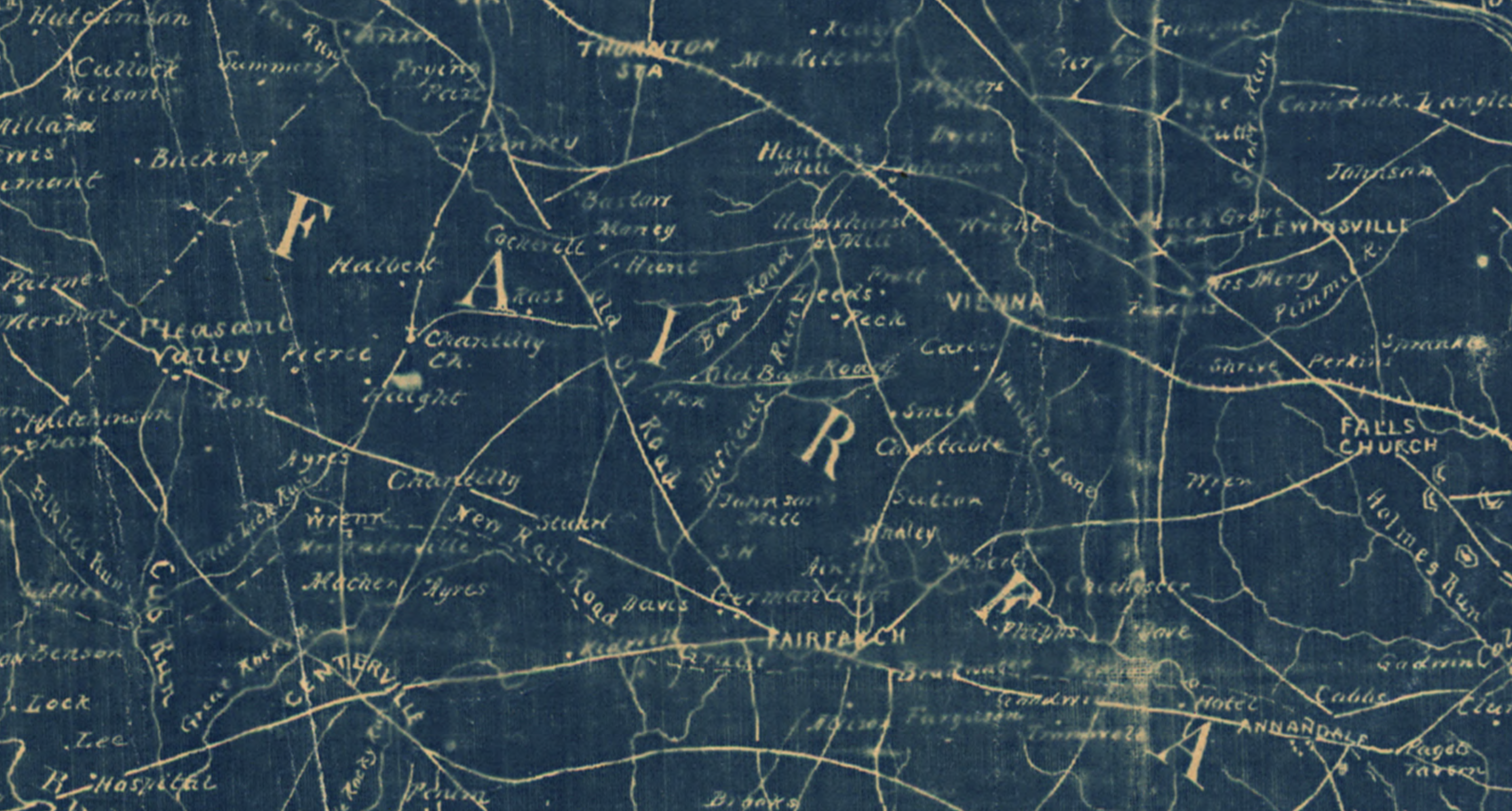
Years of research have produced an undeniable conclusion: Mosby and his men harnessed thickets, unlikely avenues, succession forests, friendly farms, and a collection of bridle paths into assets for a microwar that subsumed today’s Dulles Corridor. Slender trails that rarely appeared on maps and left the faintest traces on the muddy soil of Fairfax County became lethal highways.
By comparing and collaging advanced satellite imagery, extant maps, historic chancery records, tax rolls, censuses, first person narratives, genealogies, folklore, geology, geography, sociology, ethnography, and political history through a bifocal lens of spatial analysis and military studies, the shape and dimension of this lost war and the mysterious bridle paths on which it was fought appears from a murky past 160 years distant.
Start Here:
Deeper Reads:
-

Creek Hypothesis
TL;DR–By virtue of their loose formations and personal histories, Mosby’s Rangers potentially used creeks like roads.
4 min read
-

Klan Geographies
TL;DR–Overlapping geography and ideology (and potentially personnel) bridge the gap between John Mosby’s wartime operations and the post-war KKK in Fairfax County, Virginia
4 min read
-

Who Burned Fox’s Mill?
tl;dr–Fox’s Mill burned during the Civil War. The only people who know the exact details are long dead.
4 min read
-

Chantilly Approaches
tl;dr—To the south and west of the Difficult Run Basin, a belt of Mosby men and sympathizers owned large tracts of land with ideal terrain features for guerrilla…
4 min read
-

One or Many Ox Roads
TL;DR—At the time of the Civil War, the Ox Road west of Fairfax, Virginia, was actually two roads: “West” Ox Road and today’s Waples Mill Road.
4 min read
-

Tale of Two Maps
tl;dr — Considered at their smallest levels, rival Confederate and Federal maps of Difficult Run reveal superior Rebel place knowledge and multiple Yankee discrepancies
4 min read